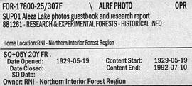
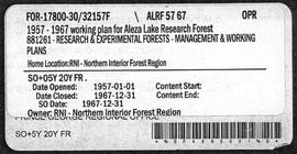
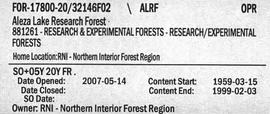
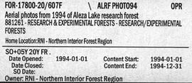
File contains colour aerial photography of the Aleza Lake Research Forest from 1994.
File contains slides and photos pertaining to the history of the Aleza Lake Experiment Station and the community.
File contains working plans from 1957, photographic records, and forecasted revenue records.
File contains various documents pertaining to the history of the Aleza Lake Experiment Station, correspondence regarding various administrative issues and research projects ranging from 1972 to 1996, field notes, 1996 meeting minutes, memoranda containing details on the management and preservation of the Aleza Lake Research Forest, various reports on research projects, 1987 permits, field notes, a 1970 working plan, and 6 colour photographs of the Aleza Lake Garbage Dump.
File consists of documents, radiograms, and correspondence regarding various administrative issues ranging from costs, living conditions, timber sales, research projects, and queries from the public. Much of this correspondence is between Tim Decie, Forester in Charge of Aleza Lake, and R.P Silsbury, Head of the Research Division between the years of 1953 and 1967. Also included are contracts and receipts from 1964, documents regarding the closure of the Aleza Lake Experiment Station, and meeting minutes.
Photographs are panoramas taken from the Churchill BC Forest Service Lookout, located at latitude 54°04' and longitude 122°16'. The photographs were bound together and include a transparent grid that was intended to be used for locating forest fires.
File consists of thin section micrograph images from the Boreal Cordilleran grassland soils study (2007 & 2008).
File contains handwritten notes, original diagrams, charts, studies, and black and white photos relating to Plot 108.
File contains handwritten cross section book, original studies with handwritten measurement charts and black and white photos, loose pages of original correspondence, handwritten diagrams and measurement charts, loose handwritten tally sheets, black and white photographs, hand coloured plot diagrams, photocopies of aerial photographs, and original correspondence for Plot 160.
File consists of a photograph commemorating the signing of the first Aleza Lake Research Forest Management Plan. Front row, left to right: Ken Pendergast, BC Forest Service Prince George District Manager; Harry Coates, BCFS Forest Research Technician (1957-1993); John Revel, BCFS Silviculture Forester (1960-1993). Back row, left to right: Mike [?], BCFS Prince George Silviculture Manager; Henry Benskin, BCFS Research Branch; Michael Jull, BCFS Research Silviculturist, Prince George Region; Dan Lousier, BCFS Prince George Region Research Section Head; Brian Harding, Northwood Pulp & Timber Ltd. Woodlands Manager.
File contains handwritten tables and graphs of measurements of plots, photocopied reports, 9 black and white photos, and handwritten notes.