Mostrar 109 resultados

Archival description
12 resultados com objetos digitais Mostrar resultados com objetos digitais
Russian Mine Tour
2000.1.1.1.13 · Dossiê/Processo · [between 1951 and 1992]
Parte de Cassiar Asbestos Corporation Ltd. fonds

Photographic negatives depict men on tour in unknown locations in Russia. Images depict urban areas, mining areas, construction of buildings, railway, mineral samples, and equipment including dump truck and electric shovel. Also includes images of area speculated to be a mine pit. Men on tour are dressed in formal attire.

Handwritten annotation in pencil on envelope containing negatives: "Russian 'Asbest' Mine Slides" "7 copies of each - 23 negatives - 161 prints".

Cassiar Aerial Photographs
2000.1.1.3.13 · Dossiê/Processo · 1950 - 1992
Parte de Cassiar Asbestos Corporation Ltd. fonds

Photographs depict aerial views of the Cassiar townsite, plantsite, tailings pile, mine road, bench and pit mine, mine buildings (tramline loading station, crusher, shop, and garage), and surrounding mountain range. Here "aerial" refers to photos depicting a large area and taken from the air or from a high point of elevation.

Tramline
2000.1.1.3.17 · Dossiê/Processo · [ca. 1955] - 1977
Parte de Cassiar Asbestos Corporation Ltd. fonds

File contains photographs featuring the tramline at Cassiar which ran from the crushing plant at the mountain mine to the plantsite in the valley (a drop of 427 meters). The first ore was originally transported by truck to the plant until the gravity chute was built in 1953. This chute was replaced with the first aerial tramline model in 1956, which was succeeded by the second model in 1975. This file also includes one photo of the original gravity chute, and one photo depicting a tramline worker.

Additionally there is a collection of eighteen photographs of tramline cars that were being surveyed for damage and condition, and another collection of six photographs of tramline study. The results of this study determined that there was variances in load sizes of the buckets caused by extra material falling off the panfeeder.

Official Tours
2000.1.1.4.1 · Dossiê/Processo · ca. 1968; 1978
Parte de Cassiar Asbestos Corporation Ltd. fonds

File contains photographs depicting four different tours that took place at the mine, plant, and towns owned by Cassiar Asbestos Corporation Ltd. Tours include Prime Minister Pierre Trudeau's visit to Clinton Creek in 1968 and Member of Parliament Iona Campagnolo's visit to Cassiar in 1978. Photographs also depict a party of ambassadors touring Cassiar in 1970, and the dedication of a building in the Cassiar plant in the late 1970s.

Board of Directors
2000.1.1.4.3 · Dossiê/Processo · ca. 1951 - ca. 1960
Parte de Cassiar Asbestos Corporation Ltd. fonds

File contains photographs featuring members of the Board of Directors of Cassiar Asbestos Corporation Ltd., which was formed on the 17th of May, 1951. Cassiar's forerunner was a company named Conwest, formed in 1534, a consolidation of two companies owned by Fred Martin Connell and his brother W. Harold Connell. The first board of directors included the Connell brothers, George Armstrong, John E. Kennedy, Charles & Arthur Mortimer, and Charles Rainforth Elliot (chartered accountant and secretary-treasurer of Conwest & Cassiar). Directors depicted in this file include F.M Connell, Harold Connell, Charles Elliot, John E. Kennedy, George Armstrong, Ken A. Creery, John Drybrough, Tam Zimmermann, George Washington Smith (president of Bell Asbestos Mines), Nick Gritzuk, Jack Christian (general manager, president, and CEO). Other individuals depicted include Fred Murry, Andre Beguin, Plato Malozemoff from Newmont Mining (co-founder of Cassiar with F.M. Connell), Alfred Lloyd Penhale (founder and CEO of Asbestos Corporation of Canada Ltd.), C.B. Brown, Pierre Marcotte, Francis Parker Smith (brother of George Smith), Bill Oughtred, Bill Johnson, and a Mr. Janitsch. File also includes a portrait of an unidentified director of Cassiar from Turner and Newall in England, taken at the corporate club in Toronto. Group portraits were taken at the Cassiar Valley, the office building, "House 130," fishing outings, and at formal events in unidentified locations.

Aleza Lake Various Historical Records
2007.1.25.2 · Dossiê/Processo · 1924-1968
Parte de Aleza Lake Research Forest fonds

File consists of documents, radiograms, and correspondence regarding various administrative issues ranging from costs, living conditions, timber sales, research projects, and queries from the public. Much of this correspondence is between Tim Decie, Forester in Charge of Aleza Lake, and R.P Silsbury, Head of the Research Division between the years of 1953 and 1967. Also included are contracts and receipts from 1964, documents regarding the closure of the Aleza Lake Experiment Station, and meeting minutes.

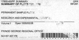
Summary of Plots 101-116
2007.1.45.27 · Dossiê/Processo · 1935
Parte de Aleza Lake Research Forest fonds

File contains handwritten tables and graphs of measurements of plots, photocopied reports, 9 black and white photos, and handwritten notes.

"A Summary: History and Progress"
2012.05.01.03 · Dossiê/Processo
Parte de Columbia Cellulose Company, Ltd. fonds

File consists of a document entitled "A Summary: History and Progress," which contains an overview of Columbia Cellulose Company's operations, ownership and financing, management staff, progress during 1968, three-year profit plan targets 1969-1971, and general information (magazine reprints, photographs, 1967 annual report, and 1968 interim reports).

1968 - Plantations 5003-5011 Prince George
2016.5.1.16 · Dossiê/Processo · 1968
Parte de Harry Coates fonds

File consists of Container Planting of Douglas-Fir, Lodgepole Pine and White Spruces in the Prince George Forest District in 1968: Working Plan. File includes data tables and photographs of seedlings and site.

Site and plot photos
2016.5.4.07 · Dossiê/Processo · [19-?]
Parte de Harry Coates fonds

File consists of 35 photographs of trees, cleared forest land, experimental plots sites, plantations, equipment, and one photograph of Harry Coates.

  • 8 photos in folder "FES [Forest Experiment Station] [Stem?] Mapping"; photos include pictures of the Aleza Lake Research Forest Sign, trees, 3 photos from CP 410 Oct. 1992, and photo of Aleza Lake E loop [trail?] 1992
  • Black and white photo of a young Harry Coates
  • 5 photos in folder "SHEEP July 1990" include 2 photos of cleared land (back of each photo reads "Sheep penny?") and 3 photos of a an unknown piece of forestry equipment
  • 8 photos in folder "Fire" of various locations of fire damaged forests in 1992
  • 13 photos in "More Planting" envelope; photos include 1 from Red Rock plantation in 1971; 2 from Cedar Plot in Valemont in Fall 1992; 2 from Cedar Goat R[oad] Fall 1992; 2 from [Compan Plantation?], Spittal Creek Fall 1992; Douglas Fir, Valemount - Cedar [Creal?]; Spaced Aspen Spittal Creek Fall 1992; 2 Cedar Plot, Spittal Creek, Fall 1992; Whit Pine Spittal Creek Fall 1992; Buckhorn B. Spruce 1978.
Northwood Spray
2016.5.4.13 · Dossiê/Processo · [1980-1999]
Parte de Harry Coates fonds

File consists of photographs of "partial willow kill - good Aspen + Fireweed control 147-009 85/87" largely depicting deforested land and young trees. Some photographs are aerial photographs.

EP 713 1972 Photos
2016.5.4.16 · Dossiê/Processo · 1972
Parte de Harry Coates fonds

File consists of photographs of sapling measurements for experiment 713.

Air Photos
2016.5.4.17 · Dossiê/Processo · [1967]
Parte de Harry Coates fonds

File consists of Air photos BC85019 no. 141-143, 197-198 and BC5249 no. 10, 12, and 29.

Air photographs of Fort Selkirk volcanic field, Yukon
2023.2.2.7.1 · Dossiê/Processo · 1960, 1971, 1989
Parte de Dr. Paul Sanborn fonds

In July 2009, Dr. Paul Sanborn undertook the first soils field research at the Fort Selkirk volcanic field in central Yukon, with helicopter support and funding from the Yukon Geological Survey. This file consists of prints of aerial photographs that depict the area accessed for the study, upstream from the confluence of the Yukon River and the Pelly River.

Air photographs include:
Flight line A17210, Photo Nos. 54-60 (taken 1960)
Flight line A22354, Photo Nos. 43-45, 47-48 (taken 1971)
Flight line A27516, Photo Nos. 48-52 (taken 1989)

Kluane Lake 2004 photographs - print roll 11
2023.2.2.8.17 · Dossiê/Processo · 2004
Parte de Dr. Paul Sanborn fonds

This file contains the following photographs in both print photograph and negative format:

Thorsen Bay
Print roll 11, #01-2A
Corresponding slides: slide roll 6, #12-10

Y04-19 (27.5 km on Cultus Bay Rd., near Thorsen Bay)
Date: July 22, 2004
Location Coordinates: 61º 12’ 3.0” N, 138º 28’ 58.3’ W, 819 m asl (± 18.9 m)
Site Description: Roadcut at base of 30º, E-facing slope. Colluviated loess overlies sandy glaciofluvial at 120 cm. Prominent paleosol with “cumulic” B horizon at 80-120 cm, with strong effervescence throughout exposure.
Print roll 11, #3A-5A (profile), #6A-10A (landscape)
Corresponding slides: slide roll 6, #9-7 (profile), #6-1 (landscape)

Sample Depths & Descriptions: Y04-19-01 – charcoal at 95 cm
Roadcut opposite ~ 30 m to NE on grassy S aspect (10° slope) with 15-20 cm of calcareous loess and sand over 2 cm White River ash; strongly effervescent throughout.
Print roll 11, #11A-12A (profile)
Corresponding slides: slide roll 7, #36-35 (profile)

Thorsen Bay landscape
Print roll 11, #13A-16A
Corresponding slides: Slide roll 7, #34-32

Y04-20B
Date: July 22, 2004
Location Coordinates: 61º 10’ 16.5” N, 138º 26’ 18.7’ W, 797.5 m asl (± 5.9 m)
Site Description: wind-eroded Slims soil on glaciolacustrine with contorted bedding (exposed on blown-out roadcut); calcareous to surface; White R ash pockets at 10-20 cm; S aspect, 5° slope.
Print roll 11, #17A-21A
Corresponding slides: Slide roll 7, #31-26

Y04-22
Date: July 22, 2004
Location Coordinates: 61º 9’ 39.24” N, 138º 25’ 7.8’ W, 790.6 m asl (± 6.4 m)
Site Description: toe of 30° slope, W aspect (grassy slope with poplar at toe); 1.0-1.2 of colluviated loess over gravelly glaciofluvial with buried soil at 70-80 cm
Print roll 11, #22A-24A
Corresponding slides: Slide roll 7, #25-24
Archie Creek slides
2023.2.2.10.2.8 · Dossiê/Processo · Sept. 1995
Parte de Dr. Paul Sanborn fonds

File contains 2 rolls (51 slides) taken September 25-26, 1995 that depict paired views of plot vegetation and forest floor surface. Handwritten number notations on slide frames indicate plot numbers from the original research installation.

Photographs
2022.03.01 · Dossiê/Processo · 1950-2005
Parte de Stowell Forestry Collection

File contains photographs of The Pas Lumber Company Ltd. Includes other northern BC forestry industry images, including Number 5 Timber Ltd. CP625 Block 101, bridge construction, and heavy machinery. Also includes a graphic postcard of Prince George circa 1970s.

Diamond core drilling
2000.1.1.1.11 · Dossiê/Processo · 1971- 1977
Parte de Cassiar Asbestos Corporation Ltd. fonds

Six metal storage cases containing primarily slides depicting drill core sections in wooden storage trays. Cases contain inventories of slide images as well as annotations which document the year, drill hole number, and the length along the drill hole from which core sections are taken. In addition to the documentation of drill core sections, the cases contain slides depicting the following subjects: “Representative samples” of drill core fragments, drill core fragments in perspective, “physical characteristics” of the drill cores and the storage trays, the pit mine, a worker in a plaid shirt, close up shots of the geology of the working face, and images annotated “SHOTS OF JADE BOULDER CORE J5-J1”. Five slides originally filed separately and stamp dated “Jul. ‘73” depict what is speculated to be employees working on the diamond drilling project include 2 images annotated ‘R. Dickin Aug ‘72’, ‘I. Oliver Aug ‘73’, ‘S. Zimmer Aug ‘73’, and ‘core shack ’73’. The cases contain 234 7x7cm slides and at least 8 5x5 cm slides which are duplicates of the remaining images. The file also contains a slide strip containing several 7x7 cm slide images.

Geology rock samples
2000.1.1.1.12 · Dossiê/Processo · 1977 - 1991
Parte de Cassiar Asbestos Corporation Ltd. fonds

The file contains eight photographs depicting close up images of three rock samples, some photographed with a ruler for scale. One of the rock samples is speculated to be obsidian and the other two are likely serpentine. The images where originally found in an envelope titled "ROCKS" and are likely dated around 1991.

Included in this file are an five photographs of rocks on a shelf, which may be asbestos sample rocks. There are five accompanying negatives to these photographs and are likely dated around 1977. The photographs and negatives were found in an envelope labelled "Negatives - CIMM Photos."

Additionally two negative strips of geology maps of Canada. These negatives were found in an envelope labelled "Negatives - CIMM Papers, Mining, Planning, Geology."

Landslides
2000.1.1.3.06 · Dossiê/Processo · 1979 - 1989
Parte de Cassiar Asbestos Corporation Ltd. fonds

File contains images depicting various landslides near Cassiar BC. Set of 20 photographs (with 9 corresponding negative strips) date stamped June 1987 depict landslide near creek and dirt road with a Cassiar company truck. Set of 5 black and white photographs found in envelope marked "D. Stewart" are likely from 1988-1989 and depict a rockslide on the south western side of the pit mine, near the tramline. Album entitled “6200 DUMP SLIDE / SPRING, 1979” contains 34 photographs depicting aerial shots of a massive rockslide on the eastern slope of McDame Mountain, originating from the mine waste dump. Several images from album show greenish water pooling in the toe of the slide.

Superintendent’s Office 1988
2000.1.1.3.08 · Dossiê/Processo · July 1987 - Apr.1989
Parte de Cassiar Asbestos Corporation Ltd. fonds

File contains images of mine operations and construction, as well as a variety of other subjects.

  • Elements of the underground mine are depicted, including miners working, the marked rock face, yellow ducting and ventilation fan, the portal, mesh rockbolted onto adit walls, shotcrete being applied, and stacked mining construction materials.
  • Mining equipment depicted in this file includes underground ore haulage truck, Wabco ore haulage truck, jackleg drill, stoper drill, scoop tram, jumbo drill, conveyor, pickup trucks, unidentified mixing or grinding machine, a cable wagon and half constructed ore haulage truck in the shop, and a continuous miner (also known as alpine miner or roadheader).
  • A set of images show a dozer and a lowbed truck transporting a temporary building down the pit mine access road.
  • Several images depict drill core fragments, asbestos ore, and geological features of the mine.
  • Mining related process are depicted, including a young man sluicing and panning, a mine building under construction, and an unidentified steel frame structure with a hydraulic device suspended on a rail.
  • A set of images shows a railway or highway construction project, including stockpile of construction materials, rail cars, caboose, locomotive, front end loader, dump truck, concrete mixing trucks, semi-trucks, and a rail car with large steel drums which are speculated to be specialized for tunnel construction.
  • Further images show what is speculated to be tunnel construction.
  • A set of images at a high ceiling underground mine which is not Cassiar depicts a man in a suite by a underground ore haulage truck, and other mining vehicles including a crane.
  • A set of images depict an ungulate herd, possibly bighorn sheep, on a mountain side.
  • The file includes several images which depict personal life, presumably from a family vacation, and access to these images may be restricted. These images depict man with children on a fishing trip, adults and children around a pool, a woman on a motorcycle, and a house and kitchen. Several groups of images are contained in envelopes annotated with dates and “K. Minty”.
Mine (1952 to 1972)
2000.1.1.3.15 · Dossiê/Processo · 1953 - 1970
Parte de Cassiar Asbestos Corporation Ltd. fonds

File contains photographs depicting machinery, individuals, buildings, and mining processes at the open mine on McDame Mountain, Cassiar, B.C. Some photos depict benches from open strip mining, and two images feature models of the mine (1955 and 1970). Machinery depicted includes shovels, bulldozers, tractors, ore haul trucks (Kenworth, International Harvester, and Wabco), air track drills, blasthole drills, and Ingersoll-Rand Drill. Identified individuals include Fred Murray, R.R. [Kiresan?], C.E. Bronson, Bill Giachino, and "Sam".

Mine (1973 to 1991)
2000.1.1.3.16 · Dossiê/Processo · 1973-1991
Parte de Cassiar Asbestos Corporation Ltd. fonds

File contains photographs featuring:

  • the pit mine: fault line, geology, snowdrifts, plowed snow, blast patterns marked by orange cones, mist, and surrounding mountains.
  • Pit mine is depicted by aerial photographs and a profile diagram.
  • Several photographs also depict what is speculated to be the portal to the underground mine adit in the early phases of development.
  • One photograph depicts the shop building in the pit mine, used for maintenance of mining equipment and to house the primary crusher.
  • Several photographs show office interiors and personnel and it is speculated that these photographs were taken in the upper floor of the shop building.
  • Several photographs depict small sinkholes in the pit mine.
  • Mining equipment depicted includes pickup trucks, front end loaders (including a Cat 988), ore haulage trucks, scoop trams, D8 Caterpillar dozer, grader, mining drill rig, jumbo drill, rock hammer, P&H excavator, and wireline extensometer. Photolab envelopes accompanying these materials were annotated “R. Tyne” and “falling ground”. Slide sleeves were annotated “Mine Nov-Dec 1975”, “AERIAL SHOTS OF MINE 1976” and “Phase 8 Dec 1975”.
  • Photographs of a Gardner Denver blasting drill at the mine and other ground drills working
  • Photograph of proposed power line to #1 switchback in 1975,
  • Collection of photographs of a Wsbco truck with corresponding mechanical transfers of those photographs.
  • Also photographs a Gardner Denver drill and a Bucyrus Erie drill that was rented to Cassiar Mine in 1974. This collection includes a depiction of an accident with these drills.
  • An additional collection of photographs of #709 Drill that was involved in minor accident. A pipe was either damaged or was the cause of the accident.
  • Negative collection of photographs with corresponding notes of descriptions.
  • Photographs of G.D. 80 Drill - Blasthole drill at work in the open pit.
  • Photographs part of Month End Reports from January - June 1980
  • Photographs of portable toilets used on Mine site.
  • Photograph collection of mine garage January 21, 1988
  • Photograph collection of what is believed to be the inside of the mine garage and various storage units and equipment. Marked "Receiver File" in original enclosure.
  • Photos of Crane in 1984.
  • An Album of 192 photographs of machinery in March of 1976 working at the mine site. Some of the equipment from either the plantsite or the mill is also depicted.
Awards
2000.1.1.4.2 · Dossiê/Processo · 1962 - 1978
Parte de Cassiar Asbestos Corporation Ltd. fonds

File contains photographs depicting superintendents accepting safety awards on behalf of Cassiar Asbestos Corporation ltd, and BCIT Scholarship Winners.

Promotion & Outreach
2000.1.1.4.4 · Dossiê/Processo · 1963 - 1978
Parte de Cassiar Asbestos Corporation Ltd. fonds

File contains photographs taken for promotional purposes.

  • Two photos depict a Cassiar display at an unknown event in 1963.
  • Eight photos were professionally taken for use in the 1978 Cassiar Asbestos Corportaion Ltd. Annual Report, and possibly other publications. These photos depict a skyscraper and products made with asbestos.
  • Additionally, two hand painted postcards of McDame Mountain and Christmas Tree House are included that may have been used for promotional reasons. Also, four slides of a display, "Story of Asbestos."
  • five photographs of unofficial tour of Cassiar via airplane in the 1970s.
The Bourchier Album
2009.5.3 · Dossiê/Processo · [ca. 1895 - 1950]
Parte de Taylor-Baxter Family Photograph Collection

This photograph album consists of photographs of remote police barracks at Mile 47 and Mile 29; early settlements and/or mercantile stores at Tete Jaune Cache, McBride, Sand Creek, Fort George and South Fort George; Grand Trunk Pacific Railway forestry and railway camps; scows and paddlewheel conveyors on the Fraser River; automobiles; community leisure activities; as well as, images of the Bourchier family. The following South Fort George establishments are identifiable within these photographs: Empress Hotel, Ah Yee General Merchant, German Bakery, Northern Hotel, South Fort George Drug Store & Post Office, St. Michael’s Church, Prince George Hotel, Ford Monarch dealership, Astoria Hotel, and King George V Elementary School. Identified geographic locations featured in these photographs include: Tete Jaune, Upper Fraser, Mile 47, Mile 29, Fraser River, Mt. Robson, McBride, Sand Creek, Glacier Mountain, Moose River, Giscome Portage, Pott Falls, Red Deer River, Grand Canyon, Summit Lake, Canoe Pass, Connaught Hill, Nechako Bridge, and Island Cache.

Sem título
2007.11.4.12 · Dossiê/Processo · [between 1998 and 2007]
Parte de McGregor Model Forest Association fonds

File consists of 23 posters of two sizes about the McGregor Model Forest Association and the Model Forest Network. Many of the posters are laminated and have Velcro attachments on the back for use during presentations or conferences. The information presented is varied, but includes vision statements, maps, Phase III themes and activities, recent successes, programs, information about various projects, maps illustrating model forests across Canada, phase and project objectives, information on the TFL-30 project, and information about the computer program developed by the McGregor Model Forest Association. Some simple posters advertising both the MMFA and the Canadian Model Forest Network are featured.

Skeena Kraft Limited Press kit
2012.05.01.01 · Dossiê/Processo · Jun. 1967
Parte de Columbia Cellulose Company, Ltd. fonds

File consists of a folder containing documents describing Skeena Kraft Limited. Folder consists of:

  • Svenska Cellulosa Aktiebolaget--A Forest Products Giant
  • Columbia Cellulose Company, Limited--A Corporate History
  • Two World-Wide Sales Organizations to Market Skeena Kraft Pulp
  • Skeena Kraft Limited Adopts Distinctive Housemark Symbol Adapted from Sun Totem, Kee-War-Kow, Family Crest of Sky People
  • The Nass and Skeena Valleys--A New Economic Region Terrace and Prince Rupert are Hubs in Finance and Services
  • MISSING: Twinriver Timber Limited: New Company Created to Administer Two Tree Farm Licence Areas
  • The Forests Behind the Coast Range Produce Superior Pulp
  • Efficient New Woodroom Highlights Skeena Mill
  • Integrating Two Power Systems--A Marriage with Convenience One Power Group Serves Two Mills
  • Pulping Group Features Flexible Bleaching Sequence and World's Largest Flakt Drier
  • New Dams Create Huge Storage Area for Skeena Water Supply
  • Advanced Process Control Techniques Employ Computers Extensively
  • Skeena Kraft Mill Quality Control and Process Control Tune Mill to Produce Prime Quality Pulps
  • Co-ordination and Administration of Construction and Design of Skeena Kraft Shared by H.A. Simons and Central Engineering of Columbia Cellulose
  • Purchasing and Traffic Departments Buy and Move More than 25,000 Tons of Materials During Skeena Kraft Construction Co-ordinated Sea and Land Transport System Introduced
  • Skeena Kraft--Hundreds of New Jobs Canada-Wide Recruiting Programme Attracts New Workers to Growing Nass-Skeena Region;
  • Also includes 19 photographs; 12 technical drawings and diagrams; 2 maps;
  • Promotional pamphlet "The Skeena Kraft Story."
Giscome Farm Ltd.
2012.13.4.27 · Dossiê/Processo · 2002-2004
Parte de J. Kent Sedgwick fonds

File consists of notes, clippings, and reproductions relating to the Giscome Farm Ltd. File also includes photographs depicting the Giscome Farm.

Plot maps, photos, and reports
2016.5.1.45 · Dossiê/Processo · 1992-1994
Parte de Harry Coates fonds

File consists of several maps indicating the locations of plots and 3 detailed maps of specific plots. File also includes photographs of cleared forests and a "P.G. District Demonstration Plots: Establishment Report".

Certificates and Photographs
2016.5.1.98 · Dossiê/Processo · [1962-1992]
Parte de Harry Coates fonds

File consists of a licence and framed certificates and photographs for Harry Coates. File includes:

  • Scaling Licence (1962)
  • two certificates celebrating Harry Coates' 25 years of service with the Forest Service (1982)
  • photograph of Harry Coates, [Ted or Jed?] Baker, and John Revel at Aleza Lake Research Forest Re-opening July 9, 1992.
  • Photograph of Harry Coates and John Revel, identifying plaque reads "Buckhorn Lake E.P. 660".
Air Photos
2016.5.4.06 · Dossiê/Processo · 1973 & 1985
Parte de Harry Coates fonds

File consists of 10 air photos: BC85019 No. 111, 112, 140, 199 (CFS McGregor written on reverse), 200; BC77004 No. 199 (comment on reverse re location of tie point, 200; and 3 higher altitude air photos with no obvious label. Note that BC77004 No. 199 and 200 have MOF stamps on the reverse.

EP 668 photographs and notes
2016.5.4.09 · Dossiê/Processo · 1972-[199-?]
Parte de Harry Coates fonds

File consists of two sets of photographs. The first set consists of 19 photographs of a cleared site with evidence of former fire damage and new growth. The second set consists of 40 photographs from EP 668 from 1972 of seedling or [wildling] heights, this set of photographs are documented with notes.

Photographs 1985-87
2016.5.4.10 · Dossiê/Processo · 1984-1987
Parte de Harry Coates fonds

File consists of 47 photographs of cleared forest with some regrowth. File includes images from Prince George West - Bill's Creek 104:814: 85/87 Unit 'A'; Red Rock seed orchard July 22, 1986 Permit no. 400-360: 86/87; Mackenzie Forsar Project 86-9-9 adjacent to velpar treatment; 147-005 84/86 TFL 30 CP 5 #26; 147-008 85/87 TFL 30 CP.5 Unit 1; Northwood TFL 30 CP 12E Unit 15, Pesticide use permit #147-012:85/87.

Aleza Lake Photographs
2016.5.4.20 · Dossiê/Processo · [19-?]
Parte de Harry Coates fonds

File consists of 26 photographs including: 10 images of Aleza Lake Research Forest aerial photos; 4 images of packed cones from Red Rock to Duncan 1970; 11 black and white forestry photographs; photo of J. Revel.

Kluane Lake 2003 photographs - print roll 5
2023.2.2.8.12 · Dossiê/Processo · 2003
Parte de Dr. Paul Sanborn fonds

This file contains the following photographs in both print photograph and negative format:

Slims River delta
Date: August 11, 2003
(location not recorded)
Print roll 5, #1-3 (Corresponding slides: Slides roll 3, #15-14)

Grizzly bear
Date: August 12, 2003
(beside Cultus Bay Rd.; location not recorded)
Print roll 5, #6-7

Y03-08 (Cultus Bay Rd. – at top of switchbacks)
Date: August 12, 2003
Location Coordinates: 61° 3’ 43.1” N, 138° 21’ 4.0” W, 833.8 m asl (± 5.1 m)
Site Description: good exposure of loess (35 cm) with Slims Soil over glaciofluvial terrace – pinches out downslope [note: this site was sampled because of development of buried paleosol, and was not part of biological crust study by Marsh et al. (2006)]
Sample Depths & Descriptions:

  • Y03-08-01 - 45-48 cm - Ahkb (7.5YR 3/3 d; strongly effervescent)
  • Y03-08-02 - 48-56 cm - Bmkb (7.5YR 4/3 d; strongly effervescent)
  • Y03-08-03 - 56-70 cm - Ccab (2.5Y 5/2 d; strongly effervescent)
  • (not sampled) - 70 cm+ - IICca (glaciofluvial; strongly effervescent)
  • Intact sample: 56-36 cm - depth (including Slims Soil)
    Print roll 5, #8-10, 17-18 (Corresponding slides: Slides roll 3, #13-11, 5-4)

Y03-09 (cliff top on E. shore of Kluane L. at Christmas Bay)
Date: August 12, 2003
Location Coordinates: 61° 4’ 0.0” N, 138° 22’ 35.3” W, 828.3 m asl (± 7.3 m)
Site Description: ~ 60 cm loess over glaciofluvial gravels
Sample Depths & Descriptions:

  • Y03-09-01 - Nostoc crust
  • Y03-09-02 - Tortula ruralis – Cetraria crust
  • Y03-09-03 - 0-14 cm - ACk (10YR 3\2 d)
  • Y03-09-04 - 14-16 cm - Ahkb1 (10YR 2/2 d)
  • Y03-09-05 - 16-18 cm - Ck1 (10YR 4/3 d)
  • Y03-09-06 - 18-20 cm - Ahkb2 (10YR 3/2 d; discontinuous)
  • Y03-09-07 - 20-27 cm - Bmkb1 (10YR 4/3 d)
  • Y03-09-08 - 27-33 cm - Bmkb2 (7.5YR 4/3 d)
  • Y03-09-09 - 33-46 cm - Bmkb3 (10YR 4/3 d)
  • Y03-09-10 - 46-55 cm - Ck2 (2.5Y 5/3 d)
  • (not sampled) - 55-60 cm+ - IICk (glaciofluvial gravels)
    Print roll 5, #11-15 (Corresponding slides: Slide roll 3, #10-6)

Y03-10 (shore bluff N. of Silver City)
Date: August 12, 2003
Location Coordinates: 61° 2’ 55.0” N, 138° 23’ 17.2” W, 806.7 m asl (± 7.3 m)
Site Description: 70% slope, SW aspect; vegetation: Elymus, Carex, Artemisia, Erigeron
Sample Depths & Descriptions:

  • Y03-10-01 - Crust
  • Y03-10-02 - 0-18 cm - ACk (10YR 4/2 m; strongly effervescent)
  • Y03-10-03 - 18-25 cm - Ahkb(?) (10YR 4/2 m; strongly effervescent)
  • Y03-10-04 - 25-40 cm - Ck (2.5Y 5/2.5 m; strongly effervescent)
  • (not sampled) - 40 cm+ - IICk (glaciofluvial gravels; strongly effervescent)
    Print roll 5, #19-22 (Corresponding slides: Slide roll 3, #3-1)

Silver City ghost town (location not recorded)
Date: August 12, 2003
Print roll 5, #23-24

Y03-11 (Silver City road section)
Date: August 12, 2003
Location Coordinates: 61° 2’ 3.6” N, 138° 22’ 48.8” W, 806.7 m asl (± 8.7 m)
Site Description: roadcut through SW-facing hill exposes loess over glaciofluvial gravel, with 4 paleosols in colluviated loess
Sample Depths & Descriptions:

  • Y03-11-01 - 0-18 cm - ACk (fresh loess)
  • Y03-11-02 - 18-47 cm - Soil 1 – Bmk
  • Y03-11-03 - 47-100 cm - Loess
  • Y03-11-04 - 100-110 cm - Soil 2 – includes charcoal
  • Y03-11-05 - 110-160 cm - Loess with secondary carbonate in root channel
  • Y03-11-06 - 160-170 cm - Soil 3 – Ahk with charcoal
  • Y03-11-07 - 160-170 cm - Soil 3 – Bmk
  • Y03-11-08 - 170-198 cm - Loess with secondary carbonate in root channel
  • Y03-11-09 - 198-202 cm - Soil 4 – Ahk – laterally continuous for ~ 1.5 m
  • Y03-11-10 - 202-230 cm - Loess with secondary carbonates in roots
  • Y03-11-11 - 230-255 cm - Soil 5 – Ahk – includes abundant charcoal bands
  • Y03-11-12 - 230-255 cm - Soil 5 – Bmk – infilled squirrel burrows immediately below
  • Y03-11-13 - 255-300 cm+ - Loess
    Additional notes on modern soil & paleosols:
    Soil 1
  • consists of Bmk horizon material with 2 distinct colours: 7.5YR 4/3 d & 10YR 4/3 d
  • loess between Soils 1 & 3 is sandier
    Soil 2
  • 90% Ahk material, 2-10 cm thick
  • Ahk – 10YR 3/2 d
  • Bmk – 7.5YR 4/2 d
  • less abundant carbonate than in paleosols & loess below
    Soil 3 - most of exposure has Ahk (2-5 cm thick) over Bmk (4-10 cm thick), with carbonates as for Soil 5
    Soil 4 - mostly Ahk (10YR 3/2 d) material 2-8 cm thick, some Bmk (10YR 4/2 d) < 2 cm thick, with carbonates as for Soil 5
    Soil 5
  • complex intermixing of Ahk & Bmk material, charcoal most abundant in Ahk
  • individual colour bands 2-10 cm thick
  • overall dip of horizons (10° to W) is parallel to surface
  • similar size & density of secondary carbonates as in loess above & below; associated with root channels, < 5 mm diameter, covering ~ 5% of surface
    Print roll 5, #26-30 (Corresponding slides: Slide roll 4, #36-32)
Experimental Project (EP) 660 slides
2023.2.2.10.1.6 · Dossiê/Processo · Aug. 1997
Parte de Dr. Paul Sanborn fonds

File contains 8 slides from 2 rolls, taken August 1997:
Roll 1 - Buckhorn Ridge:

  • Slide 31 – Fd (2 x 2 m) – stand view
  • Slide 32 – Fd (2 x 2 m) – forest floor view
  • Slide 33 – Pl (2x 2 m) – stand view
  • Slide 34 – Pl (2 x 2 m) – forest floor view
    Roll 2 – Bobtail Road:
  • Slide 20 – Pl (2 x 2 m) – east plot, stand view
  • Slide 21 – Pl (2 x 2 m) – east plot, stand view
  • Slide 22 – Fd (2 x 2 m) – east plot, stand view
  • Slide 23 – Sw (2 x 2 m) – stand view
Thetford Mines, Quebec
2000.1.1.1.15 · Dossiê/Processo · [ca. 1975]
Parte de Cassiar Asbestos Corporation Ltd. fonds

The file contains photographs originally found in an unmarked and undated black binder depicting colour-coded mill equipment and machinery. Several of these images are annotated “Bell”, “Bell Asbestos”, and “National”. It is speculated that these images originate from the underground asbestos mine in Thetford Mines, Quebec operated by Bell Asbestos Mines Ltd. and the National Mine in Quebec. One image appears to be, or looks similar to the new mill at Cassiar, built in 1971.

Bagging Machinery at Nordenham, Germany
2000.1.1.1.16 · Dossiê/Processo · 1978
Parte de Cassiar Asbestos Corporation Ltd. fonds

File contains photographs annotated Nordenham, presumably indicating that these images were taken in the Asbestos Corporation's plant in Nordenham Germany. The images depict bagging machinery in the mill, including a palletizer, automatic sewing machine, packer, shrinkwrap machine, glue applicator and cement bags. Some of the images include detailed annotations.