Print preview Close

Showing 109 results

Archival description
12 results with digital objects Show results with digital objects
2000.1.1.3.10 · File · November 1990 - June 1991
Part of Cassiar Asbestos Corporation Ltd. fonds

File contains images depicting the underground mine at Cassiar, showing structural damages, repaired damage ground support, and mining and repair processes.

The file contains a photo inventory entitled “Underground Mine Structural Inspection, Rock Mechanics Dept. Foto Documentation” with a complete file inventory linking the picture number to a location, title, and dated film. This photographic documentation was assembled for the purposes of liaising with a underground mining consultant located in South Africa.

  • Images document structural ground support including steel cables, support arches, metal mesh, shotcrete, rockbolts, wooden beams.
  • Images show ground support damaged through ground movement, but some depict newly installed or repaired support.
  • Images depict ventilation ducting that was crushed or torn.
  • Mining processes depicted include miners installing a rock breaker, miners paving the adit floor with concrete, miners inspecting a damaged section of mine, miner loading drill or blastholes with ANFO (ammonium nitrate / fuel oil mixture) explosives, and long hole drilling.
  • Technical elements of the underground mine depicted include a mining device and ore in a chute (annotated ‘1290 crusher’), the conveyor, ‘LH drill’, ore processing machine annotated ‘1350 breaker’, and an electrical box titled ‘Weighometer’.
  • Specific locations shown include ore draw points, ore passes, access drifts, a hatch and door titled “Fuel station 1415”, and a dead end drift with a stack of equipment and an orange cable annotated “1335 access electrical stations”.
Underground mine
2000.1.1.3.09 · File · 1988-1992
Part of Cassiar Asbestos Corporation Ltd. fonds

This file contains various aspects of the underground mine.

  • Photos depicting damage to the underground mine such as fallen rocks, cracked shotcrete, twisted rock bolts and metal mesh, exposed and damaged steel structural frames, and repairs underway.
  • Steel cables, chains, support arches, and custom welded rebar frames used in the structural reinforcement of the underground mine.
  • Several engineering tests related to the structural damages are depicted.
  • Two sets of images show a Porta Power hydraulic tool with a ready rod attached, a hand pump, as well as images of a technician testing the holding power of a rock bolt.
  • Set of images documents a technician drilling cores and installing extensometer anchors, as well as grouting the anchors and connecting an extensometer. Technicians are shown inspecting damages with a ruler and rockhammer for scale.
  • A set of images showcase the threaded rebar, nuts, and face plates used for rockbolts.
  • Utility vehicles, yellow vent ducting, and utility pipes are visible in several images.
  • Also include is an image of a man in office space, foggy night scene with a telephone pole, office desk, stack of supplies including concrete, steel cable, and spray paint, and several images of a broken piece of ore and concrete outside the mine portal.
  • Several images depict miners working in the bucket of a scoop tram.
  • Photos of the stramler feeder breakers, which was used in the underground mine.
  • Images of ground support verifications where the deficiency of the exhaust ramp was investigated. This collection has various annotations explaining the broken shotcrete and the wire mesh installed.
  • A collection of photographs depicting tunnel shotcrete failures. Each photograph has an accompanied textual annotation.
  • Photos of MMD #750 Sizer equipment - assumed used in Underground Mine.
  • Photos of pump used in 1335 level, wheel fan for ventilation removed from 1350 level,
  • A collection of ground fall event 29 March 1989 - with annotations depicting damage
Tramline
2000.1.1.3.17 · File · [ca. 1955] - 1977
Part of Cassiar Asbestos Corporation Ltd. fonds

File contains photographs featuring the tramline at Cassiar which ran from the crushing plant at the mountain mine to the plantsite in the valley (a drop of 427 meters). The first ore was originally transported by truck to the plant until the gravity chute was built in 1953. This chute was replaced with the first aerial tramline model in 1956, which was succeeded by the second model in 1975. This file also includes one photo of the original gravity chute, and one photo depicting a tramline worker.

Additionally there is a collection of eighteen photographs of tramline cars that were being surveyed for damage and condition, and another collection of six photographs of tramline study. The results of this study determined that there was variances in load sizes of the buckets caused by extra material falling off the panfeeder.

Trails and equipment
2016.5.4.02 · File · [after 1959]
Part of Harry Coates fonds

File consists of 29 photographs of silviculture activities and equipment. Photographs include:

  • 4 photos from Buckhorn EP [549.3] * 2 photos of a "bracke mounder" attachment
  • 21 photos of mounding and herbicide trial(s)
  • a large photo of a seedling
  • a large photo of Harry Coates measuring a small tree.
Thetford Mines, Quebec
2000.1.1.1.15 · File · [ca. 1975]
Part of Cassiar Asbestos Corporation Ltd. fonds

The file contains photographs originally found in an unmarked and undated black binder depicting colour-coded mill equipment and machinery. Several of these images are annotated “Bell”, “Bell Asbestos”, and “National”. It is speculated that these images originate from the underground asbestos mine in Thetford Mines, Quebec operated by Bell Asbestos Mines Ltd. and the National Mine in Quebec. One image appears to be, or looks similar to the new mill at Cassiar, built in 1971.

The Bourchier Album
2009.5.3 · File · [ca. 1895 - 1950]
Part of Taylor-Baxter Family Photograph Collection

This photograph album consists of photographs of remote police barracks at Mile 47 and Mile 29; early settlements and/or mercantile stores at Tete Jaune Cache, McBride, Sand Creek, Fort George and South Fort George; Grand Trunk Pacific Railway forestry and railway camps; scows and paddlewheel conveyors on the Fraser River; automobiles; community leisure activities; as well as, images of the Bourchier family. The following South Fort George establishments are identifiable within these photographs: Empress Hotel, Ah Yee General Merchant, German Bakery, Northern Hotel, South Fort George Drug Store & Post Office, St. Michael’s Church, Prince George Hotel, Ford Monarch dealership, Astoria Hotel, and King George V Elementary School. Identified geographic locations featured in these photographs include: Tete Jaune, Upper Fraser, Mile 47, Mile 29, Fraser River, Mt. Robson, McBride, Sand Creek, Glacier Mountain, Moose River, Giscome Portage, Pott Falls, Red Deer River, Grand Canyon, Summit Lake, Canoe Pass, Connaught Hill, Nechako Bridge, and Island Cache.

Bourchier, Alan K.
Tab 657
2016.5.4.04 · File · [after 1958]
Part of Harry Coates fonds

File consists of 19 photographs depicting Harry Coates, experiments, landscapes, and air photos, including:

  • Photo pf Harry Coates ca. 1958 at Aleza lake Experiment Station
  • Photo of Lloyd Brothers at Cluculz Lake, Gordon Talbot
  • 3 photos: including a photo of pine trees, a photo of Harry Coates with a damaged tree, and a photo of a damaged pine
  • 1 photo of a young man in safety gear sitting in the back of a parked pickup struck, holding circular saw and smiling at the camera
  • 3 photos of cleared forest in the winter
  • 2 photos from EP 442 Wansa Lake, P. 60, 61 and 70
  • 3 photos of Fire Study June 1984
  • 1 photo of EP 657.03 Squirral Damage, June 1984
  • 1 photo EP 868.07 McBride May 1984
  • 3 photos of Bobtail Demo 660 in 1992, EP 657.03.
2000.1.1.3.08 · File · July 1987 - Apr.1989
Part of Cassiar Asbestos Corporation Ltd. fonds

File contains images of mine operations and construction, as well as a variety of other subjects.

  • Elements of the underground mine are depicted, including miners working, the marked rock face, yellow ducting and ventilation fan, the portal, mesh rockbolted onto adit walls, shotcrete being applied, and stacked mining construction materials.
  • Mining equipment depicted in this file includes underground ore haulage truck, Wabco ore haulage truck, jackleg drill, stoper drill, scoop tram, jumbo drill, conveyor, pickup trucks, unidentified mixing or grinding machine, a cable wagon and half constructed ore haulage truck in the shop, and a continuous miner (also known as alpine miner or roadheader).
  • A set of images show a dozer and a lowbed truck transporting a temporary building down the pit mine access road.
  • Several images depict drill core fragments, asbestos ore, and geological features of the mine.
  • Mining related process are depicted, including a young man sluicing and panning, a mine building under construction, and an unidentified steel frame structure with a hydraulic device suspended on a rail.
  • A set of images shows a railway or highway construction project, including stockpile of construction materials, rail cars, caboose, locomotive, front end loader, dump truck, concrete mixing trucks, semi-trucks, and a rail car with large steel drums which are speculated to be specialized for tunnel construction.
  • Further images show what is speculated to be tunnel construction.
  • A set of images at a high ceiling underground mine which is not Cassiar depicts a man in a suite by a underground ore haulage truck, and other mining vehicles including a crane.
  • A set of images depict an ungulate herd, possibly bighorn sheep, on a mountain side.
  • The file includes several images which depict personal life, presumably from a family vacation, and access to these images may be restricted. These images depict man with children on a fishing trip, adults and children around a pool, a woman on a motorcycle, and a house and kitchen. Several groups of images are contained in envelopes annotated with dates and “K. Minty”.
2012.05.01.01 · File · Jun. 1967
Part of Columbia Cellulose Company, Ltd. fonds

File consists of a folder containing documents describing Skeena Kraft Limited. Folder consists of:

  • Svenska Cellulosa Aktiebolaget--A Forest Products Giant
  • Columbia Cellulose Company, Limited--A Corporate History
  • Two World-Wide Sales Organizations to Market Skeena Kraft Pulp
  • Skeena Kraft Limited Adopts Distinctive Housemark Symbol Adapted from Sun Totem, Kee-War-Kow, Family Crest of Sky People
  • The Nass and Skeena Valleys--A New Economic Region Terrace and Prince Rupert are Hubs in Finance and Services
  • MISSING: Twinriver Timber Limited: New Company Created to Administer Two Tree Farm Licence Areas
  • The Forests Behind the Coast Range Produce Superior Pulp
  • Efficient New Woodroom Highlights Skeena Mill
  • Integrating Two Power Systems--A Marriage with Convenience One Power Group Serves Two Mills
  • Pulping Group Features Flexible Bleaching Sequence and World's Largest Flakt Drier
  • New Dams Create Huge Storage Area for Skeena Water Supply
  • Advanced Process Control Techniques Employ Computers Extensively
  • Skeena Kraft Mill Quality Control and Process Control Tune Mill to Produce Prime Quality Pulps
  • Co-ordination and Administration of Construction and Design of Skeena Kraft Shared by H.A. Simons and Central Engineering of Columbia Cellulose
  • Purchasing and Traffic Departments Buy and Move More than 25,000 Tons of Materials During Skeena Kraft Construction Co-ordinated Sea and Land Transport System Introduced
  • Skeena Kraft--Hundreds of New Jobs Canada-Wide Recruiting Programme Attracts New Workers to Growing Nass-Skeena Region;
  • Also includes 19 photographs; 12 technical drawings and diagrams; 2 maps;
  • Promotional pamphlet "The Skeena Kraft Story."
Site and plot photos
2016.5.4.07 · File · [19-?]
Part of Harry Coates fonds

File consists of 35 photographs of trees, cleared forest land, experimental plots sites, plantations, equipment, and one photograph of Harry Coates.

  • 8 photos in folder "FES [Forest Experiment Station] [Stem?] Mapping"; photos include pictures of the Aleza Lake Research Forest Sign, trees, 3 photos from CP 410 Oct. 1992, and photo of Aleza Lake E loop [trail?] 1992
  • Black and white photo of a young Harry Coates
  • 5 photos in folder "SHEEP July 1990" include 2 photos of cleared land (back of each photo reads "Sheep penny?") and 3 photos of a an unknown piece of forestry equipment
  • 8 photos in folder "Fire" of various locations of fire damaged forests in 1992
  • 13 photos in "More Planting" envelope; photos include 1 from Red Rock plantation in 1971; 2 from Cedar Plot in Valemont in Fall 1992; 2 from Cedar Goat R[oad] Fall 1992; 2 from [Compan Plantation?], Spittal Creek Fall 1992; Douglas Fir, Valemount - Cedar [Creal?]; Spaced Aspen Spittal Creek Fall 1992; 2 Cedar Plot, Spittal Creek, Fall 1992; Whit Pine Spittal Creek Fall 1992; Buckhorn B. Spruce 1978.
Sinclair Mills
2012.13.2.17.27 · File · 1986, 2004-2011
Part of J. Kent Sedgwick fonds

File consists of notes, clippings, and reproductions relating to Sinclair Mills, a community along the East Line. Includes material regarding the development of a sawmill in Sinclair Mills and life in the community. Includes "Interview with Louisa Mueller" typed transcript of an interview with Louisa Mueller regarding her life at Sinclair Mills (29 Oct. 1999). File also includes photographs depicting various Sinclair Mills buildings, including of the silo and bunkhouse (2009-2010).

2006.18.6.05 · File · Jan. 1992
Part of Aleza Lake Research Forest Society fonds

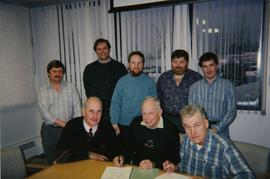
File consists of a photograph commemorating the signing of the first Aleza Lake Research Forest Management Plan. Front row, left to right: Ken Pendergast, BC Forest Service Prince George District Manager; Harry Coates, BCFS Forest Research Technician (1957-1993); John Revel, BCFS Silviculture Forester (1960-1993). Back row, left to right: Mike [?], BCFS Prince George Silviculture Manager; Henry Benskin, BCFS Research Branch; Michael Jull, BCFS Research Silviculturist, Prince George Region; Dan Lousier, BCFS Prince George Region Research Section Head; Brian Harding, Northwood Pulp & Timber Ltd. Woodlands Manager.

Salmon Valley Ranch
2012.13.2.17.19 · File · 2005, Mar. 2007
Part of J. Kent Sedgwick fonds

File consists of notes and reproductions relating to the Salmon Valley Ranch. Also includes photographs depicting the Salmon Valley Ranch.

Russian Mine Tour
2000.1.1.1.13 · File · [between 1951 and 1992]
Part of Cassiar Asbestos Corporation Ltd. fonds

Photographic negatives depict men on tour in unknown locations in Russia. Images depict urban areas, mining areas, construction of buildings, railway, mineral samples, and equipment including dump truck and electric shovel. Also includes images of area speculated to be a mine pit. Men on tour are dressed in formal attire.

Handwritten annotation in pencil on envelope containing negatives: "Russian 'Asbest' Mine Slides" "7 copies of each - 23 negatives - 161 prints".

Promotion & Outreach
2000.1.1.4.4 · File · 1963 - 1978
Part of Cassiar Asbestos Corporation Ltd. fonds

File contains photographs taken for promotional purposes.

  • Two photos depict a Cassiar display at an unknown event in 1963.
  • Eight photos were professionally taken for use in the 1978 Cassiar Asbestos Corportaion Ltd. Annual Report, and possibly other publications. These photos depict a skyscraper and products made with asbestos.
  • Additionally, two hand painted postcards of McDame Mountain and Christmas Tree House are included that may have been used for promotional reasons. Also, four slides of a display, "Story of Asbestos."
  • five photographs of unofficial tour of Cassiar via airplane in the 1970s.
2012.13.2.07.01 · File · 1994-2004
Part of J. Kent Sedgwick fonds

File consists of clippings, notes, reproductions, and letters relating to the Prince George Experimental Farm. Includes "District 'C' Farmer's Institute" letter correspondence between the director of development services and Marlene Schwartz (19 July 1999) and "RE: Century Farms Project" letter from Kent Sedgwick to the Ministry of Agriculture, Fisheries & Food (13 Sept. 1994). Also includes photographs depicting the experimental farm in Prince George, including the house on the property, a barn with a rainbow painted on the front, and the barn at multiple angles (Aug. 2001).

2007.11.4.12 · File · [between 1998 and 2007]
Part of McGregor Model Forest Association fonds

File consists of 23 posters of two sizes about the McGregor Model Forest Association and the Model Forest Network. Many of the posters are laminated and have Velcro attachments on the back for use during presentations or conferences. The information presented is varied, but includes vision statements, maps, Phase III themes and activities, recent successes, programs, information about various projects, maps illustrating model forests across Canada, phase and project objectives, information on the TFL-30 project, and information about the computer program developed by the McGregor Model Forest Association. Some simple posters advertising both the MMFA and the Canadian Model Forest Network are featured.

2007.1.45.49 · File · 1929-1958
Part of Aleza Lake Research Forest fonds

File contains handwritten cross section book, original studies with handwritten measurement charts and black and white photos, loose pages of original correspondence, handwritten diagrams and measurement charts, loose handwritten tally sheets, black and white photographs, hand coloured plot diagrams, photocopies of aerial photographs, and original correspondence for Plot 160.

2016.5.1.45 · File · 1992-1994
Part of Harry Coates fonds

File consists of several maps indicating the locations of plots and 3 detailed maps of specific plots. File also includes photographs of cleared forests and a "P.G. District Demonstration Plots: Establishment Report".

Photographs 1985-87
2016.5.4.10 · File · 1984-1987
Part of Harry Coates fonds

File consists of 47 photographs of cleared forest with some regrowth. File includes images from Prince George West - Bill's Creek 104:814: 85/87 Unit 'A'; Red Rock seed orchard July 22, 1986 Permit no. 400-360: 86/87; Mackenzie Forsar Project 86-9-9 adjacent to velpar treatment; 147-005 84/86 TFL 30 CP 5 #26; 147-008 85/87 TFL 30 CP.5 Unit 1; Northwood TFL 30 CP 12E Unit 15, Pesticide use permit #147-012:85/87.

Photographs
2022.03.01 · File · 1950-2005
Part of Stowell Forestry Collection

File contains photographs of The Pas Lumber Company Ltd. Includes other northern BC forestry industry images, including Number 5 Timber Ltd. CP625 Block 101, bridge construction, and heavy machinery. Also includes a graphic postcard of Prince George circa 1970s.

Official Tours
2000.1.1.4.1 · File · ca. 1968; 1978
Part of Cassiar Asbestos Corporation Ltd. fonds

File contains photographs depicting four different tours that took place at the mine, plant, and towns owned by Cassiar Asbestos Corporation Ltd. Tours include Prime Minister Pierre Trudeau's visit to Clinton Creek in 1968 and Member of Parliament Iona Campagnolo's visit to Cassiar in 1978. Photographs also depict a party of ambassadors touring Cassiar in 1970, and the dedication of a building in the Cassiar plant in the late 1970s.

Norway Spruce
2016.5.2.15 · File · [after 2010]
Part of Harry Coates fonds

File consists of notes, charts, and photographs showing forest management. May have been for a presentation by Harry Coates.

Northwood Spray
2016.5.4.13 · File · [1980-1999]
Part of Harry Coates fonds

File consists of photographs of "partial willow kill - good Aspen + Fireweed control 147-009 85/87" largely depicting deforested land and young trees. Some photographs are aerial photographs.

Miscellaneous Photographs
2016.5.4.18 · File · [1970-2014]
Part of Harry Coates fonds

File consists of photographs mostly depicting trees, forests, and logs. Some photos include Harry Coates. One set of photographs shows Harry Coates accepting an award.

Mine (1973 to 1991)
2000.1.1.3.16 · File · 1973-1991
Part of Cassiar Asbestos Corporation Ltd. fonds

File contains photographs featuring:

  • the pit mine: fault line, geology, snowdrifts, plowed snow, blast patterns marked by orange cones, mist, and surrounding mountains.
  • Pit mine is depicted by aerial photographs and a profile diagram.
  • Several photographs also depict what is speculated to be the portal to the underground mine adit in the early phases of development.
  • One photograph depicts the shop building in the pit mine, used for maintenance of mining equipment and to house the primary crusher.
  • Several photographs show office interiors and personnel and it is speculated that these photographs were taken in the upper floor of the shop building.
  • Several photographs depict small sinkholes in the pit mine.
  • Mining equipment depicted includes pickup trucks, front end loaders (including a Cat 988), ore haulage trucks, scoop trams, D8 Caterpillar dozer, grader, mining drill rig, jumbo drill, rock hammer, P&H excavator, and wireline extensometer. Photolab envelopes accompanying these materials were annotated “R. Tyne” and “falling ground”. Slide sleeves were annotated “Mine Nov-Dec 1975”, “AERIAL SHOTS OF MINE 1976” and “Phase 8 Dec 1975”.
  • Photographs of a Gardner Denver blasting drill at the mine and other ground drills working
  • Photograph of proposed power line to #1 switchback in 1975,
  • Collection of photographs of a Wsbco truck with corresponding mechanical transfers of those photographs.
  • Also photographs a Gardner Denver drill and a Bucyrus Erie drill that was rented to Cassiar Mine in 1974. This collection includes a depiction of an accident with these drills.
  • An additional collection of photographs of #709 Drill that was involved in minor accident. A pipe was either damaged or was the cause of the accident.
  • Negative collection of photographs with corresponding notes of descriptions.
  • Photographs of G.D. 80 Drill - Blasthole drill at work in the open pit.
  • Photographs part of Month End Reports from January - June 1980
  • Photographs of portable toilets used on Mine site.
  • Photograph collection of mine garage January 21, 1988
  • Photograph collection of what is believed to be the inside of the mine garage and various storage units and equipment. Marked "Receiver File" in original enclosure.
  • Photos of Crane in 1984.
  • An Album of 192 photographs of machinery in March of 1976 working at the mine site. Some of the equipment from either the plantsite or the mill is also depicted.
Mine (1952 to 1972)
2000.1.1.3.15 · File · 1953 - 1970
Part of Cassiar Asbestos Corporation Ltd. fonds

File contains photographs depicting machinery, individuals, buildings, and mining processes at the open mine on McDame Mountain, Cassiar, B.C. Some photos depict benches from open strip mining, and two images feature models of the mine (1955 and 1970). Machinery depicted includes shovels, bulldozers, tractors, ore haul trucks (Kenworth, International Harvester, and Wabco), air track drills, blasthole drills, and Ingersoll-Rand Drill. Identified individuals include Fred Murray, R.R. [Kiresan?], C.E. Bronson, Bill Giachino, and "Sam".

2000.1.1.2.11 · File · 1986 - 1989
Part of Cassiar Asbestos Corporation Ltd. fonds

This file includes two major photographic collections concerning the construction and development of the underground mine at Cassiar, title the McDame Project.

The first collection includes fifteen monthly progress reports documenting the development from July 1988 to December 1989. The progress reports are authored by G. Verret, and were distributed to the executives of Cassiar Asbestos in Vancouver as well officials of the B.C. Government and other creditors of the Corporation. Most images are annotated and dated. Many of the loose photographs are accompanied by an inventory sheet.

Subjects depicted include: the staging area prior to mine development, the initial development of the “Vent Portal”, a jumbo drill working on the mine face, the working face marked for drilling and wired with fuses, a Caterpillar dozer clearing snow after an avalanche, scene of a fire in winter time, complete conveyor sump decline, mining vehicle parked on the “Lay-Down Area” presumably near the portal, the working face of the mine at various stages of development, 1563 portal being slashed, the removal of the overburden for the tramline loading station site, the construction of the transfer tower(s), construction of the stockpile area, the construction of a sedimentation pond, a presumed cave in, construction of footings for the conveyor, construction of the tramline loading terminal station, construction of the crusher building, a slash titled “Breakthrough in Access Ramp”, storage of powder and fuses, a washout in conveyor decline, fog at the portal in -30 degrees Celsius, the 1290 junction flooded, a slab of shotcrete which fell on and injured a miner while shotcreting, shotcrete blasted off walls for repairs, images of the “Hilti-test”, shots showing grade of drift, and structural failures in the 1350 adit.

Locations and structure within the underground mine depicted include: yellow ventilation ducting, ground support including steel screen and shotcrete, steel cables bolted unto ground support, puddles in the adits, the access road to the lay-down area, the exhaust drift, “Fans and Heaters in the 1415 adit”, the 1350 sump, the access ramp to the 1320, the exhaust ramp safety bay, the conveyor decline, the ventilation adit, the 1563 portal, the temporary repair shop at the 1415 portal, junctions of various drifts, the ”Fresh Water Pump & Pumphouse on lower Creek”, the “Ventilation Raise/1563 Platform”, a “Diamond Drill Station” at 6066 North in the underground mine, the “Bridge to the Gravel Pit”, the “Crushing and Screening Plant” in the gravel pit, the ventilation bulkhead in the conveyor decline, and the “Powder Magazine”.

People depicted include Rose Gay and R. Tyne on a tour of the underground mine, a geologist with a rockhammer, a miner identified as A. Jacobs working, contract miners Bruno and Marbel from Canadian Mine Development, and unidentified miners rockbolting, shotcreting, and drilling using jackleg drills.

Vehicle and mining equipment depicted include jeeps, pickup trucks, a front end loader, an unidentified a small unmanned tracked machine with a long arm, scoop trams, a land cruiser, an ore truck with a flat tire, the cone crusher, a “scissor lift”, a mobile shotcrete machine, a new grout pump, a new Boart Jumbo Drill, and a detached bucket half of a 413 ore truck.

The second collection depicts the McDame Project construction in 1986 and 1987.
Content of these photographs includes: various machinery used for excavating and drilling, underground progress of tunneling, supports, wire meshing, rock formations in mine, and exposed asbestos. There are no annotations regarding this photographs.

Landslides
2000.1.1.3.06 · File · 1979 - 1989
Part of Cassiar Asbestos Corporation Ltd. fonds

File contains images depicting various landslides near Cassiar BC. Set of 20 photographs (with 9 corresponding negative strips) date stamped June 1987 depict landslide near creek and dirt road with a Cassiar company truck. Set of 5 black and white photographs found in envelope marked "D. Stewart" are likely from 1988-1989 and depict a rockslide on the south western side of the pit mine, near the tramline. Album entitled “6200 DUMP SLIDE / SPRING, 1979” contains 34 photographs depicting aerial shots of a massive rockslide on the eastern slope of McDame Mountain, originating from the mine waste dump. Several images from album show greenish water pooling in the toe of the slide.

2023.2.2.13.2 · File · Jul. 2007
Part of Dr. Paul Sanborn fonds

These images were obtained on the helicopter flights to and from the Klutlan Glacier study site. The outbound sequence (#5590-5706) starts from the base camp at the White River crossing on the Alaska Highway and heads south, to a point just upvalley of the debris-covered terminus (approx. 10-15 km from Alaska border), and turning back north to the landing spot on the Generc River floodplain close to the study site (see Fig. 1 in paper). On the return leg at the end of the day, the flight initially went upvalley to pick up another party (#5884-5926), before turning north and returning to base camp (#5929-5993).

2023.2.2.8.15 · File · 2004
Part of Dr. Paul Sanborn fonds

Slide roll contains the following photographs:

Y04-19 (27.5 km on Cultus Bay Rd., near Thorsen Bay)
Date: July 22, 2004
Location Coordinates: 61º 12’ 3.0” N, 138º 28’ 58.3’ W, 819 m asl (± 18.9 m)
Site Description: Roadcut at base of 30º, E-facing slope. Colluviated loess overlies sandy glaciofluvial at 120 cm. Prominent paleosol with “cumulic” B horizon at 80-120 cm, with strong effervescence throughout exposure.
Sample Depths & Descriptions: Y04-19-01 – charcoal at 95 cm
Roadcut opposite ~ 30 m to NE on grassy S aspect (10° slope) with 15-20 cm of calcareous loess and sand over 2 cm White River ash; strongly effervescent throughout.
Slide roll 7, #36-35 (profile)
Corresponding prints and negatives: Print roll 11, #11A-12A (profile)

Thorsen Bay landscape
Slide roll 7, #34-32
Corresponding prints and negatives: Print roll 11, #13A-16A

Y04-20B
Date: July 22, 2004
Location Coordinates: 61º 10’ 16.5” N, 138º 26’ 18.7’ W, 797.5 m asl (± 5.9 m)
Site Description: wind-eroded Slims soil on glaciolacustrine with contorted bedding (exposed on blown-out roadcut); calcareous to surface; White R ash pockets at 10-20 cm; S aspect, 5° slope.
Slide roll 7, #31-26
Corresponding prints and negatives: Print roll 11, #17A-21A

Y04-22
Date: July 22, 2004
Location Coordinates: 61º 9’ 39.24” N, 138º 25’ 7.8’ W, 790.6 m asl (± 6.4 m)
Site Description: toe of 30° slope, W aspect (grassy slope with poplar at toe); 1.0-1.2 of colluviated loess over gravelly glaciofluvial with buried soil at 70-80 cm
Slide roll 7, #25-24
Corresponding prints and negatives: Print roll 11, #22A-24A

Cultus Bay Rd.
(landscape views looking W from road; lake is likely at ~61°4’ 10.5”N, 138°22’ 31.5”)
Slide roll 7, #23-22
Corresponding prints and negatives: Print roll 12, #0A-2A

Y04-26 (EW)
Date: July 23, 2004
Location Coordinates: 61º 1’ 59.8” N, 138º 21’ 53.6” W, 836.1 m asl (± 7.7 m)
Site Description: grassland at crest of 33° terrace scarp, S aspect.
Sample Depths & Descriptions: Y04-26-01 – 0-10 cm
Slide roll 7, #21-20
Corresponding prints and negatives: Print roll 12, #14A-15A

Y04-27
Date: July 23, 2004
Location Coordinates: 61º 2’ 0.9” N, 138º 21’ 53.6” W, 843.6 m asl (± 5.8 m) (~ 35 m N of Y04-26)
Site Description: spruce forest on terrace surface; level.

  • 0-8 cm - Loess-rich forest floor; strongly calcareous.
  • 8-13 cm - Bmk
  • 13-15 cm - Discontinuous pockets of White R ash
  • 15-35 cm - Bmk (Slims soil) – no charcoal visible
  • 35-75 cm - Gray calcareous loess.
  • 75 cm+ - Gravelly sandy glaciofluvial deposit.
    Slide roll 7, #19-18
    Corresponding prints and negatives: Print roll 12, #16A-17A

Y04-28 (EW)
Date: July 23, 2004
Location Coordinates: 61º 2’ 34.4” N, 138º 21’ 57.0” W, 820.2 m asl (± 6.1 m)
Site Description: grassland on esker crest W of Jenny L; 30° slope, SW aspect
Sample Depths & Descriptions: Y04-28-01: 0-10 cm
Slide roll 7, #17-16
Corresponding prints and negatives: Print roll 12, #18A-19A

Y04-30 (between eskers, W of Jenny Lake)
Date: July 23, 2004
Location Coordinates: 61º 2’ 31.6” N, 138º 21’ 52.3’ W, 817.6 m asl (± 6.1 m)
Site Description: Level (base of saddle). Colluviated loess to 90 cm+, with White River tephra at 15-17 cm, brownish paleosol at 17-35 cm, underlain by turbated Bmku with multiple charcoal-rich bands.
Sample Depths & Descriptions:

  • Y04-30-01 – charcoal at 13 cm (above WR tephra)
  • Y04-30-02 – charcoal at 22 cm (below WR tephra)
  • Y04-30-03 – charcoal at 75 cm
    Slide roll 7, #15-13
    Corresponding prints and negatives: Print roll 12, #20A-22A

Y04-31 (EW)
Date: July 23, 2004
Location Coordinates: 61º 3’ 9.2” N, 138º 21’ 30.3’ W, 837.2 m asl (± 6.4 m)
Site Description: crest of N-S esker ridge
Sample Depths & Descriptions: Y04-31-01: 0-10 cm
Slide roll 7, #12-11
Corresponding prints and negatives: Print roll 13, #1-3

Y04-32
Date: July 23, 2004
Location Coordinates: 61º 3’ 7.4” N, 138º 21’ 27.7’ W, 823.7 m asl (± 13.7 m)
Site Description: toeslope on NE side of same ridge as for Y04-31; 20° slope, NE aspect; Cryosol with permafrost at 34 cm; 30 cm of forest floor organic horizons; abundant charred wood fragments at top of mineral soil & in lowest part of organic horizon.
Slide roll 7, #10-9
Corresponding prints and negatives: Print roll 13, #4-5

Y04-34
Date: July 23, 2004
Location Coordinates: 61º 3’ 47.7” N, 138º 21’ 2.5’ W, 838 m asl
Site Description: Toe of 30º, W-facing grassland slope. Colluviated loess with White River tephra at 8-9 cm, brownish paleosol (9-35 cm), overlying sandy glaciofluvial at 35-70 cm+.
Sample Depths & Descriptions: Y04-34-01: charcoal at 34 cm
Slide roll 7, #8-7
Corresponding prints and negatives: Print roll 13, #6-7

Y04-35 (EW)
Date: July 23, 2004
Location Coordinates: 61º 3’ 49.9” N, 138º 21’ 1.1” W, 854.4 m asl (± 6.3 m)
Sample Depths & Descriptions: Y04-35-01: 0 – 10 cm
Slide roll 7, #6-5
Corresponding prints and negatives: Print roll 13, #8-10
(Location not recorded: Print roll 13, #11-12)

Y04-36
Date: July 23, 2004
Location Coordinates: 61º 8’ 11.5” N, 138º 25’ 50.8” W, 825.6 m asl (± 14.5 m)
Site Description:

  • 10-0 cm - LF
  • 0-15 cm - Bmk1 (7.5YR 4/6 m)
  • 15-28 cm - Bmk2 (2.5Y 4/3 m)
  • 28-48 cm - Ck
  • 48-55 cm+ - IICk (sandy gravelly glaciofluvial)
  • No charcoal visible in mineral horizons
    Slide roll 7, #4-3
    Corresponding prints and negatives: Print roll 13, #13-14

Y04-37
Date: July 23, 2004
Location Coordinates: (roadcut adjacent to Y04-36)
Site Description: multiple colour bands in Slims soil; some charcoal blobs (not sampled) which are right size to have been roots.
Slide roll 7, # 2-1
Corresponding prints and negatives: Print roll 13, #15-19