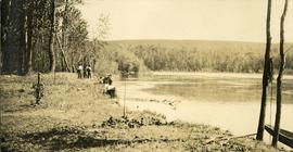
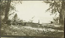
Photograph depicts man reclining against one of three tents. Picnic table and trees in foreground, water in background.
Image depicts numerous piles of wood planks at the Canadian National Railway Yards in Prince George, B.C. The cutbanks are seen in the background.
Photograph depicts a view from rocky river banks looking toward a Canadian Pacific Railway bridge.
Image depicts the BC Packers Ltd. cannery in Prince Rupert, B.C.
Photograph depicts an empty canoe floating directly in front of small white tents on opposite shore. Forest trees in background.
Handwritten caption beside this photo reads: "I built this boat." Photograph depicts canoe and paddles afloat in water, grassy shore in foreground. A pair of pants can be seen in boat, as well as wood planks, box, and rope on shore.
Image depicts a church and several other buildings in Canoe Creek.
Image depicts a house located somewhere in or near Canoe Creek.
Image depicts a view of Canoe Creek.
Photograph depicts a small pass through an island or peninsula on the Fraser River. Photo is believed to have been taken near Stone Creek, south of South Fort George. Annotation on verso of photograph reads: "FORT GEORGE CANYON. CANOE PASS. J. HEAY. PHOTO."
View of Pier and cluster of houses with trees in the background. Water crosses midground, canoes on beach in foreground. Printed annotation on verso reads: “Port Simpson.", handwritten in pencil: “B.C. 1907”.
Riverboat floats in midground, canoes float by shore. Trees and hillside on opposite shore in background. Poor image quality.
Canoes sit on shore in foreground beside village buildings. A dock is visible above water in background.
Handwritten annotation on verso reads: "Alert Bay Indian Ranch No. 14 Alert Bay. To be shown on page 69 or 70, re Alert Bay Mission."
Photograph depicts seven or more persons, some standing on river bank with ropes, some standing in a loaded canoe with poles, forest in the background, grass, river shore and anchored boat in foreground.
Photograph depicts four men paddling a long canoe. The canoe is loaded with supplies and a dog, river and forest in the background.
Photograph depicts an unknown canyon. It may be located in the area of Cheakamus Canyon near Squamish.
Photograph depicts steep canyon wall with a river below, low mountains in the distance. Survey of 55th parallel.
Image depicts a view of the ridge above the Fraser River which forms the Grand Canyon, B.C.
Photograph depicts a view from below, looking up at a suspension bridge. Three or more people are walking on the bridge. There is a forest and building in the background.
Photograph depicts a walkway view of a suspension bridge. Several people are walking on the bridge.
Image depicts a car on a dirt road leading through a forest.
Image depicts Bennett Lake near Carcross, Y.T.
Image depicts a log house at an uncertain location; the slide is simply labelled "Cariboo."
Image depicts the Cariboo Falls.
Image depicts the Cariboo Lake, with the roof of an old log cabin visible.
Image depicts the Cariboo River.
Image depicts the old, grown-over Cariboo Road at an uncertain location.
Image depicts the Cariboo Road south of Williams Lake.
Image depicts the Cariboo Road at Hat Creek Ranch, near Highway 99 on the way to Lillooet.
Image depicts the Cariboo Road in Soda Creek, B.C.
Photograph depicts a road bordered by people, building and fences.
Photograph depicts a road bordered by people, building and fences. A stage coach is situated on the side of the road.
Handwritten annotation on verso of photograph: "Early Days on the Cariboo Road. No. 8." Photograph depicts man driving two covered wagons pulled by team of six horses on gravel road. Valley crosses midground, hills in background. Handwritten annotation on recto of photograph: "H. F. Glassey Esq. P.O Box 950 Prince Rupert B.C. Dear Bert: We have been kept very busy have been on committee work all through the convention but it was wonderful will write you a long letter from Vancouver. Mrs Earley wants me to stay until Monday morning train. Met Mr. [Colley?] everything going fine here. I am sure you are busy [...?] Love from Sadie. Mr & Mrs. [Graif?] are living here."
Photograph depicts two, four-horse stagecoaches laden with passengers parked outside the Hotel Northern in South Fort George. A group comprised of primarily men watch the stagecoaches from the veranda of the hotel. Handwritten annotation in bottom right corner of photograph reads: "Cariboo Stage at South Ft. George, BC. Oct 19-1911."
Photograph depicts a caribou head, velvet antlers intact. Head is resting in a snow patch, two men and alpine forest in the background.
Image depicts a small slope on Carney Hill in Prince George, B.C.
Image depicts two boats on the shore of Carp Lake.
Image depicts a campsite on the shore of Carp Lake.
Image depicts Carp Lake at dusk.
Image depicts a green canoe sitting in the water on the shore of Carp Lake.
Image depicts a man holding a chain of fish on the shore of Carp Lake.
Image depicts a low rain cloud over Carp Lake.
Image depicts a low rain cloud over Carp Lake, and a man on a boat on the lake.
Photo depicts a street perspective cars lining Third Avenue, in Prince George, BC, ca. 1950. Annotation recto reads: "3rd Ave Prince George BC Photo J. Wrathall." Handwritten annotation in pen on verso of postcard reads: “This is the equivalent of our Granville Street. Both theatres are located here as well as Hudson Bay Co., banks, library & stores.”
Street view photograph looking down Carson Avenue at the Front St. intersection in Quesnel, BC. Several identified businesses line the gravel avenue on the right; however Cowan's Hardware store is visible at the intersection on the left. Printed annotation on recto reads: "Carson Ave., Quesnel, B.C. 1930 Looking East."
View of snow capped mountains in the distance, vast rolling treed hills in mid ground and a gravel road in the foreground. Road sign indicating severe curve in road situated at the right of the gravel road. Handwritten annotation on verso in pen reads: “Cassiar – Stewart highway”