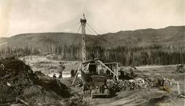
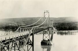
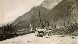
Photograph depicts a bridge construction site, including a truck, a dirt pile, stacks of cut logs, and people, two of whom are on the top of a tall tower anchored by many wires. An engine is behind the truck. The truck has a flat deck with wood slat sides. A machine is visible on the far right of the photo with the numbers 261 written on one part and obscured numbers are on another part. The river valley is treed, and construction is visible on both banks. The location is believed to be in Northern British Columbia or Yukon Territory, between Fort St. John and Whitehorse.
Photo depicts a large white building in the right foreground with smaller buildings beyond it. A group of metal silos is at the left of the photo with a small unfinished lean-to in front of it. Trucks, trailers, and cars throughout the photo and two long, low buildings in the trees. Mountains with snow on them in the background. Power lines connect throughout the camp.
Photograph depicts multiple wooden buildings on the shore of still water. Deciduous trees line the shore and the area around the structures has been cleared. Still water shows reflection of trees and cabins. Photos depict a distance of water suggesting the waterfront is on a lake or a slow, wide river.
Photo depicts many simple, long buildings set amongst trees in front of a rounded mountain with two trucks. Sign visible but illegible on the roadside near the buildings. Buildings appear unfinished with batten and no boards.
Photograph depicts a crane on a track with a load of lumber on a wide bridge that is under construction. A vehicle is seen from the rear beyond the crane with people beside it. Two people are visible next to the crane. Sandy cutbank and low mountains at the river edge.
Photograph depicts an unknown river on which bridge construction is taking place. A 1940s era truck is elevated by wires and tackle, presumably from a crane (not in image). The location is believed to be in Northern British Columbia or Yukon Territory, between Fort St. John and Whitehorse.
Photo depicts and empty gravel road that follows a dip down, then rises to disappear into a line of deciduous trees. Low, rounded mountains flank it on the left and a line of power poles flanks it on the right. The bumper of a car takes up the right edge of the photo suggesting the photo was taken from a low vantage point.
Photograph depicts a wooden ferry crossing a river. At least four horses are tied nose to nose at the centre of the ferry and six men are visible at the edges of the ferry and the back. The river valley is treed, and a truck is visible on the far bank. The location is believed to be in Northern British Columbia or Yukon Territory, between Fort St. John and Whitehorse.
Photograph depicts a woman in a dark pleated skirt and a hat with a dark, shiny brim, standing at the driver's door of a car with the words District Engineer, Dawson Creek, B.C., U.S. Army Engineers, Construction Division on a white sign on the door. Handwritten in blue ink on the photo are the words Yours truly Audrey Uday "First Chauffeurette on Alaksa Highway." Buildings and vehicles in the background.
Photograph depicts five trucks in a row along a road under construction with five persons standing beside the lead vehicle. Snow has been cleared from the road into piles above a valley. The location is believed to be in Northern British Columbia or Yukon Territory, between Fort St. John and Whitehorse. The trucks have holding tanks. The third vehicle has a trailer with a second holding tank. The first vehicle has the front door open on which the letters G SPASOFF are written.
Photo depicts a river valley with tall, rounded, treed mountains with snow on the peaks and in the ridges and runnels. A gully takes up the foreground of the photo, maybe caused by a landslide or by glacial retreat. Sandy cutbanks, skinny trees, and snow line the gully or ravine.
Photograph depicts a waterfall partially sheeted in ice. The river right portion of the ice is still intact, and the main flow of water is covered only by a bridge of ice that links both shores. A person with their face covered by a mask or balaclava is in the foreground next to a log jam. Open water flows behind them. Trees are seen above and beside the waterfall.
Photo depicts a frozen shore with a dock or ferry frozen into the ice, which tilts the construction. A ramp is angled onto the dock or ferry. Low, round, treed mountains flank the water on the left and a treed shore with small sheds is on the right. Logs and ice chunks in the foreground.
Photo depicts a valley bottom that is either an empty lakebed or a frozen lakebed. Rocky and treed cliff on the right of the photo and snowy, treed mountain on the left. Faded mountains at the end of the lake form a horizon.
Photo depicts a log landing and possible sawmill site with stacks of limbed logs, a tent structure, a sawdust pile, and a log house in the mid-ground with treed mountains beyond. An open bar or warehouse with doors wide is behind an empty flatbed truck and trailer. Logs stacked in something of an order in the foreground with what looks like a simple bridge structure laid out.
Photo depicts a bridge under construction. Construction of girders and decks is begun on the left and right banks that reach out into the river, but the middle section is yet to be built. Ice is visible on the shores of the river and in the foreground. Low mountains in the background and wood debris and driftwood in the foreground.
Photo depicts a truck on a sandy foreground marked up with tire tracks. A group of people gather to the side of the truck, forest and low mountains in the background. Truck door is open.
Photo depicts a muddy road in rough repair with water coursing down it and deep tire ruts beside a wide river. A mud bank with downed logs and trees is seen on the left and an unfinished bridge structure is on the right. In the middle of the photo, possibly stuck in the mud, is a truck with a tarped load, two men beside it, and a tractor behind it.
Photograph depicts a bend in a creek from water level. The location is believed to be in Northern British Columbia or Yukon Territory, between Fort St. John and Whitehorse.
Photograph depicts the construction of the Peace River suspension bridge. Two towers of the bridge are visible. The roadway of the first span is unfinished. The bridge crosses the Peace River.
Photograph depicts a vehicle seen from behind on a plowed, snowy road likely in Northern BC. Steep, snowy grade on the left of photo and tall trees on the right. Mountains can be seen in the distance.
Photograph depicts a road under construction on which two men are seen crouched to attach limbed trees with chains to the truck and a third observes, standing. A crane is seen beyond the truck. Piles of debris from timber falling and standing timber line the roadway. The road follows the base of a mountain range. The location is believed to be in Northern British Columbia or Yukon Territory, between Fort St. John and Whitehorse.
Photograph depicts two vehicles and earth moving equipment. One person is seen next to a vehicle, and one person is halfway up the mountain in a dug-out area. The mountain is sparsely treed, perhaps snow in the foreground.
Photograph depicts a road under construction beside a river in a valley. Power poles line the road bed on one side. Steep cutbanks on the river can be seen. The location is believed to be in Northern British Columbia or Yukon Territory, between Fort St. John and Whitehorse.
Photograph depicts three vehicles on a muddy landing in front of wooden buildings - a truck with a wooden truck bed, an engine with treads attached by wire towing another vehicle. A person can be seen walking in mud in the right third of the image. Two trucks with covered truck beds can be seen further back. The location is believed to be in Northern British Columbia or Yukon Territory, between Fort St. John and Whitehorse.
Photo depicts a snowy road leading toward a distinctive low mountain or butte with a cliff that ends in a slight overhang like it's had a bite taken out of it or a half-moon shape. Mature deciduous trees with blowdown at the road edge. A truck with a liquid load tank and a snowy spare tire is seen from the rear parked next to the plowed road edge.
Photograph depicts a white sternwheel boat moored at the edge of a river adjacent to a bridge.
Photo depicts three men in front of two long buildings. Horizontal battens are visible on the buildings which have not been clad with siding and are lined with many small windows. A ladder goes up the side and onto the roof of each building where the side wall meets the front wall. The men wear rolled up, belted, high-waisted pants, works shirts, and have their hair slicked back. The man in the middle has his arms around the others with his hands resting on their shoulders. All are smiling.
Photograph depicts transport truck with trailer in snow. Crane and other vehicles in the background, some rope and concrete in the foreground. Power poles visible beyond the truck. Back of truck appears loaded, trailer less so.
Photo depicts a long line of trucks on an unfinished dirt road in a forest. Trucks are tarped army trucks or transport trucks. Two men visible on the road, one seated on wood debris from logging at the roadside. One man wears a cap beaked cap, and one wears a fedora.
Photo depicts three trucks and transport trailers parked end to end in a snowy landscape. Three men lean against the front and side of the first truck. Deciduous trees are seen in the background. The trailers are empty, or no loads can be seen in the trailers.
Photograph depicts five tall pines in the foreground, a treed expanse, then water (unclear if river, lake, or inlet). And island is seen to the left of the central pine and two islands are behind it. Mountains descend right to the water on the right horizon. A line across the horizontal centre of the photo may be discolouration or may depict a storm/rainclouds advancing.
Photograph depicts three snowy mountains seen from a roadway. One is a long ridge, one is a rounded peak, and one is a lesser ridge. A treed ridge with a small peak appears as a front range. The location is believed to be in Northern British Columbia or Yukon Territory, between Fort St. John and Whitehorse.