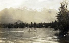
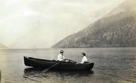
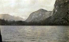
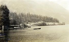
Photograph depicts a couple in a row boat (likely the same couple depicted in image 2020.08.59) near Alta Lake shore docks and buildings. A rail line and a railway water tower are visible in the background. The water tank is a typical PGE 25,000 gallon water tank. The station would be a little over 400 feet south of the tank and is hidden by the stand of trees.
Photograph depicts a railway water tower, a small building, and a rail line along a lake shore. This is a close-up of the area depicted in image 2020.08.84. The water tank is a typical PGE 25,000 gallon water tank. The station would be a little over 400 feet south of the tank.
Photograph depicts the "Big Slide" at Lillooet. Also visible are a horse-drawn cart and the Fraser River.
Photograph depicts a man and a woman in a row boat on Alta Lake.
Photograph depicts the waterfall Brandywine Falls.
Photograph depicts an unknown canyon. It may be located in the area of Cheakamus Canyon near Squamish.
Photograph depicts a horseback rider crossing Cayoosh Creek at a log bridge near Lillooet.
Photograph depicts the Cheakamus River at "18 mile", as seen from the railway grade.
Caption provided on "real photo" postcard states: "Cheakamus River from bridge". However, this photograph may depict the Cheekye River, as seen from the railway bridge, looking southwest.
Photograph depicts two children in a row boat on an unknown lake in BC. Buildings can be seen along the shore in the background.
Photograph depicts Shannon Falls near Squamish, which was formerly named Fairy Falls.
Photograph depicts a view of fog over the Fraser River in the Lillooet area.
Photograph depicts a view of mountains, described as the head of Cayoosh Creek near Lillooet, BC.
Photograph depicts a view of a river, possibly the Fraser River, canyon, mountains, and scrub land.
Photograph depicts the Mamquam River near Squamish.
Photograph depicts a view of the Fraser River, scrub land, and mountains in the Moran Canyon area near Lillooet.
Photograph depicts a view of Mt. Garibaldi, possibly from Brackendale.
Photograph depicts a view of Squamish, which was named Newport between 1911-1914. This photograph was taken from the Squamish Smoke Bluffs, looking south. Mamquam River blind channel visible in foreground.
Photograph depicts a view of the Pacific Great Eastern Railway bridge across the Fraser River at Lillooet.
Photograph depicts a view of the Pacific Great Eastern Railway bridge across the Fraser River and the nearby Lillooet surrounding area. The photograph shows Lillooet looking up Town Creek Valley. Chinese gold washing activity is visible nearby the bridge.
Photograph depicts the Pacific Great Eastern Railway line at Pavilion looking south. An irrigation ditch line is also visible.
Photograph depicts a view of a train on the Pacific Great Eastern Railway line approximately 2 miles south of the Pavilion station.
This collection consists of photographs and "real photo" postcards that depict the construction and operation of the Pacific Great Eastern Railway line, communities nearby the railway line, and regional geography of areas adjacent to the PGE line.
Photograph depicts a Pacific Great Eastern Railway train on Pavilion Creek trestle at Mile 20.3. Also visible are a water tank and possibly the graveyard at Pavilion.
The ca. 1921-1927 “PGE Bridge List” from the notebook of William H. Hewlett (1914-1968) references a 389.4 foot long, 34 ft. high, framed trestle with 26 spans of 14.8 feet at Mile 20.3 carrying the line over Pavilion Creek. There was a water tank at Pavilion located between the North end of the siding and the South end of the trestle. A track profile chart confirms that the track at this point is on a 12 degree curve. This photograph was taken from a vantage point up the hill to the North. The structures at the lower left of this image (2020.08.82) are consistent with a small construction camp, which accounts for the presence of a camp cook in image 2020.08.83.
"Canadian Railway and Marine World" reported in their January 1916 issue (p. 11, c.1), that track had been laid to within ½ mile of Clinton (Mile 45.0) on Dec. 14, 1915. If a constant rate of construction had been maintained from Mile 14, reached on July 30, 1915 as previously discussed, to Clinton, the approximate date of completion to Pavilion would be around the end of August, 1915 which is probably the earliest possible date for this photograph.
Photograph depicts "Kelly's Lake" (now known as Kelly Lake) in Clinton, as well as the Pacific Great Eastern Railway line along the lake.
Photograph depicts the east end of Seton Lake near Lillooet.
Photograph depicts a view of the east end of Seton Lake. The Seton Lake sawmill and Seton Lake fish hatchery are visible in the foreground. The PGE railway grade alongside the lake has not yet been constructed, dating this photograph at or before 1914.
Photograph depicts a view of Seton Lake taken at Retasket, looking towards Lillooet. Retasket was a whistle stop siding on the Pacific Great Eastern Railway line.
Photograph depicts the steam-operated Durban & Sons sawmill at the east end of Seton Lake. This photograph was taken before the PGE railway grade was built alongside the lake circa 1914-1915.
Photograph depicts the steam-operated sawmill at Seton Lake and a fish weir at the mouth of the creek. The railway grade alongside the lake, constructed circa 1914-1915, is visible in the background. The Seton Lake fish hatchery, which built and used the fish weir, ceased operations in 1915, dating this photograph sometime around 1914 or 1915.
Photograph depicts a view of "The Captain" mountain near Lillooet, BC.
Photograph depicts the Upper Canyon, Cheakamus River. The photograph was likely taken from the railway grade at approximately "20 mile", looking north.
Photograph depicts the Upper Cheakamus Canyon, likely taken from above the railway grade at about "19 mile" looking north.
Photograph depicts the confluence of the Cayoosh Creek outflow into the Fraser River in Lillooet, BC. Seton River is visible in the foreground. This area is Cayoose Creek Band (Sekw'el'wás First Nation) territory and includes land currently encompassed within Cayoosh Creek Indian Reserve 1. The Pacific Great Eastern Railway bridge over the Fraser River is also visible in the background.
Photograph depicts a view of the Lillooet Indian Reserve in the foreground; the town of Lillooet and the Fraser River are visible beyond.
Photograph depicts a view of a train crossing the Sallus Creek wooden trestle along the Pacific Great Eastern Railway line near Lillooet, Fountain, and Pavilion. The angle of the photograph is looking north towards the Fraser River.
Photograph depicts a view of Seton Lake and the surrounding area, including the Pacific Great Eastern railway line. The railway grade is visible at left. Also visible is the Seton Lake fish hatchery at the east end of the lake and its employee boarding house, superintendent's cottage, and weir at the head of what was then referred to as "Lake Creek". The road seen in the centre foreground travelled from Lillooet to Seton Lake then to Golden Cache Mine.
Photograph depicts a view of St'a7mes village looking north, taken from the original Government Wharf in Squamish (Newport). This wharf was built in 1902 and was temporarily replaced by other docks to the west built by the PGE Railway in 1913-14. This photograph was taken after 1914, since the houses in the photo were built by the PGE Railway Company as part of the 1914 reserves sale deal.
Further details that date this photograph between late 1914 and 1920:
- the Merrill & Ring logging operation beach camp is not depicted (opened in 1926)
- the dock from which the photo is taken fell into disrepair after 1914 and was not rebuilt until 1929.