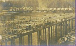
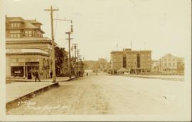
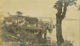
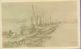
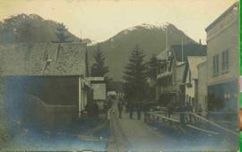
Photograph of a boardwalk street with buildings on either side, several people visible in image. Trees can be seen on street, and mountains stand in background. Handwritten annotation in pencil on verso reads: “Port Essington, North Coast Commercial Coy”.
View of dock full of rows of nets and a few workers. Sail boats are anchored near the dock and there are rows of bunkhouses in the mid ground, trees in the background. Handwritten annotation in pencil on recto reads: “Port Essington B. C.”
View of peninsula with houses and trees. Dock in mid ground, trees and grasses in foreground. Recto stamped “Port Simpson DE 17" and "Port Essington DE 18". Handwritten annotation on recto of photograph: "W. J. O'Neill Esq. Telegraph Point Via Pt. Essington B.C. Don't you think this pretty [Weggs & Mr. Byron?] was over last night - said he saw you and [Halie?]. Yours - BaBa".
View of Pier and cluster of houses with trees in the background. Water crosses midground, canoes on beach in foreground. Printed annotation on verso reads: “Port Simpson.", handwritten in pencil: “B.C. 1907”.
Side perspective of the Quesnel Lake Lodge. The building is in very good condition, and is surrounded by many trees. Printed annotation on recto reads: "Quesnel Lake Lodge, Likely, B.C."
Photograph taken from a small hill looking down on a crowd of men gathered around the Grand Trunk Pacific railway tracks in the winter. Printed annotation on recto reads: "Linking up of Steel on G.T.P. Transcontinental 1914."
Photograph depicts Hotel Fort George with people, cars and power pole in foreground. Handwritten annotation on verso reads: “Hotel Fort George - 1913”.
Street scene showing people, dog, team of horses & wagon. Signage reads: “Beds; Mecca Café; Hardware.” Printed annotation on recto reads: “Hamilton Avenue, South Fort George, B. C. No. 110.” Verso displays cancelled 1 cent Canadian Postage Stamp and handwritten message in ink is addressed to Mr. Eathan Villard Burt Mish, U.S.A.
Photograph of Prince George Hotel with several early model cars and a few people. Printed annotation on recto reads: “Hotel Prince George, Prince George, B. C.”
Overhead view of commercial buildings in downtown Prince George. Printed annotation on recto reads: "Prince George, B.C."
Photograph taken from the intersection of 3rd Avenue and an unidentified street. Visible businesses include "Ben Baird The Smart Shop" and "C.N.R. Cafe." Printed annotation on recto reads: "3rd Ave. PR. George, B.C."
Aerial view of Prince George and surrounding forested area. Printed annotation on recto reads: "Prince George, B.C."
Wide angle photograph of a forested area with Prince George in the distance. Printed annotation on recto reads: "Prince George, B.C. 1924."
Photograph depicts crowds of people walking through street, hills in background. Printed annotation on recto reads: “Centre St. Prince Rupert May Celebrations 1909, Allen Photo July 09.” Handwritten annotation in ink on recto reads: “Prince Rupert 1909”
Buildings in foreground, waterscape in midground, trees and snowcapped mountains in background. Printed annotation on recto reads: “Marine and Fisheries Digby Island Prince Rupert B.C. McRae Bros”
Lofty view of Prince Rupert BC. Water crosses midground, hills and opposite shore in background. Printed annotation on recto reads: “Prince Rupert BC McRae Bros”.
View from of a large ship in dry dock surrounded by water. Printed annotation on recto reads: “G.T.P. Dry dock Prince Rupert B.C. McRae.”
People, cars, and trucks visible on street, buildings in background. Handwritten annotation on verso reads: “P. Rupert Main Street British Columbia Canada, McRae Bros".
Parade of uniformed marchers with sign that reads: “Every little helps, Do your share” (with a large cross). Buildings on street in background. Printed annotation on recto reads: “Prince Rupert B.C.” Handwritten annotation in pencil on verso reads: “Prince Rupert B.C.”
View of large houses on hill and city streets below. Printed annotation on recto reads: “Prince Rupert Residences on Cliff Which Runs Thru the Heart Of the City”.
Side perspective street view of Prince Rupert Post Office, as well as neighbouring buildings including the Prince Rupert Bazaar. Printed annotation on recto reads: "Post Office Prince Rupert B.C." Unidentifiable photographer's stamp is on lower right corner.
Slightly elevated street view of several Prince Rupert storefronts. A large pile of rubble is visible on the left of the photograph. Printed annotation on recto reads: " Prince Rupert BC." Handwritten annotation on recto reads: " July 29, 1922."
Slightly elevated street view of a large pile of rubble next to several storefronts in Prince George. Printed annotation on recto reads: "Prince Rupert BC."
Side perspective street view of the Royal Hotel in Prince Rupert BC. The "Ladies [sic] Entrance" sign is visible on the right side of the building. Several vehicles can be seen on the street. Printed annotation on recto reads: " 3rd Ave Prince Rupert Photo W.W.W."
Side perspective street view of the Canadian Bank of Commerce on a deserted dirt road. Printed annotation on recto reads: "2nd Ave Prince Rupert BC." Illegible faded photographer's mark on lower right corner. Handwritten annotation on verso reads: "The houses and pavements are made of wood. Love Daddy. xx." Postcard is addressed to: "Miss Greta Poole 'Airoudale'[??] Collingwood Road Paigulou Devon England." Postmark on verso reads: "Prince Rupert BC 10:30 AM Aug 5 1925."
Elevated view of Third Avenue in Prince Rupert. Several cars and delivery trucks are visible driving along the road. Printed annotation on recto reads: "3rd Ave Prince Rupert BC Photo by Wrathalls."
Ground level view of the dry dock in Prince Rupert, BC. Printed annotation on recto reads: "Dry Dock Prince Rupert BC McRae Bros."
Ground level view of the dry dock in Prince Rupert, BC. Printed annotation on recto reads: "$3,000,000 Dry Dock and Shipbuilding Plant, Prince Rupert B.C." Handwritten annotation on verso reads: "With much love. To Many from Raha[??]."
Collection of four photographs of the Prince Rupert dry dock. Printed annotation on recto reads: "Dry Dock and Ship Building Plant, Prince Rupert BC."
Collection of four photographs of the Prince Rupert dry dock. Two images are the finished dry dock buildings. One image is of construction. Printed annotation on recto reads: "Before Launching Canadian Scottish Dry Dock, Prince Rupert BC."
Photograph of the Prince Rupert wharf. A small vessel is docked, and a large tree is in the foreground. Annotation on recto reads: "Prince Rupert Wharf & Harbor[sic]. Allen Photo."
Overhead view of a residential area in Prince Rupert, BC. Printed annotation on recto reads: "Prince Rupert, BC Photo by J.W."
Overhead view of many commercial buildings in Prince Rupert, BC. Printed annotation reads: "Prince Rupert, BC."
Photograph of many fishing boats in a Prince Rupert harbour. Printed annotation on recto reads: "Fishing Boats Prince Rupert, BC Photo by J. Wrathall." Handwritten annotation on verso reads: "Greetings from British Columbia Ruth and Jim Warner[??]." Postcard is addressed to: "Mr. and Mrs. C. Ott 426 So. Humboldh Denver 9. Colorado U.S.A." Verso is affixed with a 4 cent Canadian stamp. Postmark reads: " Vancouver B.C. Canada. Jun 5 5 PM 1954."
Elevated street view of a large crowd gathered on Centre Street in Prince Rupert for Dominion Day celebrations. The Dominion Day arch is visible in the background. Printed annotation on recto reads: "Centre Street, Prince Rupert, B.C. Dominion Day Celebration."
Front view of several commercial buildings in Prince Rupert, BC. Visible are "The Ideal Clothing & Shoe Store," "Bailey and Bell Bakers," and "Hotel Premier." Printed annotation on recto reads: "Prince Rupert, BC." Handwritten annotation on verso reads: "Dear Peggy, Mailui[??] will show you where [illegible] and Dunn Florence [illegible] when you come in Prince Rupert you will see this [illegible]. Aunt Florence." Postcard is addressed to: "Margaret [Illegible] Suby Seabold. Kipap County Washington[??]. Verso is affixed with a Canadian one Cent stamp. Postmarks on verso read: "[Illegible] WASH Sep 6 19[??] Prince Rupert B.C. SP 2 69."
Photograph of Prince Rupert businesses amidst clear cut stumps. Businesses include "Stewart and Mobley Groceries, Fruits and Produce." Printed annotation on recto reads: "Prince Rupert, B.C., Oct. 09."
Hand coloured photo of various squatter's shacks and tents, with mountains in the background. Printed annotation on recto reads: "Squatters, Prince Rupert, B.C." Artist's stamp on lower right corner reads: "104,0033 J.V."
Hand coloured photo of a clearing in Prince Rupert with a sawmill in the distance. Printed annotation on recto reads: "Prince Rupert, B.C. : Saw Mill Grand Trunk Pacific Railway." Artist's stamp in the lower right corner reads: "103112 J.V."
View of building, dock, harbour and small islands with snow peaked mountains in background. Printed caption on verso reads: “Port Essington B.C. Photo by P. E. Fisher”. Handwritten annotation in ink on verso reads: “up the Skeena”, in pencil on verso: “Port Essington, North Coast Commercial Coy”.
Photo of church door with spire, front door and picket fence. Handwritten annotation in pencil on recto reads: “Port Essington B. C.”
Pier, house, and tress with snowcapped mountains in background. Image has been cropped to oval shape. Handwritten annotation in pencil on verso reads: “Port Simpson B. C. showing magnificent background in the distance”, on recto: "W. I. O'Neill Es. Aberdeen B.C. Hope you are well my dear D.D. - Have written to K. and are sending you and [?] Boy each a card. [?] will wish to saw we are all ok. Yours, M.", "Yours 10derly". Recto stamped "PORT SIMPSON B.C. MR 14 07".
Street view photograph looking down Carson Avenue at the Front St. intersection in Quesnel, BC. Several identified businesses line the gravel avenue on the right; however Cowan's Hardware store is visible at the intersection on the left. Printed annotation on recto reads: "Carson Ave., Quesnel, B.C. 1930 Looking East."
Street view photograph of buildings along the dirt road of Main Street in Smithers, B.C." Printed annotation on recto reads: "Main St. Smithers B.C." Handwritten annotation in pen on verso reads: "Town 7 miles from my place."
Full on photograph of a totem pole in a fenced area. Printed annotation on recto reads: "Indian Totem Poles, Kitwanga, B.C."
Photograph of the dirt road leading to Hagwilget Village. Residential buildings and a church are visible in the background. Printed annotation on recto reads: "W.W.W. Hagwilget Village."
Photograph depicts pier under construction, workers, buildings smokestacks and river with chunks of ice. Handwritten annotation in pencil on recto reads: “S. FT. GEORGE G.T.P. BRIDGE”.
Lofty view of South Fort George, river and treed hills in the background. Printed annotation on verso reads: “South Fort George - 1913.” Handwritten message on recto is addressed to “Ethel M. Heurris Norton Maps Bristol County" reads: "11-1-13 an excellent view of south Fort George taken recently. Power Station at cross near water. This does not give all the south residence view. Population approx 1500”.
Photo of buildings behind street, fenced on either side. Man and horse can be seen on street. Printed annotation on verso reads: “The Government buildings Fort George B. C.” Handwritten annotation on recto reads: “This is the place I receive my patent from next June.”
View of 5 buildings and 4 tents on land that has been cleared to stumps. Printed annotation on verso reads: “HAMILTON AVE. FORT GEORGE”, added handwritten annotation in ink reads: “1910”.