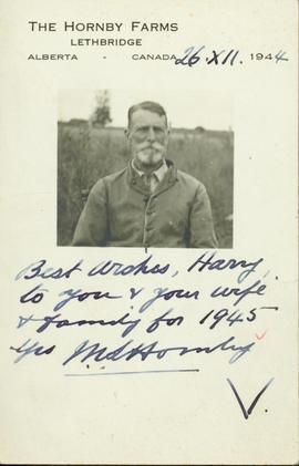
Card consists of a photograph of (presumably) M.S. Hornby and reads: "The Hornby Farms, Lethbridge, Alberta, Canada, 1944: Best wishes Harry to you & your wife & family for 1945. Yrs M.S. Hornby".
Handwritten annotation on recto: "McBride Bridge 1924-25"
Photograph is adhered to cardboard matting and has a hand drawn "frame" decorating it's perimeter. Handwritten annotation on the recto of the matte, directly under the photograph, lists the names of the photo subjects.
Haystacks in a field.
Map of BC/ Yukon, AB. On other side, is a map of Downtown PG.
? Includes mileage chart, example from Prince George to Vancouver is 518 miles.
? Prince George map is in black and white. BC/Yukon map is black and white, but the water is coloured blue.
- Invitation for the Old Timers Reunion to meet up with “old friends [such] as Alex Moffat, Billy Fraser, Fred Burden and L.C. Gunn.”
- Invitation signed by the Premier of BC: W.A.C Bennett.
Handwritten annotation on recto: "Peace River banks".
Handwritten annotation on recto: "Stuck on Blackwater Road 1923"
Auction Sale Plan showing Prince George Lots 936, 937, 938 and 1429, Prince George Lot 343. Group 1 Cariboo District.
Handwritten annotation on recto: "Trip to Peace River - riding with [MLA] Ian Mackenzie, Hon. W. Sutherland". Photo depicts a row boat being poled against the dock while six men, including H. Perry wait to disembark.
Handwritten annotation on verso: "11 Sep 1935, The monument is 18 feet high, they say. Some 16th century Chinese coins were found when the foundations were being dug. I heard of this the day before I left Victoria, and it seems worth enquiring into. Yours Sincerely, R (?) Bishop"; "I received medal for Bishop in 1935 in London from the Royal Geographical Society".
B.C.-Yukon-Alaska Highway Commission – Map showing Highway Routes to Accompany Preliminary Report on Proposed Highway to Alaska
? January 1940
? Legend includes: 1) Existing Main Highways, 2) Roads in Northern Area, 3) Routes Under Construction.
Dirt roads crossing a large, cleared section of land. Some buildings seen along the left edge of the image.