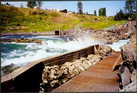
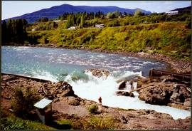
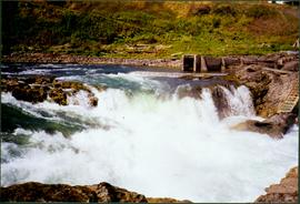
Photograph depicts white rapids at bottom of waterfall in Bulkley River, B.C. Fishing territory visible on far right; hill on opposite shore in background.
Photograph depicts water in foreground, bayside village in background.
Photograph depicts unknown lake. Grassy shore in foreground, mountains in background.
Photograph depicts lake in surrounding field. Grave marker on rock in right foreground. Handwritten annotation on recto of photograph: "This is a picture of the lake (part of it) the rock is in the bottom right corner on a knoll. You can see the plaque on it. But it isn't very clear."
Woman stands in front of sign that reads "ALASKA / STEWART 237 km / HYDER AK. 240 km / BEAR GLAC. 201 km". Second sign in background indicates restaurant, convenience store, and service centre. Car, road, and highway can be seen in midground; mountains in background. (This woman is also featured in item 2008.3.1.22.13).
Photograph depicts fishing territory at waterfall rapids in Bulkley River, B.C. Highway and buildings on opposite shore in background.
Photograph depicts an unidentified individual standing on cliff above waterfall at Bulkley River, B.C. Fishing territory visible below; highway, buildings, and hills visible in background.
Photograph depicts sign in foreground outlining rules and restrictions for behaviour at Moricetown Canyon. Traditional fishing territory visible behind sign at waterfall in the Bulkley River, B.C. Highway and buildings can be seen in background.
Photograph depicts wide river with forest shores on either side. Power lines in foreground, mountain in background.
Photograph depicts what appears to be a lava bed, see item 2008.3.1.22.33.
Photograph depicts two white buildings, one with the sign "Nisga'a Government Administration building". Road in foreground, vehicles and hills in background.
Photograph depicts Moran seated to right of woman on bench in foreground. Waterfall area at Moricetown Canyon can be seen below, behind booth labeled "MONITER BOOTH". Highway and houses visible on opposite shore in background.
Photograph depicts Bridget Moran standing beside unidentified man in front of white building with the sign "Nisga'a Government Administration building". Suburban parked in front of building, trees and mountains visible in background.
Photograph depicts colour map displayed in unknown area, second poster semi-visible on left. See item 2008.3.1.22.34 for image believed to depict lava bed.
Photograph depicts dog seated on grass in foreground. Unidentified individuals visible below with fishing nets in waterfall area at Moricetown Canyon.
Photograph depicts landscape scene. Tree, bridge, and sign featuring cross country skier in foreground. Fence, hills, and forest in background.
Water and opposite shore visible in background. Handwritten annotation on verso: "Miracle Beach - March 31/80".
Photograph depicts two large buildings across street in foreground, van visible on left.
Photograph depicts three women standing on beach in their Women's Royal Canadian Naval Service uniform. Waves and rocks in background. Handwritten annotation on recto of photograph: "Do you believe this?" Left to right: Bridget Moran, Betty Pincombe (aka 'Chick'), and Grace Boice (aka Tommy).
Photograph depicts three women sitting on beach in their Women's Royal Canadian Naval Service uniform. Purses and shoes lay beside them, large rock stands in background. Handwritten annotation on recto of photograph: "The California 'Beauties' 1946." Left to right: Betty Pincombe (aka 'Chick'), Bridget Moran, and Grace Boice (aka Tommy).
Photograph depicts unknown lake. Moran slightly visible in far left. Village can be seen on opposite shore in background.
Profile of Moran, wake visible in water behind her. Opposite shore in background.
Bridget Moran stands on road, unidentified buildings behind on either side. Lake and hills on opposite shore in background. Photo believed to be taken at Metlakatla Lake, B.C. Building on left speculated to be the St. Paul's Anglican Church Learning Centre.
Photograph depicts Moran standing in front of bridge featuring a sign reading "USE OF BRIDGE AT YOUR OWN RISK / GITWINKSIHLKW BAND COUNCIL". River below, hills on opposite shore in background.
Photograph depicts small boats tied at dock on lake with mountains visible in background.