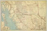
Showing 2 results

Archival description
1 results with digital objects Show results with digital objects
Central British Columbia
2008.2.1.21 · Item · 1 May 1940
Part of Northern BC Cartographic Collection

Topographic map depicts communities, bodies of water, transport routes, parks, game reserves, posts, ports, radio stations, power sites (figures in horse power), steamship routes (distance in nautical miles), and precipitation. Mineral resources summarized locally in red ink.