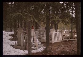
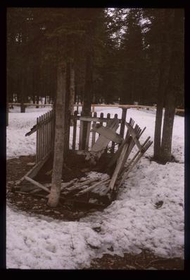
Image depicts an old, rotting grave marker in the Stanley Cemetery.
Image depicts the Stanley Cemetery.
Image depicts Bobtail Lake.
Image depicts Pineview on Buckhorn Lake Road, Prince George, B.C.
File contains slides depicting a caving group in various places in West Virgina, USA.
File contains slides depicting the Peyto Glacier.
File contains slides depicting the Ram Glacier.
Image depicts a marker for aerial photography at an uncertain location. The slide labels it as "Elizabeth Station."
Image depicts a road located somewhere near Birken, B.C.
Image depicts the Place Glacier.
Image depicts an unknown individual at the Place Glacier.
Image depicts the mostly frozen Place Creek Falls.
Image depicts two unknown individuals at the Place Glacier.
Image depicts some power lines and a forest somewhere near Birken, B.C.
Image depicts the Place Glacier. There are two unknown individuals present.
Image depicts two unknown individuals at the Woolsey Glacier.
Image depicts a snow-covered cabin and a mountain in the distance. It is located somewhere near Birken, B.C.
Image depicts a mountain in the distance. It is located somewhere near Birken, B.C.
Image depicts a road located somewhere near Birken, B.C.
Image depicts the Place Glacier.
Image depicts the Place Glacier. There are two unknown individuals present.
Image depicts two unknown individuals at the Woolsey Glacier.
Image depicts a helicopter flying over the Woolsey Glacier.
Image depicts an unidentified individual setting up some sort of pole in the snow for a process the slide labels as "snow sounding." The location is uncertain.
Image depicts an unidentified individual standing next to a marker and a stake at an uncertain location.
Image depicts objects, including a flag pole, that the slide labels as "survey equipment." The slide also places it as a "Peyto icefall," on the Peyto Galcier in the Banff National Park in Alberta, B.C.
File consists of a pamphlet titled "The Fort Fraser-Fort George Bulletin Area" prepared by the Department of Lands, Forests, and Water Resources from the Province of British Columbia.
File contains slides depicting the Woolsey and Place Glaciers.
Image depicts a scenic view of a mountain and forest at an uncertain location.
Image depicts a hand-held ice drill.
Image depicts an unidentified individual drilling into the ice.
Image depicts the cableway in Willow River, B.C.
Image depicts the Fraser River from Northwood Road in the Prince George area.
Image depicts the Stellako River.
Image depicts the rubble of a demolished house at Island Cache, with several other buildings in the background.
Image depicts a junk pile of bottles, cans and bags, as well as the gutted frame of an old car, at Island Cache.
Image depicts an area of cut trees at Island Cache.
Image depicts numerous houses, and an unknown child standing in a street at Island Cache.
Image depicts a street in Island Cache.
Image depicts a few houses in Island Cache.
Image depicts a street in Island Cache.
Image depicts Wells, B.C.
Image depicts a sunshine recorder at an uncertain location.
Image depicts two unidentified individuals and a van on a farm at an uncertain location, possibly a place called Cypress Hill, with an atmometer and a sunshine recorder.
Image depicts the shore line and surrounding land of a lake or river at an airport, possibly in Prince George, B.C.
Image depicts a bulldozer and truck in an unknown location.