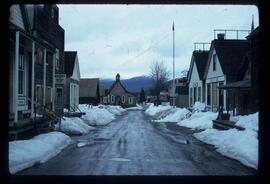
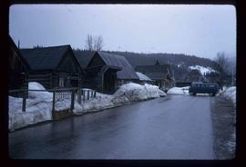
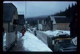
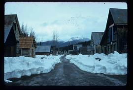
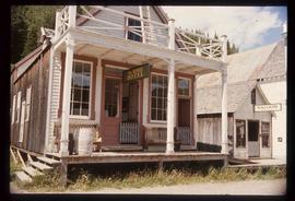
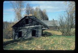
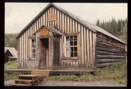
Image depicts a Sporting House in Barkerville.
Image depicts a street in Barkerville, B.C.
Image depicts the House Hotel in Barkerville, B.C.
Image depicts the Barkerville theatre from the porch of the Hudson's Bay Company.
Image depicts the Wake Up Jake Saloon in Barkerville, as well as several other buildings.
Image depicts the interior of the Wake Up Jake Saloon in Barkerville, B.C.
Image depicts a souvenir and gift shop for both Barkerville and Wells, B.C.
Image depicts an old barn somewhere in the Fort George Canyon Provincial Park, B.C.
Image depicts an old barn and a collapsing cabin somewhere in the Fort George Canyon Provincial Park, B.C.
The item is a photograph depicting an old, unused, wooden barn on Holzworth homestead in the Fort George Canyon.
The item is a photograph depicting an old, abandoned wooden barn on the Holzworth homestead in the Fort George Canyon.
The item is a photograph depicting a large white barn at Salmon Valley Ranch. The structure is wooden with a sheet metal roof. There are two cars parked outside the barn and a child standing next to the barn.
The item is a photograph depicting a large white barn at Salmon Valley Ranch. The structure is wooden with a sheet metal roof. There is a child standing next to a car parked outside the barn.
File consists of notes and reproductions relating to the Prince George Secondary School (formerly Baron Byng High School and Prince George High School).
Image depicts a section of river located somewhere near Barriere, B.C.
The photograph depicts Barry McKinnon standing next to a stack of railroad ties near Finmoore, B.C. in the summer. Annotation on reverse side of photograph states, "Finmoore 2010, Barry McKinnon."
The photograph depicts Barry McKinnon standing on train tracks near Finmoore, B.C. in the summer.
Image depicts a basalt landform somewhere in or near Quesnel, B.C.
Item is an original map depicting the Bateman forestry route. Map includes pen markings.
Image depicts the Battle Hill National Historic Site in Kitwanga, B.C.. The sign located there says: "The small knoll in the valley was a native fortress. Legends maintain that it was man-made: built to repel marauding coastal tribes. The hill was the scene of local tribal battles, and at one time was crowned with the defenders' buildings. Known as Dhawdezp, the unique mound is a prominent feature in the legends and history of the Indian people."
Image depicts a Bavarian style house at College Heights in Prince George, B.C.
Subseries contains material collected and created by Kent Sedgwick for research on various areas in British Columbia and Alberta. Includes written notes by Kent Sedgwick, pamphlets, and newspaper clippings relating to towns and settlements. These areas include Quesnel, Likely, the Yukon Telegraph Trail, Barkerville, Wells, the Cariboo region, Fort Alexandria, Soda Creek, the Chilcotin region, Jasper, the Rocky Mountains, Mackenzie, Tumbler Ridge, the Peace River region, Fort St. James, the Omineca region, Kitimat, Lethbridge, the Bulkley Valley, and Fort Mcleod. These files cover a variety of topics including Chinese people in British Columbia, land settlement, tourism, and historic information on the regions.
File contains slides depicting maps from the B.C. Atlas.
File consists of notes and reproductions relating to the Upper Fraser historical geography field trip for the BC Historical Federation by Kent Sedgwick. Includes photographs depicting a group from the BC Historical Federation standing outside at one of the East Line communities listening to a presentation by Kent Sedgwick and Greg Halseth (May 2003).
Image depicts the BC Liquor Store in Prince George, B.C.
File contains slides depicting views of numerous B.C. Mountains.
The item is a reproduction of an aerial photograph of Prince George. Annotation states, "City of Pr. Geo. 1958 Aereal Photo CBD."
The item is a reproduction of an aerial photograph of Prince George between 1972 to 1975.
Image depicts the BCR tracks passing through a mill somewhere near the 100 Mile.
The item is a photograph depicting a dog on the beach along the Fraser River in Fort George Canyon.
Image depicts a bear located at the Bear Lake Dump.
Image depicts a small section of the Bear Glacier.
Image depicts a close-up of a cave-like opening in the Bear Glacier.
Image depicts the Bear Glacier in Bear Glacier Provincial Park, as well as what is possibly Strohn Lake.
Image depicts the Bear Glacier in Bear Glacier Provincial Park.
Image depicts a close-up of the Bear Glacier in Bear Glacier Provincial Park.
Image depicts Bear Glacier in the foreground and a mountain in the background, somewhere in Bear Glacier Provincial Park.
Image depicts the Bear Glacier with a cave-like opening.
Image depicts Bear Glacier in the foreground and numerous mountain peaks in the background in Bear Glacier Provincial Park.
Image depicts Sue and Kent Sedgwick with two dogs, standing with the Bear Glacier in the background.
Image depicts Sue Sedgwick with a dog, standing with the Bear Glacier in the background.
Image depicts the Bear Glacier stretching through a mountain range.
Image depicts a dog on a road, and a view of the mountains in Bear Glacier Provincial Park.
Image depicts a stand of trees in Bear Lake, B.C.