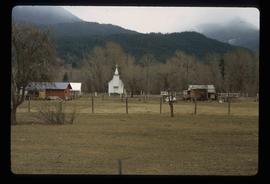
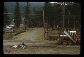
The item is a photograph depicting an old, out of use barn, two silos, and two stables at Salmon Valley Ranch.
File consists of notes and reproductions relating to the Salmon Valley Ranch. Also includes photographs depicting the Salmon Valley Ranch.
Item is an original 1954 map depicting Salmon Valley British Columbia, published by British Columbia Department of Lands and Forests. Map includes pen markings.
Image depicts the Salvation Army on Ospika Boulevard in Prince George, B.C. Map coordinates 53°55'02.6"N 122°47'41.6"W.
Image depicts the Salvation Army on Ospika Boulevard in Prince George, B.C. Map coordinates 53°55'02.6"N 122°47'41.6"W
Image depicts sand beds with a shovel present for size reference. The slide places it at the "BCR site," possibly in Prince George, B.C.
File contains slides depicting places in Saskatchewan.
The item is a photograph of Saver's Optical on 3rd Avenue in Prince George.
Image depicts a sawmill, possibly Lakeland Sawmill, in Prince George B.C.
Image depicts logs being stripped of their bark at a saw mill in Prince George, B.C.
Image depicts the interior of a saw mill somewhere in Prince George, B.C.
Image depicts logs being cut into planks in the interior of a saw mill somewhere in Prince George, B.C.
Image depicts wood planks in the interior of a saw mill somewhere in Prince George, B.C.
Image depicts a saw mill, possibly Lakeland Mills, with a beehive burner and numerous piles of logs in the foreground, in Prince George, B.C.
Image depicts numerous stripped logs and several unidentified individuals in hard hats at a saw mill somewhere in Prince George, B.C.
Image depicts a saw cutting a log in half at a saw mill in Prince George, B.C.
Image depicts numerous blocks of wood planks at a saw mill, possibly Lakeland Mills, somewhere in Prince George, B.C.
Image depicts machinery in a saw mill somewhere in Prince George, B.C.
Image depicts machinery stripping a log of its bark in a saw mill somewhere in Prince George, B.C.
Image depicts numerous buildings at an uncertain location. A beehive burner and what appears to be a large pile of wood is visible in the background.
Item is an original 1987 map depicting Saxton Lake in British Columbia, published by the Department of Energy, Mines and Resources Ottawa, Canada. The map includes pen markings.
Image depicts a scenic view of a section of land at an unknown location.
Image depicts a scenic view of a mountain and forest at an uncertain location.
Image depicts a relatively flat section of land with hills in the distance; the location is uncertain.
Image depicts a view of a forested area and a frozen river at an unknown location.
Image depicts a school and playground, possibly in New Aiyansh, B.C.
File consists of forms created by Kent Sedgwick for recording research regarding schools.
File contains slides depicting schools in Prince George, B.C.
The item is a photograph depicting the exterior view of the front of Scotiabank at 1210 3rd Avenue, Prince George. Part of Royal Dry Cleaners at 1222 3rd Avenue can be seen. Photograph originally taken between 1978 and 1979.
The item is a photograph of the former S. E. Kresge Co. building on 3rd Avenue in Prince George.
The item is a photograph of the former S. E. Kresge Co. building on 3rd Avenue in Prince George. Scotiabank building is visible in the background.
File contains slides depicting Sechelt, B.C.
File consists of notes, clippings, and reproductions relating to secondary sources of Prince George's development and historiography. Includes: "Ted Williams Slides" notes by Kent Sedgwick; "Nechako River cutbanks" card with a painting depicting the Nechako River cutbanks in Prince George; "Historic Timeline of Prince George" typed document created by Kent Sedgwick (2009); "Historiography of Northern British Columbia Project" typed document sent out to College Height Secondary School by Ted Renquist regarding a project to develop a historiography of Northern British Columbia (15 Apr. 1991); and "Canadian Encyclopedia" typed letter from Adriana Bryenton with the Canadian Encyclopedia requesting review of the Prince George article for the Canadian Encyclopedia (29 June 1994).
File consists of reproductions and photocopies of articles on the history of city planning in North America. File predominantly consists of printed articles: "Encyclopedia of Urban Planning" by Arnold Whittick; "Radburn and the American Planning Movement: The Persistence of an Idea" by Eugenie Ladner Birch; "The Making of Urban America: A History of City Planning in the United States" by John W. Reps; and "The Story of the Planner's Journal 1915-1980" by Donald A. Krueckberg.
Image depicts a large group of people examining the sediment layers in a rock face.
Image depicts an unidentified individual standing in front of a rock face with visible sediment layers. Located somewhere in the Peace River Region, possibly near Hudson's Hope.
Image depicts a wall of rock with visible sediment layers at an uncertain location in the Peace River Region, possibly near Hudson's Hope.
File consists of photographs separated from other boxes and subseries depicting downtown Prince George, historic Prince George, the North Thompson region, Fort St. James historic site, Brooks, Alberta, Sinclair Mills, and Soda Creek.
Image depicts a view of Seton Portage in the trees, located between the two lakes, Seton and Anderson.
Image depicts a view of Seton Lake, located near Lillooet, B.C.
Image depicts what is either Seton or Anderson Lake near Seton Portage, B.C.
Image depicts a lake near Seton Portage; it is likely either Anderson or Seton Lake.
Image depicts a small shack on the shore of a lake near Seton Portage; it is likely either Anderson or Seton Lake.
Image depicts a frozen water fall located at a lake near Seton Portage; it is likely either Anderson or Seton Lake.
Image depicts the side of a train and the tracks it is on, as well as a small section of what is either Seton or Anderson Lake near Seton Portage, B.C.
Image depicts a river somewhere in Seton Portage, B.C.
Image depicts a church and several houses in Seton Portage, B.C.
Image depicts numerous houses and a tractor in Seton Portage, B.C.
Image depicts a type of gate system for the river water, possibly controlling irrigation, located somewhere in Seton Portage, B.C.