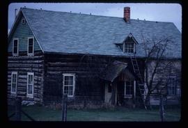
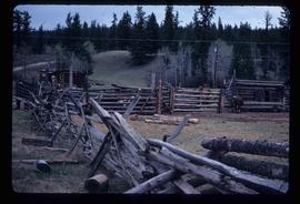
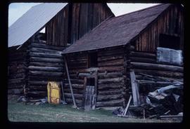
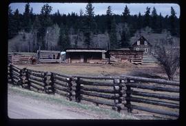
Image depicts what appears to be a junkyard for old mining equipment at an uncertain location, though possibly near Gibraltar.
Image depicts a group of people at a mine somewhere near Hazelton, B.C.
Newspaper is a special edition of Prince George Citizen entitled "Millenium Timeline." The edition is about the new millennium and entering the twenty-first century.
The item is the millennium edition of The Prince George Free Press. The "Millenium Report" was one of two different inserts in an unknown December 1999 issue. The edition contains information about Prince George's past and speculation as to where Prince George will be in the future.
File consists of notes, clippings, and reproductions relating to the planning of Millennium Park at First Avenue and George Street in Prince George. Includes: "Cairn at Millennium Park" typed document by Kent Sedgwick (Mar. 2000) and correspondence letters between Kent Sedgwick, The City of Prince George, and Environment Canada (1987).
File consists of newspaper clippings relating to the millennium in Prince George. Includes the article "'Looking forwards from our past': A Citizen millennium project" from the Prince George Citizen (29 Dec. 1999). Also includes "Millenium Timeline" special edition of Prince George Citizen (29 Dec. 1999); and special editions from the Prince George Free Press: "Millennium Report" (Dec. 1999) and "Millennium Report: Where we've been... Where we're going". (Dec. 1999). Also includes a millennium postage keepsake tin with three souvenir sheets (1999).
File consists of notes, clippings, and reproductions relating to the Millar Addition subdivision in Prince George.
File consists of notes, clippings, and reproductions relating to the Millar Addition in Prince George. Includes: "Heritage Walking Tour" pamphlet from Revelstoke Museum (2001); "A Millar Addition Heritage Tour" pamphlet from the Fraser Fort George Regional Museum (1985); and "RE: 1461 and 1423 Ingledew residences" typescript letter from Denise McCallum, Curator at the Fraser Fort George Museum Society to the Roman Catholic Episcopal of Prince Rupert (26 Feb. 1985). Also includes photographs depicting houses within the Millar Addition, including houses at the addresses 1389 Ingledew Street, 1711 Elm Street, and a house on Gorse Street (2008).
File consists of notes and reproductions relating to the Millar Addition High School.
File consists of notes and reproductions relating to a heritage interpretative sign for the Millar Addition in Prince George. Includes: "RE: Millar Addition Sign" letter from the Borealis Creative Productions to Kent Sedgwick (28 June 1995). File also includes photographs depicting Fort George Park, a street view, and houses in the Millar Addition of Prince George (1995).
File consists of notes relating to the Millar Addition Elementary School.
Image depicts a view of the Millar Addition suburb in Prince George, B.C.
File contains slides depicting the Millar Addition suburb in Prince George, B.C.
Image depicts numerous trees on the bank of a river, possibly in Miles Canyon near Whitehorse, Y.T. The slide is labelled "canyon city."
Image depicts numerous unidentified individuals getting off a boat which bears the name "Schwatka." It is located somewhere in Miles Canyon.
Image depicts the Robert Lowe Bridge, built in 1922, in the Miles Canyon near Whitehorse Y.T.
Image depicts several unidentified individuals on a boat in the Miles Canyon near Whitehorse Y.T.
Image depicts a river in the Miles Canyon near Whitehorse Y.T.
Image depicts a river in the Miles Canyon near Whitehorse Y.T. The Robert Lowe Bridge, built in 1922, can be seen over the canyon.
Image depicts the river which runs through Miles Canyon, located near Whitehorse Y.T.
Image depicts a river at an uncertain location, but possibly in Miles Canyon near Whitehorse, Y.T.
Image depicts a stretch of land from Highway 97 at Mile 231, possibly near Clinton, B.C.
Image depicts the property of an old ranch at Mile 108 of Highway 97.
Image depicts Middle River by Trembleur Lake.
Image depicts the Meziadin Lake and the Bear Pass in the distance.
Image depicts the Meziadin Lake.
Image depicts the fish ladder of the Meziadin Falls, designed to help fish swim upstream.
Image depicts the Meziadin Falls in Meziadin Lake Provincial Park.
Image depicts several salmon somewhere in the Meziadin Lake Provincial Park.
Image depicts several individuals looking down into a closed off section of a river in Meziadin Lake Provincial Park. They are counting fish.
Image depicts buildings in the village community of Metlakatla, B.C.
Image depicts Metlakatla, located near Prince Rupert, B.C.
Image depicts buildings in the village community of Metlakatla, B.C.
The photograph depicts a metal engraving that is likely on a metal door at the roundhouse in the CN Railyard in Prince George, B.C. Engraving reads "GTPRY 296." Reproduction of photograph from 1984.
The item is a photograph of Merle Norman Cosmetics and an unknown commercial building on 3rd Avenue in Prince George.
Image depicts a house with torn-up siding. The slide is labelled: "Mellos house relocated from Penny." The location is uncertain.
Image depicts a yellow building in Meldrum Creek.
Image depicts a ranch house in Meldrum Creek, B.C.
Image depicts fenced-in cattle on a farm or ranch in Meldrum Creek, B.C.
Image depicts an old, collapsing shack in Meldrum Creek, B.C.
Image depicts a barnyard of cattle and chicken on a farm or ranch in Meldrum Creek, B.C.
Image depicts part of the McMillan Creek Trail in the McMillan Regional Park in Prince George, B.C.
Image depicts part of the McMillan Regional Park in Prince George, B.C.
Image depicts the McMillan Creek from Northwood Pulpmill Road, in Prince George, B.C.
Image depicts the McLeod River in Carp Lake Provincial Park.
Item is an original 1969 map depicting McLeod Lake in British Columbia, published by the Department of Energy, Mines and Resources in Ottawa.