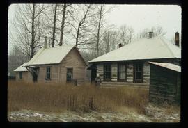
The item is a photograph depicting the front and side of the log Hixon schoolhouse. Annotation on reverse side of photograph states, "Canyon Cr. (Hixon)."
The item is a photograph depicting the front rear side of the log Hixon schoolhouse. A weathered white building is situated next to the old school. A lens flare obscures the center of the photograph. Annotation on reverse side of photograph states, "APS Hixon School."
The item is a photograph depicting the rear side of the log Hixon schoolhouse. Annotation on the reverse side of the photograph states, "APS."
Image depicts the Hixon School and teacherage buildings in Hixon, B.C.
Image depicts the Hixon School Teacherage.
Image depicts several unidentified individuals standing in front of a store selling honey.
Image depicts an unidentified man holding what appears to be a broken screen of honeycombs. The group is likely at an educational event.
Photograph depicts the Hong Kong Inn and restaurant at 1210 3rd Avenue. Annotation on verso: "Dredaute Bldg c. 1948".
Image depicts the town of Horsefly, B.C.
Image depicts several horses near a camper somewhere in Quesnelle Forks, B.C.
Image depicts what is possibly Hospital Beach in Kitimat, B.C. The facility in the background is possibly the Alcan smelter.
Image depicts the hospital building and another building in Wells, B.C.
File consists of notes, clippings, and reproductions relating to hotels and motels in Prince George, including material on the former Prince George Hotel, which was on the corner of Fifth Avenue and George Street; the Alexandra Hotel which was built in Central Fort George at the corner of Third Avenue and Brunswick Street; The Europe Hotel on Third Avenue; The National Hotel at 1201 First Avenue; the London Hotel at 1479 Third Avenue; Astoria Hotel at 233 George Street; The Canada Hotel at 206 George Street; The Columbus Hotel which was at 1250 Third Avenue; and the Northern Hotel in South Fort George. File primarily includes various clipped articles from the Prince George Citizen newspaper and printed photographs from The Exploration Place Museum database and The Royal BC Museum and Archives.
Image depicts a house in 127 Mile House, B.C.
Image depicts a house with the main floor and entrance high off the ground. The location is uncertain, likely Giscome, B.C.
Image depicts a house, most likely on Thompson Drive in Prince George, B.C.
Image depicts a house with a vehicle in a garage and the number 40 on it; location is uncertain.
Image depicts a blue house for sale on Upper Fraser Rd. Location is likely Upper Fraser, B.C.
The item is a photograph slide reproduction depicting a blue house surrounded by flood waters in Prince George.
Image depicts a house in Giscome, B.C. Map coordinates 54°04'17.6"N 122°22'06.1"W
Image depicts a small house with brightly coloured door and window frames in Penny, B.C.
The item is a photograph of three houses in the industrial area off of Queensway in Prince George.
The item is a photograph of a house in the industrial area off of Queensway in Prince George.
The item is a photograph of a house in the industrial area off of Queensway in Prince George. Annotation on back of photograph sates, "2 doors east."
The item is a photograph depicting the back of a four-level stucco house in South Fort George. Various appliances are being kept by the house. The house is likely located in the Hazelton Street area, Prince George.
Image depicts and old house and vehicle in Upper Fraser, B.C. Map coordinates 54°07'05.7"N 121°56'38.9"W
Image depicts the interior of an old house, possibly the Cottonwood House, and most likely in or near Barkerville, B.C.
The item is a photograph depicting an old, weathered house near Penny church. The house is in disrepair with a damaged roof and boarded up windows. Annotation on reverse side of photograph states, "Penny church house?"
The item is a photograph depicting a house on 12th Avenue before demolition to make room for the Parkwood commercial area. Annotation on back of picture states, "demolished July / 91 for Parkwood expansion. 1734(?) 12th ave."
The item is a photograph depicting a house on 12th Avenue before demolition to make room for the Parkwood commercial area. Annotation on back of picture states, "removed July / 91 2 blue spruce + 12th ave."
The item is a photograph depicting the exterior of old damaged house on the Moffat farmland. There is a broken fence at the rear of the house, broken windows and a collapsed roof.
The item is a photograph depicting the front of a white house on Queensway in Prince George. The house is located in the 1400 or 2400 block of Queensway. There is a beige car and green truck parked in front of the house. Annotation on reverse side of the photograph states, "Houses on w. side of Queensway SFG 1970s? #2."
Image depicts a house on the shore somewhere on Haida Gwaii.
Image depicts a house being removed from Upper Fraser, B.C. during demolition of town site. A sign on the house reads: "Murray Blackwell House Raising & Moving." Map coordinates 54°06'51.6"N 121°56'26.3"W
Image depicts a house with some Firts Nations' art painted on the front, somewhere on Haida Gwaii, B.C.
Image depicts a house with ivy growing over it. The location is uncertain.
Image depicts a set of train tracks, a farmhouse, and some fields; possibly in Woodpecker, B.C.
The item is a photograph depicting the exterior view of the front of Household Finance HFC at 1272 3rd Avenue, Prince George. There is a brown station wagon parked in front of the building. Photograph originally taken between 1978 and 1979.
Image depicts numerous houses, and an unknown child standing in a street at Island Cache.
Image depicts a few houses in Island Cache.
Image depicts a number of houses at an uncertain location, possibly Williams Lake, B.C.
Image depicts many houses somewhere in Wells, B.C.
Image depicts a row of houses somewhere in Wells, B.C.
Image depicts a row of houses in Tumbler Ridge, B.C.
Image depicts a row of houses in Wells, B.C.
Image depicts a row of houses somewhere in Wells, B.C.