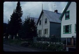
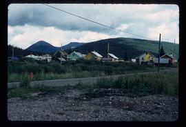
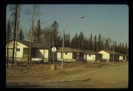
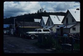
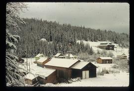
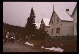
Showing 3026 results

Archival description
Houses
2012.13.1.22.12 · Item · 1970
Part of J. Kent Sedgwick fonds

Image depicts numerous houses, and an unknown child standing in a street at Island Cache.

Houses
2012.13.1.22.30 · Item · 1970
Part of J. Kent Sedgwick fonds

Image depicts a few houses in Island Cache. There are two unknown individuals present.

Houses
2012.13.1.22.17 · Item · 1970
Part of J. Kent Sedgwick fonds

Image depicts a few houses and a dog on a porch at Island Cache.

Houses and a Ballpark
2012.13.1.93.01 · Item · 1978
Part of J. Kent Sedgwick fonds

Image depicts a view of numerous houses and a ballpark at an uncertain location. It is possibly located somewhere in the Peace River Region.

Houses and a Church
2012.13.1.37.19 · Item · 1978
Part of J. Kent Sedgwick fonds

Image depicts a row of houses, as well as a United Church of Canada on the right side of the image, located in Wells, B.C.

Houses and Three Goats
2012.13.1.87.021 · Item · [between 1975 and 1995]
Part of J. Kent Sedgwick fonds

Image depicts several houses, and three goats standing on a narrow dirt road. The location is uncertain, likely Sinclair Mills, B.C.

Houses and Train in Giscome
2012.13.1.87.073 · Item · [between 1975 and 1995]
Part of J. Kent Sedgwick fonds

Image depicts the Giscome B.C. townsite from across the railroad tracks looking southeast. Map coordinates 54°04'19.7"N 122°22'04.7"W

Houses in Giscome
2012.13.1.87.072 · Item · [between 1975 and 1995]
Part of J. Kent Sedgwick fonds

Image depicts the Giscome B.C. townsite from across the railroad tracks looking southeast. Map coordinates 54°04'19.7"N 122°22'04.7"W

Houses on Dogwood Street
2012.13.1.24.34 · Item · 2000
Part of J. Kent Sedgwick fonds

Image depicts houses on Dogwood Street in the Millar Addition neighbourhood of Prince George, B.C. On the left is 1610 Dogwood Street and 1630 Dogwood Street is the middle house; 1650 Dogwood Street is the blue house on the right.

Houses on Stilts
2012.13.1.6.106 · Item · Nov. 1980
Part of J. Kent Sedgwick fonds

Image depicts a number of houses built on stilts over a body of water in an uncertain location.

Hydraulic
2012.13.1.69.30 · Item · [1981?]
Part of J. Kent Sedgwick fonds

Image depicts the old log buildings of the town of Hydraulic, B.C.

Ice Rafted Boulders
2012.13.1.125.22 · Item · [1982?]
Part of J. Kent Sedgwick fonds

Image depicts a boulder protruding from layers of sediment with a hammer beside it for size reference. It is located somewhere in Soda Creek, B.C.

In Memory Of - Grave-Marker
2012.13.1.87.150 · Item · [between 1975 and 1995]
Part of J. Kent Sedgwick fonds

Image depicts a grave-marker with several names, it reads: "In Memory of Edith Golder, Winnifred Golder, Baby Pelton, Mrs. Nazarek, Baby Nazarek, Baby Wazylyk 1915 - 1929." It is located in the Willow River Cemetery.

2012.13.4.30 · File · 1986-2006
Part of J. Kent Sedgwick fonds

File consists of notes, clippings, and reproductions relating to the Cariboo and Northwest Digest publication. Also includes a CD-R that contains Sedgwick's index spreadsheet and accompanying documentation about the publication.

Industrial Machinery
2012.13.1.4.14 · Item · July 1980
Part of J. Kent Sedgwick fonds

Image depicts a piece of industrial machinery, likely for either mining or forestry, in an uncertain location near McLeod Lake, B.C.

Inlander Hotel
2012.13.1.51.060 · Item · May 1973
Part of J. Kent Sedgwick fonds

Image depicts the Inlander Hotel in Hazelton, B.C. The peak of the Rocher de Boule mountain is visible in the background.

Inside Machinery
2012.13.1.93.50 · Item · 1978
Part of J. Kent Sedgwick fonds

Image depicts two individuals at work inside what appears to be a piece of machinery. It is possibly located somewhere in Fort St. John, B.C.