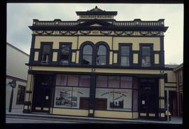
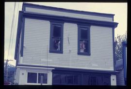
Image depicts a pair of mannequins in the second story windows of a building, possibly located in Skagway, Alaska.
Image depicts the old railroad building in Skagway, Alaska.
Image depicts the bus depot in Skagway, Alaska (USA).
Image depicts Skeena Crossing, B.C.
Image depicts two totem poles in Skeena Crossing, B.C.
Image depicts two unidentified individuals examining a tractor meant to delimb trees. It is located in Prince George, B.C.
Image depicts the community of Skidegate on Haida Gwaii.
Image depicts a skier in a costume with a fake sword, somewhere on the Birchleg Ski route on Tabor Mountain in Prince George, B.C.
Image depicts an aerial view of what appears to be a small farm, possibly in the McGregor Canyon.
Image depicts a small, abandoned house in Woodpecker, B.C.
Image depicts a view of what appears to be a small town at an uncertain location.
Image depicts the CN rail station in Smithers B.C.
Image depicts a snow gauge at an uncertain location.
Image depicts the restored White Pass Snow Plow No.1 in Skagway, Alaska.
Image depicts a snow-covered road at an uncertain location.
Image depicts the Buckhorn Snowmobile Club, though it was formerly the Buckhorn school.
Image depicts the annex for the Buckhorn Snowmobile club.
Image depicts a snow-covered road with vehicle tracks, and several houses. The location is uncertain.
Image depicts a bridge at Soda Creek, B.C. There are numerous unknown individuals present.
Image depicts the old BX Sternwheeler office building in Soda Creek, B.C.
Image depicts the cemetery in Soda Creek, B.C.
Image depicts a house in Soda Creek, B.C.
Image depicts the old community hall in Soda Creek, B.C.
Image depicts the old jail house in Soda Creek, B.C.
Image depicts an old building located somewhere are the Pickard farm north of Soda Creek, B.C.
Image depicts what appears to be a Ranch at Soda Creek, B.C.
Image depicts a section of land, with a few houses, in Soda Creek, B.C.
Image depicts a house somewhere in the South Fort George subdivision of Prince George, B.C.
Image depicts Southbank, B.C.
Image depicts the interior of the ferry at Southbank, B.C.
Image depicts a few houses, most likely near the airport in Prince George, B.C.
Image depicts a rural setting, most likely near the airport in Prince George, B.C.
Image depicts an old building at an uncertain location. The slide is simply labelled "Spring house."
Image depicts a Lakewood view of Spruceland in Prince George, B.C.
Image depicts the St. Joseph's Roman Catholic Church, in Kamloops, B.C.
Image depicts a large crowd of people seated inside the St. Joseph's Roman Catholic Church in Kamloops, B.C.
Image depicts the altar inside the St. Joseph's Roman Catholic Church in Kamloops, B.C.
Image depicts a representation of the crucified Christ in the St. Joseph's Roman Catholic Church in Kamloops, B.C.
Image depicts St. Mark's Anglican Church in Woodpecker, B.C.
Image depicts the St. Mark's Anglican Church and a small house in Woodpecker, B.C.
Image depicts the St. Mark's Anglican Church and a small house in Woodpecker, B.C. There is an unknown individual present.
Image depicts the St. Mark's Anglican Church and a small house in Woodpecker, B.C.
Image depicts the St. Marks Community Church in Stewart, B.C.
Image depicts the interior of the St. Marks Community Church in Stewart, B.C.
Image depicts St. Peter's Church in Mackenzie, B.C.