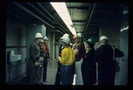
Image depicts a group of unidentified individuals wearing hard hats inside an unknown concrete structure, possibly located in Fort St. John, B.C.
Image depicts numerous pieces of what appears to be old farming equipment. There is also an unidentified individual sitting aginst the side of a building. The location is possibly Fort St. John, B.C.
Image depicts an unidentified man in a greenhouse, possibly somewhere in Fort St. John, B.C.
Image depicts several unidentified individuals inside of a church made from logs, possibly located in Fort St. John, B.C.
Image depicts several unidentified individuals exiting a church made of logs, possibly in Fort St. John, B.C.
Image depicts a group of unidentified individuals in a greenhouse, possibly somewhere in Fort St. John, B.C.
Image depicts two unidentified individuals in hard hats leaning against the railing of a large, open space inside an unknown concrete structure. It is possibly located in Fort St. John, B.C.
Image depicts a view of Fort St. John, B.C.
Image depicts the old Trading Outpost in Fort St. James, B.C.
Image depicts the interior of the historic Hudson's Bay Company Trading Post, with several unknown individuals present, in Fort St. James, B.C.
Image depicts the interior of the historic Hudson's Bay Company Trading Post in Fort St. James, B.C.
Image depicts the interior of the historic Hudson's Bay Company Trading Post, with several unknown individuals present, in Fort St. James, B.C.
Image depicts a partially frozen lake, most likely Stuart Lake in Fort St. James, B.C.
Image depicts an old shack on stilts in Fort St. James, B.C.
Image depicts the Hudson's Bay Company Trading Post at the historic site in Fort St. James, B.C.
Image depicts the interior of the historic Hudson's Bay Company office in Fort St. James, B.C.
Image depicts the historic Hudson's Bay Company office in Fort St. James, B.C.
Image depicts the Hudson's Bay Company historic site in Fort St. James, B.C.
Image depicts the interior of a historic building in Fort St. James, B.C.
Image depicts a historic building in Fort St. James, B.C.
Image depicts an old log building in Fort St. James; the sign on it reads "Clerk's Living Quarters, Later Used as Fort St. James First School."
Image depicts a church in Fort St. James, B.C.
Image depicts the Fort George Regional Museum in Prince George, B.C.
Image depicts the Fort George Regional Museum (now known as The Exploration Place) in Prince George, B.C. Map coordinates 53°54'18.6"N 122°44'09.8"W
Image depicts the Fort George Regional Museum in Prince George, B.C. Map coordinates 53°54'18.6"N 122°44'09.8"W
Image depicts the Fort George Park. Map coordinates 53°54'30.2"N 122°43'57.4"W
Image depicts a building from the 1880's in Fort Fraser.
Image depicts the abandoned and crumbling Forman's General Store somewhere in or near either Barkerville or Wells, B.C.
Image depicts several pieces of heavy machinery used in forestry. The Coast Inn of the North is seen in the background.
Image depicts an unidentified individual examining a piece of heavy machinery used in the forestry industry. It is located in Prince George, B.C.
Image depicts a forestry cabin located in Tête Jaune Cache, B.C.
Image depicts the Foothills Bridge over the Nechako river on the Foothills Boulevard in Prince George, B.C. Map coordinates 53°56'52.5"N 122°48'59.9"W
Image depicts a narrow footbridge suspended over a river at an uncertain location.
Image depicts what appears to be a footbridge at an uncertain location.
Image depicts the Flying U Ranch at 70 Mile House, B.C.
Image depicts numerous boats docked by a buildings identified as the "Prince Rupert Fishermen's Co-operative Association."
Image depicts several unidentified individuals standing outside a building, and holding intricately painted drums; the woman on the right is Sue Sedgwick. The location is uncertain.
Image depicts several unidentified individuals standing outside a building and holding intricately painted drums; Kent Sedgwick is standing the middle of the group with Sue Sedgwick beside him. The location is uncertain.
Image depicts several unidentified individuals standing outside a building, and holding intricately painted drums. The location is uncertain.
Image depicts several unidentified individuals standing outside a building, and holding intricately painted drums; the woman on the right is Sue Sedgwick. The location is uncertain.
Image depicts a snow sculpted fire place and couch on a skating rink, possibly during the Winter City Conference, in Prince George, B.C. Taken at the Prince George Civic Center. Map coordinates 53°54'45.6"N 122°44'59.6"W
Image depicts the old Fire Hall, now a museum, in Stewart, B.C.