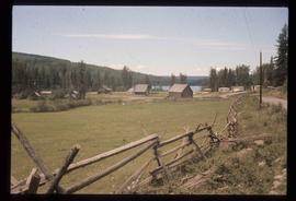
Image depicts a set of train tracks, a farmhouse, and some fields; possibly in Woodpecker, B.C.
Image depicts numerous houses, and an unknown child standing in a street at Island Cache.
Image depicts a few houses in Island Cache.
Image depicts a few houses and a dog on a porch at Island Cache.
Image depicts a view of numerous houses and a ballpark at an uncertain location. It is possibly located somewhere in the Peace River Region.
Image depicts several houses, and three goats standing on a narrow dirt road. The location is uncertain, likely Sinclair Mills, B.C.
Image depicts the Giscome B.C. townsite from across the railroad tracks looking southeast. Map coordinates 54°04'19.7"N 122°22'04.7"W
Image depicts a row of houses in Upper Fraser, B.C. Map coordinates 54°06'51.6"N 121°56'26.3"W
Image depicts a number of houses built on stilts over a body of water in an uncertain location.
Image depicts Howe Sound.
Image depicts the Britannia Mine, which closed in 1974 and is now a museum. "Anaconda" was the last operating owner.
Image depicts a view of Howe Sound from the Stawamus Chief Nature Trail to the Stawamus Chief Mountain, which is often incorrectly referred to as "Squamish" Chief.
Image depicts a cabin and several other buildings, possibly located in Hudson's Hope, B.C.
Image depicts a road and numerous buildings in Hudson's Hope, B.C.
Image depicts a street in Hudson's Hope, B.C.
Image depicts what appears to be a Fire Hall in Hudson's Hope, B.C.
Image depicts an old, three-storey building beside a two-storey hotel in Hudson's Hope, B.C.
Image depicts two houses in Hudson's Hope, B.C.
Image depicts a street with a building which is labelled "MacKeigan Enterprises Ltd." in Hudson's Hope, B.C.
Image depicts what appears to be a motel in Hudson's Hope, B.C. The slide is labelled "camp HH."
Image depicts the log building that acts as the public library in Hudson's Hope, B.C.
Image depicts the W.A.C. Bennett Dam in Hudson's Hope, B.C.
Image depicts the Raven Lake Hut on the other side of Raven Lake.
Image depicts a small grey building, possibly Raven Cabin, sitting at the foot of a ridge.
Image depicts the old log buildings of the town of Hydraulic, B.C.
Image depicts a hand-held ice drill.
Image depicts an unidentified individual drilling into the ice.
Image depicts a boulder protruding from layers of sediment with a hammer beside it for size reference. It is located somewhere in Soda Creek, B.C.
Image depicts a grave-marker with several names, it reads: "In Memory of Edith Golder, Winnifred Golder, Baby Pelton, Mrs. Nazarek, Baby Nazarek, Baby Wazylyk 1915 - 1929." It is located in the Willow River Cemetery.
Image depicts Indianpoint Lake.
Image depicts the Inlander Hotel in Hazelton, B.C. The peak of the Rocher de Boule mountain is visible in the background.
Image depicts what is possibly an intrusive volcanic landform somewhere near Miworth, B.C.
Image depicts Iron Road North, and a creek surrounded by trees. Located north of Woodpecker, B.C.
Image depicts Iron Road South, which is located north of Woodpecker, B.C.
Image depicts the street sign for Iron Road South, which is located north of Woodpecker, B.C.
Image depicts what is possibly an irrigation channel somewhere in Seton Portage, B.C.
Image depicts the Isaac Falls.
Image depicts a log jamb at the Isaac Falls.
Image depicts Isaac Lake.
Image depicts Isaac Lake from the Betty Wendle campsite.
Image depicts a camp at the Betty Wendle campsite at Isaac Lake.
Image depicts the sunset over Isaac Lake from the Betty Wendle campsite.
Image depicts the ferry at Isle Pierre, B.C.
Image depicts the ferry in Isle Pierre, B.C.
Image depicts the dock for ferries in Isle Pierre, B.C.