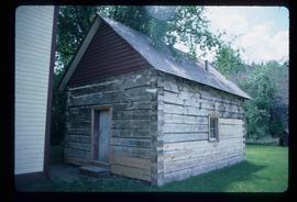
Showing 1595 results

Archival description
1595 results with digital objects Show results with digital objects
Giscome Station
2012.13.1.6.034 · Item · May 1975
Part of J. Kent Sedgwick fonds

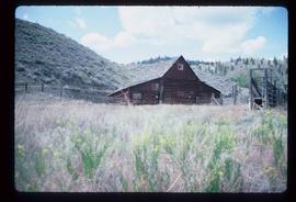
Image depicts the old Giscome Train Station in Giscome, B.C. It was demolished between 1976 and 1977.

Giscome Street Scene
2012.13.1.87.173 · Item · [between 1975 and 1995]
Part of J. Kent Sedgwick fonds

Image depicts a street in Giscome B.C. The Giscome Store is located on the left side of the image with the church in the background. Map coordinates 54°04'18.5"N 122°21'57.7"W

Grain Elevator and Dock
2012.13.1.77.35 · Item · 1980
Part of J. Kent Sedgwick fonds

Image depicts a large vessel docked at a grain elevator and two smaller boats at a dock in the foreground somewhere in Prince Rupert, B.C.

Granduc Townsite
2012.13.1.83.04 · Item · 1979
Part of J. Kent Sedgwick fonds

Image depicts a row of houses in Granduc, near the Granduc Mine and located north of Stewart, B.C.

Hallway
2012.13.1.37.07 · Item · 1974
Part of J. Kent Sedgwick fonds

Image depicts a hallway in an unknown building somewhere in Wells, B.C.

Handshake
2012.13.1.133.09 · Item · 1985
Part of J. Kent Sedgwick fonds

Image depicts a man and woman shaking hands in a building at an uncertain location, possibly in Cottonwood Park. The man standing behind the two is possibly Elmer Mercier, a former mayor of Prince George, B.C.

Hansard Rail Bridge
2012.13.1.89.184 · Item · 2004
Part of J. Kent Sedgwick fonds

Image depicts the Hansard railroad bridge taken from the new Hansard vehicle bridge. Map coordinates 54°04'58.1"N 121°50'58.0"W

2012.13.1.58.05 · Item · June 1987
Part of J. Kent Sedgwick fonds

Image depicts the McLean Cabin, built in 1861, which belonged to a retired Hudson's Bay Chief trader named Donald McLean, who was shot and killed while part of a posse that was searching for the murderers of a survey party. It is located at the historic Hat Creek Ranch site north of Ashcroft, B.C.