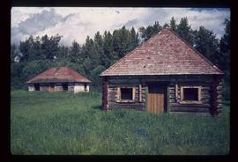
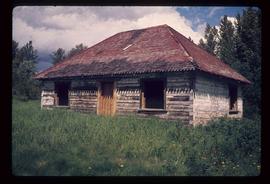
Image depicts an old house somewhere in McBride, B.C.
Image depicts a view of what is either the Rocky Mountains or possibly the Columbia Mountains from McBride, B.C.
Image depicts a view of what is either the Rocky Mountains or possibly the Columbia Mountains in the background of a small section of McBride, B.C.
Image depicts a street in McBride, B.C.
Image depicts the CN Station in McBride, B.C.
Image depicts the rear-end of the CN Station in McBride, B.C.
Image depicts the McBride CNR station.
Image depicts the McBride District Centennial Library.
Image depicts the McBride Hotel near the Mt. Robson Provincial Park.
Image depicts a view of the Herrick River in what is possibly McGregor Canyon; the slide is simply labelled "McG above Canyon."
Image depicts a view of the Herrick River in what is possibly McGregor Canyon; the slide is simply labelled "McG Canyon."
Image depicts a view of the Herrick River in what is possibly McGregor Canyon; the slide is simply labelled "McG above Canyon."
Image depicts a view of the Herrick River in what is possibly McGregor Canyon; the slide is simply labelled "McG Canyon - above Herrick."
Image depicts the McGregor River at an uncertain location.
Image depicts what is possibly the McGregor River.
Image depicts the McGregor River at an uncertain location.
Image depicts a bridge over the McGregor River. A sign in the image reads: "Danger. The river is not navigable for any type of boat. Down stream falls and rapids impassible!"
Image depicts a bridge over the McGregor River.
Image depicts the McGregor from the point of view of a bridge.
Image depicts a view of McGregor Valley from an uncertain location.
Image depicts a view of McGregor Valley.
Image depicts a view of the McGregor Valley.
Image depicts a view of McGregor Valley.
Image depicts a view of McGregor Valley from an uncertain location.
Image depicts a view of McGregor Valley.
Image depicts numerous burned tree stumps somewhere in the McGregor Valley.
Image depicts a red vehicle parked on the side of the road with a view of the McGregor Valley behind it. The slide is labelled "dam site."
Image depicts numerous felled trees somewhere in the McGregor Valley.
Image depicts a gravel road somewhere in the McGregor Valley.
Image depicts a what is possibly the McGregor River in the McGregor Valley.
Image depicts a pass in the McGregor Valley.
Image depicts a view of a section of a pass in the McGregor Valley.
Image depicts a dirt road and a densely forested treeline, possibly in the McGregor Valley.
Image depicts a building by the shore of McLeod Lake.
Image depicts McLeod Lake, with the view facing north-west.
Image depicts McLeod lake.
Image depicts McLeod Lake.
Image depicts McLeod Lake and several buildings along the shore.
Image depicts the old Hudson's Bay Company Trading Post at McLeod Lake.
Image depicts a shack with a red roof near McLeod Lake.
Image depicts the McLeod River in Carp Lake Provincial Park.
Image depicts the McMillan Creek from Northwood Pulpmill Road, in Prince George, B.C.