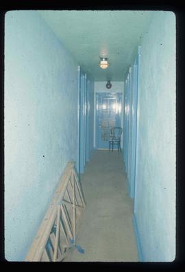
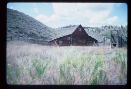
Image depicts an example of "typical housing" in Granduc, near the Granduc Mine and located north of Stewart, B.C.
Image depicts Grassy Plains, B.C.
Image depicts the grave of W.L. Meason in the upper Fraser Canyon.
Image depicts numerous grave markers at an uncertain location.
Image depicts a small graveyard at an uncertain location.
File contains slides depicting Greenwood, B.C.
Image depicts a large group of people in a room at an uncertain location in the Peace River Region.
The photograph depicts seven men and women on the railway turntable at the CN Railyard in Prince George, B.C. Reproduction of photograph from 1984.
Image depicts a group of individuals standing on the corner of 3rd Ave in Prince George, B.C.
Image depicts the Grand Trunk Pacific railway roundhouse in Prince George, B.C.
File contains slides depicting images of the Grand Trunk Pacific railway roundhouse in Prince George, B.C.
Image depicts the Grand Trunk Pacific railway roundhouse in Prince George, B.C.
Image depicts the GTP roundhouse in Prince George, B.C.
Image depicts the Grand Trunk Pacific railway roundhouse in Prince George, B.C.
Image depicts the interior of the GTP roundhouse in Prince George, B.C.
Image depicts machinery in the GTP roundhouse in Prince George, B.C.
The photograph depicts the Grand Trunk Pacific Railyard roundhouse and water tower in Prince George, B. C. Reverse side of photograph states, "Photo Credit: Fort George Museum." Reproduction from [192-?].
The item is a photograph of Gundy's News and an empty commercial building on 3rd Avenue in Prince George.
The item is a photograph depicting the exterior view of the front of Gundy's News Supply Ltd. at 1244 3rd Avenue, Prince George. Part of the Columbus Hotel and Pub at 1250 3rd Avenue and a vacant building at 1232 3rd Avenue can be seen. There is a woman standing outside one of the businesses. Photograph originally taken between 1978 and 1979.
The item is a photograph of the H&R Block building and an empty commercial building on 3rd Avenue in Prince George.
Image depicts a bridge in Hagwilget, B.C.
Image depicts a church on a hill in Hagwilget, B.C.
File contains slides depicting places on Haida Gwaii, formerly known as the Queen Charlotte Islands.
Image depicts an old, half-collapsed building at an uncertain location.
Image depicts a house on Blackwater Road.
Image depicts a hallway in an unknown building somewhere in Wells, B.C.
The photograph depicts a hallway with windows at the interior of the CN roundhouse in Prince George, BC. Reproduction of photograph from 1984.
Image depicts a man and woman shaking hands in a building at an uncertain location, possibly in Cottonwood Park. The man standing behind the two is possibly Elmer Mercier, a former mayor of Prince George, B.C.
Image depicts the new Hansard Bridge. Map coordinates 54°04'57.9"N 121°51'10.1"W
Image depicts the Hansard railroad bridge taken from the new Hansard vehicle bridge. Map coordinates 54°04'58.1"N 121°50'58.0"W
Image depicts the Hansard railroad bridge looking west. Map coordinates 54°04'37.9"N 121°50'46.3"W
File consists of clippings, notes, and reproductions relating to the house of Harry G. Perry, a politician and founding community member of Prince George. Includes: "Heritage site inventory" typescript document (1988); "Heritage advisory committee minutes" reproduction of a typescript document (13 Nov. 1980); "Application to rezone lots" typescript document from the City of Prince George (3 Mar. 1982); "By-law No. 3631" typescript document from the City of Prince George (24 Nov. 1980); "Minutes" typescript document from the Prince George and Fraser-Fort George Regional District Heritage Advisory Committee (13 Nov. 1980); "The Carter House" typescript letter from the Heritage Advisory Committee to the City of Prince George (21 Sept. 1979); and "RE: Status Report" typescript document from the City of Prince George to the Joint Heritage Committee (9 Sept. 1980). Also includes architectural drawings depicting plans for building the Carter house at 1850 Tenth Ave, Prince George (1979).
Image depicts Glenview Drive near the Hart Highway in Prince George, B.C.
Image depicts a neighbourhood on the Hart Highway in Prince George, B.C.
Image depicts a "box barn" on the historic Hat Creek Ranch site north of Ashcroft, B.C.
Image depicts the McLean Cabin, built in 1861, which belonged to a retired Hudson's Bay Chief trader named Donald McLean, who was shot and killed while part of a posse that was searching for the murderers of a survey party. It is located at the historic Hat Creek Ranch site north of Ashcroft, B.C.
Image depicts an old barn on the historic Hat Creek Ranch site north of Ashcroft, B.C.
Image depicts numerous individuals standing near the Ranch house and McLean Cabin on the historic Hat Creek Ranch site north of Ashcroft, B.C.
Image depicts several individuals sitting on the front porch of the Ranch house on the historic Hat Creek Ranch site north of Ashcroft, B.C.
Image depicts the Ranch house on the historic Hat Creek Ranch site north of Ashcroft, B.C.
Image depicts the front of the ranch house on the historic Hat Creek Ranch site north of Ashcroft, B.C.