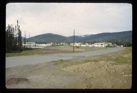
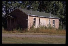
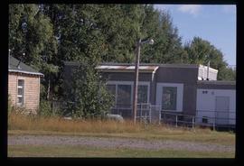
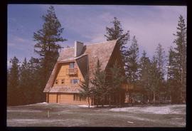
Image depicts Riske Creek, B.C. The brown building on the left is the local school.
Image depicts the Esso gas station in Riske Creek, B.C.
The item is a photograph depicting Rhein Gold at 1177 3rd Avenue, Lot 17, Prince George. Wooden building with "For Rent" sign in one window.
File contains slides depicting Revelstoke.
Image depicts the interior of a church in Shelley, B.C.
Image depicts the interior of the church after its restoration, in Shelley, B.C.
Photograph depicts residential buildings along 4th Avenue east of Winnipeg Street. Annotation on verso: "series on s. side of, 4th east from Winnipeg, (railway houses)".
Photograph depicts residential buildings at 1662 and 1674 9th Avenue, one with a green roof and one with a metal roof. Annotation on verso: "1674 - 9th Ave green roof), 1662 - 9th Ave (metal roof)."
Photograph depicts a residential building in the North Thompson region.
Photograph depicts a residential building in the North Thompson region. The house is blue and surrounded by trees.
Photograph depicts a residential building at the corner of 6th Avenue and Winnipeg Street. Annotation on verso: "NE corner, 6th / Winnipeg".
Photograph depicts a residential building on the corner of Vancouver Street and 10th Avenue. Annotation on verso: "Trick house, Vancouver/ 10th".
Photograph depicts a residential building at 825 Vancouver Street. Annotation on verso: "Van Horlick c-7".
Photograph depicts a residential building at 1798 5th Avenue. Annotation on verso: "1798 - 5th Ave".
Photograph depicts a residential building at 1795 10th Avenue. Annotation on verso: "1795 - 10th Ave, SE corner of, Winnipeg".
Photograph depicts a residential building at 1770 5th Avenue. Annotation on verso: "1770 - 5th Ave".
Photograph depicts a residential building at 1722 7th Avenue. Annotation on verso: "1722 - 8th Ave".
Photograph depicts a residential building at 1661 10th Avenue. Annotation on verso: "1661 - 10th Ave".
Photograph depicts a residential building at 1651 5th Avenue. Annotation on verso: "1651 - 5th Ave".
Photograph depicts a residential building at 1648 8th Avenue. Annotation on verso: "1648 - 8th, next to Rosel's".
Photograph depicts a residential building at 1643 10th Avenue. Annotation on verso: "1643 - 10th Ave".
Photograph depicts a residential building at 1625 4th Avenue. Annotation on verso: "Loedel proposal, 1625 - 4th, (see above)".
Photograph depicts a residential building at 1617 8th Avenue. Annotation on verso: "1617 - 8th Ave".
Photograph depicts a residential building at 1616 8th Avenue, on the corner of Vancouver Street. Annotation on verso: "1616 -8th Ave, NW corner of Vancouver".
Photograph depicts a residential building at 1612 12th Avenue, the building was used as "Prince Realty". Annotation on verso: "1612 - 12th Ave., NW corner of Vancouver."
Photograph depicts a residential building at 1601 6th Avenue, the corner of 6th Avenue and Vancouver Street. Annotation on verso: "CUTE c-7, union, Vancouver/ 6th".
Image depicts a residential area with a playground somewhere in Mackenzie, B.C.
Photograph depicts a Rental and repair shop on 3rd Avenue.
Image depicts a building in Reid Lake
File consists of a CD, an audiocassette, and a typed transcript of an interview with Trelle Morrow conducted by Kent Sedgwick. Trelle Morrow was an architect in Prince George between 1950 and 2000 and during the interview in 2007 he was a retired member of the Architectural Institute of B.C. The interview includes discussions on the buildings Trelle Morrow contributed to in Prince George and his life surrounding his work.
File contains slides depicting places in or around Red Rock, Hixon, and Woodpecker, B.C.
File contains slides depicting images of places in or around Red Rock, Hixon, and Woodpecker, B.C.
Image depicts a the teacherage building in Red Rock.
Image depicts the Red Rock School.
Image depicts a building in Red Rock.
File contains slides depicting numerous recreational locations from various places in Canada.
Image depicts a woman standing on the porch of a hut located by Raven Lake.
Photograph depicts the graves of Seward Rankin, Gerald Rankin, and James Rankin at the Soda Creek Cemetery.
Image depicts the ranch house of the Ranch of the Vikings, originally owned and operated by Bjorger Pettersen, a member of the Canadian Ski Hall of Fame, from 1970 until 1985. It is located somewhere west of McBride, B.C.
Image depicts a wooden Ranch House at an uncertain location.
Image depicts the Ramada Hotel in Prince George, B.C.
Photograph depicts an octagonal railway water tower at an unknown location.
The photograph depicts roundhouse turntable at the CN Railyard in Prince George, B.C. A CN train engine and multiple buildings can be seen in the background. Reproduction of photograph from 1984.
Image depicts railway tracks on the right side of the image, and several old houses alongside it. The location is uncertain.
Image depicts a set of railway tracks and a long building located somewhere in the Peace River Region.
The photograph depicts the exterior side of the roundhouse in the CN Railyard in Prince George, B.C. Silhouette of two people in a doorway and railway equipment in the yard are portrayed. Reproduction of photograph from 1984.