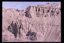
Image depicts an esker at the Foothills Boulevard in Prince George, B.C.
Image depicts a narrow footbridge suspended over a river at an uncertain location.
Image depicts what appears to be a footbridge at an uncertain location.
Image depicts a camp at the foot of Isaac Lake.
Image depicts the foot of Indianpoint Lake.
Image depicts the Flying U Ranch at 70 Mile House, B.C.
Image depicts a flooded area with an old sawdust pile in the background. Likely near McGregor, B.C.
Image depicts numerous tree logs floating on a body of water. The location is uncertain, but is likely Eaglet Lake.
Image depicts some power lines and a forest somewhere near Birken, B.C.
Image depicts five unknown individuals somewhere near Mt. Robson.
Image depicts two individuals fishing in a canoe on McCleary Lake. The slide is also labelled "dolly," likely meaning the fish in the net is a Dolly Varden trout.
Image depicts two youths fishing from the bank of the Nechako River on Cottonwood Island.
Image depicts a few unidentified individuals fishing in a river at an uncertain location.
Image depicts numerous boats docked by a buildings identified as the "Prince Rupert Fishermen's Co-operative Association."
Image depicts a faded First Nations' rock painting.
Image depicts an unknown woman pointing towards some faded First Nations' rock paintings.
Image depicts the old Fire Hall, now a museum, in Stewart, B.C.
Image depicts numerous skiers standing near a finish line somewhere on Tabor Mountain in Prince George, B.C.
Image depicts the Fraser River, likely near the Hansard railroad bridge.
Image depicts a ferry entering Horseshoe Bay in the Howe Sound region.
Image depicts two unidentified individuals standing outside a small, enclosed area somewhere in a forest. The location is uncertain.
Image depicts a fence and power lines near the shore on Haida Gwaii. It is possibly a small community such as Masset.
Image depicts a fence, perhaps somewhere in the Chilcotin region.
Image depicts a fence in the Blackwater River area in the Chilcotin.
Image depicts a fence somewhere in Anahim Lake, B.C.
Image depicts a large number of felled trees, and an unknown individual standing on the path.
Image depicts an unknown individual standing next to what appears to be a fault at an unknown location.
Image depicts what appears to be a fault at an unknown location.
Image depicts a farm at an uncertain location.
Image depicts a farm on the west side of the Fraser, south of Quesnel, B.C.
Image depicts what appears to be a farm at an uncertain location.
Image depicts a farm at an uncertain location.
Image depicts a farm at an uncertain location; possibly somewhere in the McGregor Valley.
Image depicts a farm at an unknown location.
Image depicts some fallen trees at Island Cache.
Image depicts a view of an experimental farm, possibly taken from Tabor Mountain.
Image depicts three unidentified individuals examining rocks near a set of railway tracks at an uncertain location in the Peace River Region.
Image depicts a group of individuals who appear to be examining a rock. It is possibly part of an educational trip.
Image depicts an atmometer. According to the slide, it is being used for measuring the rate of water evaporation "from carborundum stone." The location is uncertain.
Image depicts Eskers Park, near Prince George, B.C.
Image depicts an eroding rock face; the river in the right corner of the image is possibly the Fraser River.
Image depicts what appears to be an eroding rock face. The slide itself is labelled "ash loger at top" for unknown reasons. Possibly located somewhere near Whitehorse, Y.T.
Image depicts an eroding rock face at an uncertain location.
Image depicts a building surrounded by a tall, circular enclosure somewhere on Haida Gwaii, B.C.
Image depicts employee houses on mill site in Giscome, B.C. Tug boats are in the foreground on the right. Map coordinates 54°04'23.4"N 122°22'16.9"W
Image depicts an earth flow north of Stone Creek, B.C.