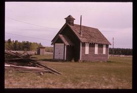
Image depicts the old jail house in Soda Creek, B.C.
Image depicts an old building located somewhere are the Pickard farm north of Soda Creek, B.C.
Image depicts a section of land, with a few houses, in Soda Creek, B.C.
Image depicts the cutbanks of the Fraser River at Soda Creek, B.C.
Image depicts a cemetery in the South Fort George suburb of Prince George, B.C.
Image depicts an aerial view of a chain of lakes in South Tweedsmuir Provincial Park.
Image depicts an aerial view of South Tweedsmuir Provincial Park.
Image depicts a view of South Tweedsmuir Provincial Park.
Image depicts an aerial view of South Tweedsmuir Provincial Park.
Image depicts a lake and mountain somewhere in South Tweedsmuir Provincial Park.
Image depicts an aerial view of a lake in South Tweedsmuir Provincial Park.
Image depicts an aerial view of South Tweedsmuir Provincial Park.
Image depicts a view of South Tweedsmuir Provincial Park. An unidentified man stands on the side of the image.
Image depicts an aerial view of a "glaciated valley" in South Tweedsmuir Provincial Park. Glacier Mountain is present in the image.
Image depicts an aerial view of Glacier Mountain in South Tweedsmuir Provincial Park.
Image depicts an aerial view of what is likely Glacier Mountain in South Tweedsmuir Provincial Park. The two lakes present are possibly Vista and Junker.
Image depicts an aerial view of South Tweedsmuir Provincial Park. The lake is possibly Lonesome Lake.
Image depicts an aerial view of a lake in South Tweedsmuir Provincial Park. It is possibly Lonesome Lake.
Image depicts an aerial view of what is likely Turner Lake in South Tweedsmuir Provincial Park.
Image depicts Southbank, B.C.
Image depicts Spectacle Lake.
Image depicts the river channel leading to the Spectacle Lakes.
Image depicts a mountain in the distance, and the river channel leading to the Spectacle Lakes.
Image depicts mountains, taken from the river channel leading to the Spectacle Lakes.
Image depicts a man, most likely Kent Sedgwick, using what appears to be some type of a spigot on a tree.
Image depicts a spiky rock formation at an uncertain location.
Image depicts a fishing boat on the water somewhere near Prince Rupert, B.C. Only half of its name is visible: "spirit."
Image depicts an old building at an uncertain location. The slide is simply labelled "Spring house."
Image depicts an unidentified individual standing next to a marker and a stake at an uncertain location.
Image depicts an old, rotting grave marker in the Stanley Cemetery.
Image depicts the Stanley Cemetery.
Image depicts a large vessel docked in Prince Rupert, B.C. The name on its side is "Star Capella." The slide itself is labelled "superport."
Image depicts a long line of people cross country skiing along the Birchleg route on Tabor Mountain in Prince George, B.C.
Image depicts the start of Joffre Creek Road, most likely somewhere in the Joffre Lakes Provincial Park.
Image depicts the start of the Raven trail, with the view angled towards Raven Peak in the distance.
Image depicts a woman standing next to a steam shovel, located in Quesnelle Forks.
Image depicts a steam shovel, located in Quesnelle Forks.
Image depicts a steep mountain road somewhere in the area of Seton Portage, B.C.
Image depicts the Stellako River.