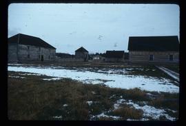
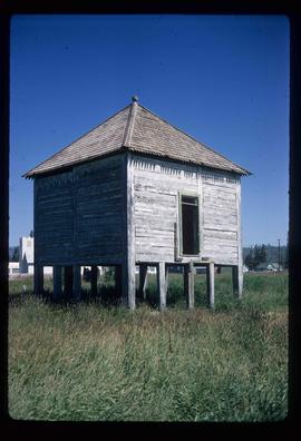
Image depicts an old shack on stilts in Fort St. James, B.C.
Image depicts the Hudson's Bay Company Trading Post at the historic site in Fort St. James, B.C.
Image depicts the interior of the historic Hudson's Bay Company office in Fort St. James, B.C.
Image depicts the historic Hudson's Bay Company office in Fort St. James, B.C.
Image depicts the Hudson's Bay Company historic site in Fort St. James, B.C.
Image depicts the interior of a historic building in Fort St. James, B.C.
Image depicts a historic building in Fort St. James, B.C.
Image depicts an old log building in Fort St. James; the sign on it reads "Clerk's Living Quarters, Later Used as Fort St. James First School."
Image depicts a church in Fort St. James, B.C.
File consists of notes, clippings, and reproductions relating to Fort St. James, the community and historic site. Includes material regarding the development of the community as a trading post for Hudson's Bay Company and the development of the historic site. Includes: "Fort St. James National Historic Site" pamphlet prepared by Parks Canada (1981); "Fort St. James National Historic Park" pamphlet prepared by Parks Canada (1974 and 1978); and photographs entitled "UNBC Student trip" and depict a snowy landscape and wooden cabin (Mar. 2004).
Image depicts the Fort George Regional Museum in Prince George, B.C.
Image depicts the Fort George Regional Museum (now known as The Exploration Place) in Prince George, B.C. Map coordinates 53°54'18.6"N 122°44'09.8"W
Image depicts the Fort George Regional Museum in Prince George, B.C. Map coordinates 53°54'18.6"N 122°44'09.8"W
The item is a photograph looking at Fort George Park, now known as Lheidli T'enneh Memorial Park, from 17th Avenue, Prince George.
Image depicts the Fort George Park. Map coordinates 53°54'30.2"N 122°43'57.4"W
Image depicts the Fort George Par, which was renamed Lheidli T'enneh Memorial Park in 2015. Map coordinates 53°54'30.2"N 122°43'57.4"W
Image depicts an aerial view of Fort George Park.
The item is a photograph depicting Fort George Canyon and the Fraser River. Sticker on reverse side of photograph states, "Charlotte Air Box 2276 Prince George B.C. Canada V2N 2J8 Copyright."
The item is a photograph depicting the Fraser River running through Fort George Canyon.
The item is a photograph depicting the Fraser River running through Fort George Canyon. Annotation on revers side of the photograph states, "6."
The item is a photograph depicting the Fraser River running through the Fort George Canyon.
The item is a photograph depicting the Fraser River running through Fort George Canyon.
The item is a photograph depicting the Fraser River running through Fort George Canyon. Annotation on revers side of the photograph states, "6."
The item is a photograph depicting the Fraser River running through Fort George Canyon.
The item is a photograph depicting the Fraser River running through the Fort George Canyon.
The item is a photograph depicting the Fraser River running through Fort George Canyon.
File consists of notes, clippings, and reproductions relating to the Fort George Canyon. Includes: "City of Prince George" typescript letter from Kent Sedgwick to Mr. Ron Drane, Manager of Pine Centre (7 June 1984) and "Fort George Canyon Hiking Trail" pamphlet published by the Fraser-Fort George Regional Museum (July 1984). Also includes photographs depicting the Fort George Canyon and men hiking the trail (1985).
The item is a photograph depicting Fort George Canyon looking west down the Fraser River. Annotation on reverse side of photograph states, "looking west 1."
The item is a photograph depicting Fort George Canyon looking north up the Fraser River. Annotation on reverse side of photograph states, "looking north upstream 2."
The item is a photograph depicting the Fraser River running through Fort George Canyon.
The item is a photograph depicting the Fraser River running through the Fort George Canyon.