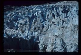
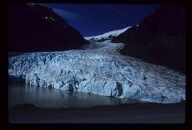
Image depicts the Bear Glacier in Bear Glacier Provincial Park.
Image depicts a close-up of the Bear Glacier in Bear Glacier Provincial Park.
Image depicts Bear Glacier in the foreground and a mountain in the background, somewhere in Bear Glacier Provincial Park.
Image depicts the Bear Glacier with a cave-like opening.
Image depicts Bear Glacier in the foreground and numerous mountain peaks in the background in Bear Glacier Provincial Park.
Image depicts Sue and Kent Sedgwick with two dogs, standing with the Bear Glacier in the background.
Image depicts Sue Sedgwick with a dog, standing with the Bear Glacier in the background.
Image depicts the Bear Glacier stretching through a mountain range.
Image depicts a dog on a road, and a view of the mountains in Bear Glacier Provincial Park.
Image depicts a stand of trees in Bear Lake, B.C.
Image depicts some houses in Bear Lake, B.C.
Image depicts some trailers in Bear Lake, B.C.
Image depicts some houses in Bear Lake, B.C.
Image depicts some houses most likely in Bear Lake, B.C.
Image depicts some buildings along a dirt road, possibly near Bear Lake, B.C.
Image depicts a river, possibly near Bear Lake, B.C.
Image depicts a shack, possibly near Bear Lake, B.C.
Image depicts the Crooked River in the Crooked River Pronvicial Park near Bear Lake, B.C.
Image depicts the curling club and skating rink buildings in Bear Lake, B.C.
Image depicts some houses in Bear Lake, B.C.
Image depicts a view of Bear Pass, likely from Glacier Highway and somewhere in or near Bear Glacier Provincial Park, located north-east of Stewart, B.C.
Image depicts what is possibly Bear River in the Bear Glacier Provincial Park.
Image depicts the Bear River.
Image depicts what is possibly Bear River in the Bear Glacier Provincial Park.
Image depicts what is possibly Bear River, flowing out from an opening in the Bear Glacier.
Image depicts what is possibly Bear River flowing past what is likely a section of the Bear Glacier.
Image depicts a section of road running through the Bear River Gorge.
Image depicts a snow sculpture of a bear, possibly during the Winter City Conference, in Prince George, B.C. Taken at the Prince George Civic Center. Map coordinates 53°54'45.6"N 122°44'59.6"W
The item is a photograph depicting the derelict Bearman barn in Newlands.
The item is a photograph depicting the derelict Bearman barn in Newlands. Annotation on reverse side of photograph states, "Bearman Barn, Newlands."
Image depicts the canoe group preparing to canoe on Beaver Pond, which is the start of Kibbee Lake.
Image depicts a field of hay somewhere in Beaver Valley.
File consists of notes, reproductions, and typescript documents relating to Beaverly Elementary School. Includes: "Beaverly School" typescript letter from Kent Sedgwick to the Beaverly Community Association (30 Oct. 1987). Also includes photographs depicting the old weathered wooden Beaverly School building (Nov. 2001).
Image depicts a log cabin in Beaverly.
Image depicts what appears to be a small ranch. The slide is labelled "Becher's Prairie," possibly meaning Becher's Prairie Provincial Park in B.C.
Image depicts an esker at Bednesti Lake, B.C.
Image depicts a man in a yellow cap who appears to be blowing smoke into a bee colony at a bee farm. It appears to be an educational demonstration.
Image depicts a bee-hive burner beside a rail-road track at an unidentified mill somewhere in Prince George, B.C.
Image depicts a beehive burner, as well as rail road tracks, at an unknown location.
Image depicts a Beehive Burner along the Nechako on River Road. Map coordinates 53°55'34.1"N 122°44'58.0"W