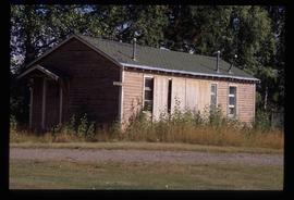
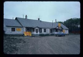
The item is a photograph depicting the old Red Rock schools. The buildings are weathered with peeling paint. One building is surrounded by debris. Annotation on reverse side of the photograph states, "River Edge Ranch, Red Rock schools looking west."
Image depicts a the teacherage building in Red Rock.
File contains slides depicting images of places in or around Red Rock, Hixon, and Woodpecker, B.C.
File contains slides depicting places in or around Red Rock, Hixon, and Woodpecker, B.C.
File contains slides depicting the Prince George region.
File contains slides depicting images from around the Northern area of B.C.
Image depicts a building in Reid Lake
File consists of notes and reproductions relating to Reid Lake Elementary School and Chief Lake Elementary School. Includes photographs depicting the old Reid Lake school building and various other old school sites (Sept. 2002).
The item is a photograph depicting the Reid Lake school at Reid Lake.
The item is a photograph depicting the old and current Reid Lake schools at Reid Lake.
The item is a photograph depicting the Reid Lake schoolyard at Reid Lake.
Photograph depicts a Rental and repair shop on 3rd Avenue.
Kent Sedgwick’s research subject files contain original research notes, interviews and oral histories, news clippings, and collected primary and secondary sources. The series also includes both original and reproduction photographs, audio recordings, and maps. The subject files primarily relate to the history, urban planning, and historical geography of the Central Interior of British Columbia, especially Prince George area and the East Line communities over the course of the 20th century. They also include extensive notes on geographic features, landscapes, interpretative trails, architectural history, industrial history, history of Western exploration and land survey, and the First Nations history of the region.
Image depicts a residential area with a playground somewhere in Mackenzie, B.C.
Photograph depicting a residential building surrounded by trees in an unknown location.
Photograph depicts a residential building at 1601 6th Avenue, the corner of 6th Avenue and Vancouver Street. Annotation on verso: "CUTE c-7, union, Vancouver/ 6th".
Photograph depicts a residential building at 1612 12th Avenue, the building was used as "Prince Realty". Annotation on verso: "1612 - 12th Ave., NW corner of Vancouver."
Photograph depicts a residential building at 1616 8th Avenue, on the corner of Vancouver Street. Annotation on verso: "1616 -8th Ave, NW corner of Vancouver".
Photograph depicts a residential building at 1617 8th Avenue. Annotation on verso: "1617 - 8th Ave".
Photograph depicts a residential building at 1625 4th Avenue. Annotation on verso: "Loedel proposal, 1625 - 4th, (see above)".
Photograph depicts a residential building at 1643 10th Avenue. Annotation on verso: "1643 - 10th Ave".
Photograph depicts a residential building at 1648 8th Avenue. Annotation on verso: "1648 - 8th, next to Rosel's".
Photograph depicts a residential building at 1651 5th Avenue. Annotation on verso: "1651 - 5th Ave".
Photograph depicts a residential building at 1661 10th Avenue. Annotation on verso: "1661 - 10th Ave".
Photograph depicts a residential building at 1722 7th Avenue. Annotation on verso: "1722 - 8th Ave".
Photograph depicts a residential building at 1770 5th Avenue. Annotation on verso: "1770 - 5th Ave".
Photograph depicts a residential building at 1795 10th Avenue. Annotation on verso: "1795 - 10th Ave, SE corner of, Winnipeg".
Photograph depicts a residential building at 1798 5th Avenue. Annotation on verso: "1798 - 5th Ave".
Photograph depicts a residential building at 825 Vancouver Street. Annotation on verso: "Van Horlick c-7".
Photograph depicts a residential building on the corner of Vancouver Street and 10th Avenue. Annotation on verso: "Trick house, Vancouver/ 10th".
Photograph depicts a residential building at the corner of 6th Avenue and Winnipeg Street. Annotation on verso: "NE corner, 6th / Winnipeg".
Photograph depicts a residential building in the North Thompson region.
Photograph depicts a residential building in the North Thompson region. The house is blue and surrounded by trees.
Photograph depicts residential buildings at 1662 and 1674 9th Avenue, one with a green roof and one with a metal roof. Annotation on verso: "1674 - 9th Ave green roof), 1662 - 9th Ave (metal roof)."
Photograph depicts residential buildings along 4th Avenue east of Winnipeg Street. Annotation on verso: "series on s. side of, 4th east from Winnipeg, (railway houses)".
Image depicts the interior of a church in Shelley, B.C.
Image depicts the interior of the church after its restoration, in Shelley, B.C.
File contains slides depicting Revelstoke.
The item is a photograph depicting Rhein Gold at 1177 3rd Avenue, Lot 17, Prince George. Wooden building with "For Rent" sign in one window.
The item is a photograph depicting Hab King, Harold Moffat, Ted Williams and a fourth man at the ribbon cutting ceremony for the opening of L. C. Gunn Park.
The item is a photograph depicting John Backhouse, Hab King, Harold Moffat, and Ted Williams at the ribbon cutting ceremony for the opening of L. C. Gunn Park.
The item is a photograph depicting John Backhouse, Hab King, Harold Moffat, and Ted Williams at the ribbon cutting ceremony for the opening of L. C. Gunn Park. Annotation on the reverse side of the photograph states, "L -> R Hab King, Harold Moffatt, Ted Williams, Mayor John Backhouse."
The item is a photograph depicting John Backhouse, Hab King, Harold Moffat and Ted Williams at the ribbon cutting ceremony for the opening of L. C. Gunn Park.
The item is a photograph depicting John Backhouse, Hab King, Harold Moffat, Ted Williams and a fifth man at the ribbon cutting ceremony for the opening of L. C. Gunn Park.
Image depicts the Esso gas station in Riske Creek, B.C.
Image depicts Riske Creek, B.C. The brown building on the left is the local school.
Image depicts the "Riske Creek General Store" in Riske Creek, B.C.