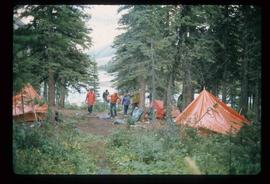
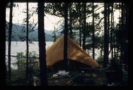
Image depicts a camp of people with Mt. Robson and the Berg Glacier in the background.
Image depicts a camp and what is likely Mt. Robson in the background.
Image depicts an unknown individual eating in a camp somewhere in South Tweedsmuir Provincial Park.
Image depicts a campsite somewhere near Berg Lake.
Image depicts group of people at a camp somewhere in Mt. Robson Provincial Park.
Image depicts a camp on the shore of a lake in South Tweedsmuir Provincial Park. The man sitting in the bottom right corner is possibly Kent Sedgwick.
Image depicts a group of individuals at camp somewhere in Mt. Robson Provincial Park.
The item is a photograph slide reproduction depicting the Cameron Street bridge in Prince George. The river is flooded with and ice jam reaching the height of the bottom of the bridge. Annotation on the slide states, "Cameron bridge 1916-1931."
The item is a photograph depicting the Cameron Street bridge plaque. The short write up details the construction and significance of the bridge. Annotations on reverse side of the photograph state, "169 words."
The item is a photograph depicting the Cameron Street bridge. The photograph is a reproduction of a photograph taken between 1917 and 1932. The picture depicts an ice jam with snow and ice along the Nechako River reaching the height of the base of the bridge. Annotations on the reverse of the photograph state, "Exp. Pl = 1922 p 986.9.9 Exp Pl = 16 Dec 1917 p 982 " 38.3 P 982.30.68 old bridge - can't be 1932."
The item is a photograph depicting the Cameron Street bridge. The photograph is a reproduction of a photograph taken between 1916 to 1931. The picture depicts the completed wooden Cameron Street bridge over the Nechako River. Annotations on the reverse side of the photograph state, "1st bridge between 1916 - 1934 983.7.13." Attached yellow sticky note states, "Note pilings in swing span. Ted Williams says the span was replaced with extension in 1922. So this photo is post - 1922."
The item is a photograph depicting the Caine building in Prince George.
Image depicts some cacti somewhere near Soda Creek, B.C.
Image depicts a nature trail along the Nechako River at Island Cache looking west with the cutbanks in the background. Map coordinates 53°55'36.2"N 122°45'11.8"W
Image depicts a cabin at an unknown location.
Image depicts a cabin somewhere in Mud River, B.C.
Image depicts a cabin at an uncertain location.
Image depicts a cabin somewhere in Mud River, B.C.
Photograph depicts Businesses in downtown in the North Thompson region, including a business 'Something Old & Something New'.
Photograph depicts Businesses in downtown in the North Thompson region, including a business '5 seasons, Sports Excellence'.
Photograph depicts Businesses in downtown in the North Thompson region, including a business called 'Something old & Something new'.
Photograph depicts Businesses in downtown in the North Thompson region, including a sign reading "Welcome to historic George Street" and a business called "Lizard River".
Photograph depicts Businesses in downtown in the North Thompson region, including a sign reading "Welcome to historic George Street" and Levi's jeans store.
Photograph depicts various businesses along 3rd Avenue. The businesses include the Europe Hotel and The Bay in the background. Annotation on verso: "left Europe Hotel, right shearer bldg".
Image depicts a street of businesses, possibly 3rd Avenue, in Prince George, B.C.
Image depicts the welcome sign in Burns Lake, B.C.
Image depicts a street in Burns Lake, B.C.
Image depicts a stretch of road somewhere at Burns Lake, B.C.
Image depicts Burns Lake, B.C.
The item is a photograph that depicts three veteran houses on Burden Street. Houses include beige siding, beige stucco and a white siding house.
The item is a photograph depicting a blue bunkhouse in the Upper Fraser, possibly from Crescent Spur. Annotation on reverse side of photograph states, "Crescent Spur bunkhouse?"
Image depicts bunkhouse, restaurant and store in Sinclair Mills, B.C. Map coordinates 54°01'17.4"N 121°40'53.0"W
Image depicts the upper end of the Bullion Pit in Likely, B.C.
Image depicts an old, half-collapsed house in Likely, B.C.. The slide labels it as "Bullion house."
Image depicts a bulldozer and truck in an unknown location.
Image depicts a stretch of road through the Bulkley Valley.
Image depicts a section of forest in the Bulkley Valley.
Image depicts a view of Bulkley Valley.
Image depicts the Bulkley River near Moricetown, B.C.
Image depicts numerous unknown individuals standing by the Bulkley River near Moricetown, B.C.
Image depicts a small group of people standing near the Bulkley River at Moricetown, B.C.
Image depicts the Bulkley River.
Image depicts a row of buildings in Upper Fraser, B.C. with the store (titled "Paradise") with a Pepsi sign. Map coordinates 54°07'09.1"N 121°56'47.0"W