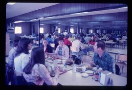
Image depicts the interior of a barn at a dairy farm located somewhere near Quesnel, B.C. Numerous unknown individuals are present.
Image depicts two unidentified individuals and a van on a farm at an uncertain location, possibly a place called Cypress Hill, with an atmometer and a sunshine recorder.
The item is a photograph depicting the plaque containing information on the history and significance of the cutbanks in Prince George, BC.
Image depicts an area of cut trees at Island Cache.
The item is a photograph depicting a crucifix from the church at Indian Reserve No. 2 in Shelley.
Image depicts a crowded cafeteria, most likely somewhere in Hudson's Hope, B.C. The slide is labelled "Camp at H.H."
Image depicts a backyard filled with various items piled against a shed in Island Cache.
Image depicts a large crowd of people on a section of the Heritage Trail on Cottonwood Island in Prince George, B.C.
Image depicts a crowd of people on a section of the Heritage Trail on Cottonwood Island in Prince George, B.C.
The item is a photograph depicting a crowd at the unveiling of the L. C. Gunn Park sign.
The item is a computer diskette including various word document versions of articles written by Kent Sedgwick. Annotation on the diskette states, "J. Kent Sedgwick Caledonia article and bibliography Word versions."
Image depicts a long line of people cross country skiing somewhere on Tabor Mountain in Prince George, B.C.
Image depicts an unidentified man cross country skiing somewhere on Tabor Mountain in Prince George, B.C.
Image depicts a view of the Crooked River Provincial Park.
The item is a map depicting the Crooked River Provincial Forest area. Sections of the map are highlighted and coordinates are annotated in ink.
Image depicts a group of unidentified individuals walking along a crevasse filled ridge somewhere in the vicinity of Smithers, B.C. The slide also labels it as a "drift ridge."
Image depicts a crevasse filling ridge somewhere in the Bulkley Valley, B.C.
Image depicts a man attaching a logging trailer to a crane on a wooden structure to stack the trailer on the truck. A Crestbrook Forest Industries sawmill is located in the background.
Image depicts a logging truck with its trailer being attached on top of it. A Crestbrook Forest Industries sawmill is located in the background.
Image depicts a row of houses and the side of a train in Crescent Spur, B.C.
Image depicts the railway running near Crescent Spur in the Rocky Mountain Trench.
Image depicts what appears to be a small mill in the community of Crescent Spur, B.C.
Image depicts a church school in the community of Crescent Spur, B.C.
Image depicts a beehive burner in the community of Crescent Spur, B.C.
Image depicts the community of Crescent Spur, B.C.
Image depicts a creek near Quesnelle Forks, B.C.
Image depicts a creek near Iron Road North, north of Woodpecker, B.C.
The item is a photograph depicting the front and side of the log Cranbrook Mills schoolhouse. Building is weathered with a sagging roof and collapsing wall.
The item is a photograph depicting the front and side of the log Cranbrook Mills schoolhouse. Building is weathered with a sagging roof and collapsing wall. Annotation on reverse side of photograph states, "Cranbrook Mills, Cranbrook Hill School. Courtesy: Kent Sedgwick. 215."
The item is a photograph depicting the front and side of the log Cranbrook Mills schoolhouse. Building is weathered with a sagging roof.
The item is a photograph depicting the front of the log Cranbrook Mills schoolhouse. Building is weathered.
The item is a photograph depicting the front of the log Cranbrook Mills schoolhouse. Building is weathered. Annotation on reverse side of photograph states, "Kodak Gold 200."
The item is a photograph depicting the front and side of the log Cranbrook Mills schoolhouse. Building is weathered with a sagging roof and collapsing wall.
The item is a photograph depicting the front of the log Cranbrook Mills schoolhouse. Building is weathered.
Image depicts an old, collapsing cabin at an uncertain location; possibly Woodpecker B.C.
The item is a photograph negative of a man and woman sitting in front of a house. They are dressed in formal attire and are drinking what appears to be a glass of wine.
The item is a map depicting the area surrounding the Cottonwood River in the Cariboo Land District. Various annotations are mad in pen on the map.
Image depicts a the Cottonwood Island Nature Park sign and map in Prince George, B.C.
Image depicts Elmer Mercier, a former mayor of Prince George, B.C., cutting the ribbon to open Cottonwood Park's Heritage Trail.
Image depicts a crowd of people in Cottonwood Park in Prince George, B.C.
Image depicts a nature trail in Cottonwood Island Park by a beehive burner. Map coordinates 53°55'23.6"N 122°43'53.8"W
Image depicts a couple walking through a nature trail in Cottonwood Island Park. Map coordinates 53°55'23.6"N 122°43'53.8"W