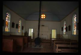
The item is a photograph of the front and side of Sacred Heart Catholic Cathedral at 887 Patricia Boulevard, Prince George.
The item is a photograph depicting a workshop in the rural Prince George area.
The item is a 35 mm photograph depicting a workshop in the rural Prince George area.
Image depicts a small, ruined shed somewhere in the Okanagan Kettle Valley.
Image depicts the ruined interior of a mansion at an unknown location.
Image depicts several old, ruined cars and an unknown individual in Island Cache.
Image depicts a small foot bridge at an unknown location. The slide is simply labelled "Rudi's Bridge."
Image depicts the Royal Canadian Legion building on 7th Ave and the Inn of the North Coast Hotel in the background. Map coordinates 53°54'50.6"N 122°44'56.1"W
Image depicts two rows of houses in an unknown location.
Image depicts a row of houses in Upper Fraser, B.C. Map coordinates 54°06'51.6"N 121°56'26.3"W
Image depicts a row of houses; it is possibly in Prince Rupert, B.C.
Photograph depicts Rosel's restaurant at 1624 7th Avenue. Rosel's restaurant was owned and operated by Wilfred and Rosel Vogt from 1981 to 1997. The building was built in 1916 and was originally owned by Dr. Carl Ewart and later owned by Hubert King of Wilson, King and Company, the oldest law firm in Prince George, after 1946. The building is now a designated heritage building.
The item is a DVD-R containing two video files taking up a total of 2GB.
Image depicts a view of McBride in the Rocky Mountain Trench.
Image depicts the peak of the Rocher de Boule mountain from Hazelton, B.C.
Image depicts an old log cabin with the sign "Robin Hood Flour" on it at an uncertain location. It is possibly at the 153 Mile House.
Image depicts a road with what appears to be a junkyard to the right of the image, likely located somewhere in Seton Portage, B.C.
Image depicts what appears to be a small, narrow river, and mounds of snow. The location is uncertain.
Image depicts the "Riske Creek General Store" in Riske Creek, B.C.
Image depicts Riske Creek, B.C. The brown building on the left is the local school.
Image depicts the Esso gas station in Riske Creek, B.C.
The item is a photograph depicting Rhein Gold at 1177 3rd Avenue, Lot 17, Prince George. Wooden building with "For Rent" sign in one window.
Image depicts the interior of a church in Shelley, B.C.
Image depicts the interior of the church after its restoration, in Shelley, B.C.
Photograph depicts residential buildings along 4th Avenue east of Winnipeg Street. Annotation on verso: "series on s. side of, 4th east from Winnipeg, (railway houses)".
Photograph depicts residential buildings at 1662 and 1674 9th Avenue, one with a green roof and one with a metal roof. Annotation on verso: "1674 - 9th Ave green roof), 1662 - 9th Ave (metal roof)."
Photograph depicts a residential building in the North Thompson region.
Photograph depicts a residential building in the North Thompson region. The house is blue and surrounded by trees.
Photograph depicts a residential building at the corner of 6th Avenue and Winnipeg Street. Annotation on verso: "NE corner, 6th / Winnipeg".
Photograph depicts a residential building on the corner of Vancouver Street and 10th Avenue. Annotation on verso: "Trick house, Vancouver/ 10th".
Photograph depicts a residential building at 825 Vancouver Street. Annotation on verso: "Van Horlick c-7".
Photograph depicts a residential building at 1798 5th Avenue. Annotation on verso: "1798 - 5th Ave".
Photograph depicts a residential building at 1795 10th Avenue. Annotation on verso: "1795 - 10th Ave, SE corner of, Winnipeg".
Photograph depicts a residential building at 1770 5th Avenue. Annotation on verso: "1770 - 5th Ave".
Photograph depicts a residential building at 1722 7th Avenue. Annotation on verso: "1722 - 8th Ave".
Photograph depicts a residential building at 1661 10th Avenue. Annotation on verso: "1661 - 10th Ave".
Photograph depicts a residential building at 1651 5th Avenue. Annotation on verso: "1651 - 5th Ave".
Photograph depicts a residential building at 1648 8th Avenue. Annotation on verso: "1648 - 8th, next to Rosel's".
Photograph depicts a residential building at 1643 10th Avenue. Annotation on verso: "1643 - 10th Ave".
Photograph depicts a residential building at 1625 4th Avenue. Annotation on verso: "Loedel proposal, 1625 - 4th, (see above)".
Photograph depicts a residential building at 1617 8th Avenue. Annotation on verso: "1617 - 8th Ave".
Photograph depicts a residential building at 1616 8th Avenue, on the corner of Vancouver Street. Annotation on verso: "1616 -8th Ave, NW corner of Vancouver".
Photograph depicts a residential building at 1612 12th Avenue, the building was used as "Prince Realty". Annotation on verso: "1612 - 12th Ave., NW corner of Vancouver."
Photograph depicts a residential building at 1601 6th Avenue, the corner of 6th Avenue and Vancouver Street. Annotation on verso: "CUTE c-7, union, Vancouver/ 6th".
Image depicts a residential area with a playground somewhere in Mackenzie, B.C.
Photograph depicts a Rental and repair shop on 3rd Avenue.
Image depicts a building in Reid Lake