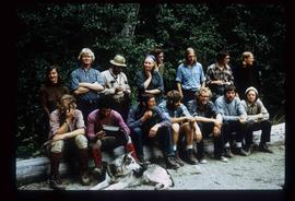
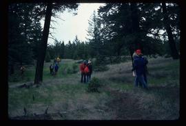
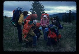
Image depicts a group of people hiking, possibly somewhere near Riske Creek, B.C.
Image depicts a group of hikers on a hiking trail.
Image depicts a group of hikers examining something on the ground, most likely the small pink flower that is barely visible in the grass. The location is possibly near Riske Creek.
Image depicts a group of people in a kitchen area of the Mueller home in Sinclair Mills, B.C.; the man in the grey shirt is Ray Mueller displaying his taxidermy collection. Map coordinates 54.014188, -121.676973
Image depicts a group of people in a kitchen area of the Mueller home in Sinclair Mill, B.C.; the man in the grey shirt is Ray Mueller displaying his taxidermy collection. Map coordinates 54.014188, -121.676972
Image depicts a large group of people in a room at an uncertain location in the Peace River Region.
The photograph depicts seven men and women on the railway turntable at the CN Railyard in Prince George, B.C. Reproduction of photograph from 1984.
Image depicts a group of individuals standing on the corner of 3rd Ave in Prince George, B.C.
Image depicts numerous individuals who appear to be searching among the rocks on a ledge at an uncertain location in the Peace River Region.
Image depicts the hiking group. Kent Sedgwick is located in the back row, third from the left with a pipe.
Item is a photograph depicting Thomas Norton, Kent Sedgwick and a third man.
Item is a photograph depicting Thomas Norton, Warren Meyer, Trelle Morrow, Kent Sedgwick and a fifth man.
Image depicts the Grand Trunk Pacific railway roundhouse in Prince George, B.C.
Image depicts the GTP roundhouse in Prince George, B.C.
Image depicts the Grand Trunk Pacific railway roundhouse in Prince George, B.C.
Image depicts the interior of the GTP roundhouse in Prince George, B.C.
Image depicts machinery in the GTP roundhouse in Prince George, B.C.
The item is a CD-R containing various jpg. photographs and a PowerPoint presentation about the Grand Trunk Pacific Railway done by Kent Sedgewick.
The photograph depicts the Grand Trunk Pacific Railyard roundhouse and water tower in Prince George, B. C. Reverse side of photograph states, "Photo Credit: Fort George Museum." Reproduction from [192-?].
The item is a photograph of Gundy's News and an empty commercial building on 3rd Avenue in Prince George.
The item is a photograph depicting the exterior view of the front of Gundy's News Supply Ltd. at 1244 3rd Avenue, Prince George. Part of the Columbus Hotel and Pub at 1250 3rd Avenue and a vacant building at 1232 3rd Avenue can be seen. There is a woman standing outside one of the businesses. Photograph originally taken between 1978 and 1979.
The item is a photograph of the H&R Block building and an empty commercial building on 3rd Avenue in Prince George.
Image depicts a bridge in Hagwilget, B.C.
Image depicts a church on a hill in Hagwilget, B.C.
Image depicts Haldi Lake near Prince George, B.C.
Image depicts an old, half-collapsed building at an uncertain location.
Image depicts a house on Blackwater Road.
Image depicts a hallway in an unknown building somewhere in Wells, B.C.
The photograph depicts a hallway with windows at the interior of the CN roundhouse in Prince George, BC. Reproduction of photograph from 1984.
Image depicts a hammer sitting in dirt at an uncertain location.
Image depicts a man and woman shaking hands in a building at an uncertain location, possibly in Cottonwood Park. The man standing behind the two is possibly Elmer Mercier, a former mayor of Prince George, B.C.
Image depicts the new Hansard Bridge. Map coordinates 54°04'57.9"N 121°51'10.1"W
Image depicts the Hansard railroad bridge taken from the new Hansard vehicle bridge. Map coordinates 54°04'58.1"N 121°50'58.0"W
Image depicts the Hansard railroad bridge looking west. Map coordinates 54°04'37.9"N 121°50'46.3"W
Image depicts a road leading into a First Nations' Reserve at the head of Harrison Lake.
Image depicts Glenview Drive near the Hart Highway in Prince George, B.C.
Image depicts a neighbourhood on the Hart Highway in Prince George, B.C.
The item is a photograph depicting the weathered Hart Highway schoolhouse. The school is shown at its relocation to the Myatovic farmland. Annotation on reverse side of photograph states, "east building s. end looking NE - from Hart Hwy."
The item is a photograph depicting the weathered Hart Highway schoolhouse. The school is shown at its relocation to the Myatovic farmland. Annotation on reverse side of photograph states, "east building, n. end, view se." Accompanying note with photograph states, "Shady Valley relocation to Myatovic farm property."
The item is a photograph depicting three weathered schoolhouses lined next to each other. The schools are from Hart Highway, Shady Valley, and Westlake. They are shown at their relocation to the Myatovic farmland. Annotation on reverse side of photograph states, "Myatovic property, N side looking west - left - Hart Hwy, Mid - Shady V, right - West L."
The item is a photograph depicting three weathered schoolhouses lined next to each other. The schools are from Hart Highway, Shady Valley, and Westlake. They are shown at their relocation to the Myatovic farmland. Annotation on reverse side of photograph states, "Myatovic prop. s. side, looking north west - ends where mud room joined them - left - West L, mid sc is original Shady V, right - Hart Hwy."
Image depicts a "box barn" on the historic Hat Creek Ranch site north of Ashcroft, B.C.
Image depicts the McLean Cabin, built in 1861, which belonged to a retired Hudson's Bay Chief trader named Donald McLean, who was shot and killed while part of a posse that was searching for the murderers of a survey party. It is located at the historic Hat Creek Ranch site north of Ashcroft, B.C.