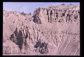
Image depicts an eroding rock face at an uncertain location.
Image depicts a building surrounded by a tall, circular enclosure somewhere on Haida Gwaii, B.C.
Image depicts employee houses on mill site in Giscome, B.C. Tug boats are in the foreground on the right. Map coordinates 54°04'23.4"N 122°22'16.9"W
Image depicts an earth flow north of Stone Creek, B.C.
Image depicts Eaglet Lake in the winter taken from Giscome, B.C. Map coordinates 54°04'20.9"N 122°21'53.1"W
Image depicts the creek flowing into Eaglet Lake. A grey area of hill on the right side of the image appears to be the Giscome Quarry. Map coordinates 54°04'26.2"N 122°22'04.3"W
Image depicts an eastern view over Eaglet Lake.
Image depicts the site of Giscome's first quarry, with Eaglet Lake located in the foreground.
Image depicts the site of Giscome's first quarry, with a train passing by and Eaglet Lake located in the foreground.
Image depicts a lake at an uncertain location, likely Eaglet Lake.
Image depicts Eaglet Lake, north-east of Prince George, B.C.
Image depicts the Dunlevy Creek area somewhere near Dawson Creek, B.C. The slide is simply labelled "Dunlevy irrigation" for uncertain reasons.
Image depicts a view of Duffey Lake Provincial Park, looking west over Duffey Lake.
Image depicts a view of Duffey Lake Provincial Park, looking east over Duffey Lake.
Image depicts a large flock of ducks in a field full of water at an unknown location.
Image depicts a driveway cordoned off by a red mesh material in Newlands, B.C. The address of the house is labelled 31951, and the name listed is "Fauchers." Map coordinates 54°06'47.8"N 122°08'22.4"W
Image depicts a number of identical buildings and vehicles at "Driftwood Creek" in the Driftwood Canyon Provincial Park.
Image depicts Downton Lake, the Lajoie Dam reservoir.
Image depicts an old, unused log cabin somewhere in Dome Creek, B.C.
Image depicts a log cabin somewhere in Dome Creek, B.C.
Image depicts what is possibly the CN Station in Dome Creek, B.C.
Image depicts the CN Station in Dome Creek, B.C.
Image depicts a pair of dogs in a forest, possibly somewhere near Woodpecker, B.C.
Image depicts two dogs and numerous chickens in a yard at Island Cache.
Image depicts an unknown individual and a dog on a bridge over what is possibly the Robson River.
Image depicts a dog standing on a path through the woods somewhere in Carp Lake Provincial Park.
Image depicts a dog in a forest, possibly somewhere near Woodpecker, B.C.
Image depicts a ferry docked at Haida Gwaii, B.C.
Image depicts numerous docked boats in Prince Rupert, B.C.
Image depicts numerous docked boats somewhere in Prince Rupert, B.C.
Image depicts a dock on a lake in Carp Lake Provincial Park, possibly War Lake.
Image depicts a dock in Prince Rupert, B.C.
Image depicts the "Divides Lake Waterfall" as well as a man in front of a helicopter in the foreground.
Image depicts the "Divides Lake Waterfall."
Image depicts Divide Lake.
Image depicts a ditch of water at an uncertain location.
Image depicts a section of disturbed ground at an unknown location.
Image depicts an area of disturbed ground, most likely due to a landslide, at an unknown location.
Image depicts a large section of disturbed ground at an unknown location.
Image depicts an area of disturbed ground, most likely due to a landslide, at an unknown location.
Image depicts a dirt road leading through a forest.
Image depicts a dirt road leading through a forest with what appears to be an area for turning around at the end.
Image depicts a dirt road and a possibly abandoned building at an uncertain location.
Image depicts a dirt road leading through numerous trees toward a mountain. The location is uncertain, likely on the way to Longworth, B.C.
Image depicts an old house for sale surrounded by overgrown bushes in Upper Fraser, B.C. Map coordinates 54°07'15.0"N 121°57'02.0"W