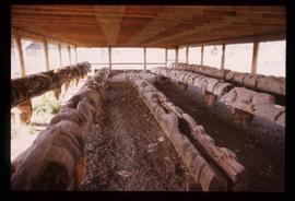
Image depicts a large gathering of people in the interior of a First Nations' longhouse located in the historical village of 'Ksan in Hazelton, B.C.
Image depicts the entrance to the historical village of 'Ksan in Hazelton, B.C.
Image depicts the historical village of 'Ksan near Hazelton, B.C.
Image depicts the 'Ksan historical village in Hazelton, B.C.
Image depicts the historical village of 'Ksan in Hazelton, B.C.
Image depicts a group of people in the historical village of 'Ksan near Hazelton, B.C.
Image depicts a Knox United Church at an uncertain location, though possibly in either Hixon or Woodpecker, B.C.
Image depicts a row of totem poles in Kitwanga, B.C.
Image depicts a totem pole in Kitwanga, B.C.
Image depicts an old Hudson Bay Company house in Kitwanga, B.C.
Image depicts an old Hudson Bay Company house, with a totem pole in the foreground, in Kitwanga, B.C.
Image depicts the CN Rail station located in Kitwanga, B.C.
Image depicts an Anglican church and a bell tower in Kitwanga.
Image depicts a row of totem poles in Kitwancool, B.C.
Image depicts a totem pole in Kitwancool, B.C.
Image depicts a shed somewhere in Kitwancool Lake, B.C.
Image depicts several old totem poles on their sides in Kitwancool, B.c.
Image depicts two old, overgrown and collapsing buildings, as well as a metal frame; it is located somewhere in Kitwancool, B.C.
Image depicts numerous houses in Kitwancool, B.C.
Image depicts the interior of an old, collapsing log building in Kitwancool, B.C.
Image depicts an Anglican church in Kitwancool Lake, B.C.
Image depicts numerous individuals passing in front of the Bay in Kitimat, B.C.
Image depicts a view of the forest and lake around Kitimat, B.C.
Image depicts a row of houses somewhere in Kitimat, B.C.
Image depicts a man holding two fish on a dock in Kitimat, B.C.
Image depicts the interior of a mall somewhere in Kitimat, B.C.
Image depicts a harbour in Kitimat, B.C.
Image depicts numerous docked boats in Kitimat, B.C.
Image depicts numerous businesses, such as the Bay, Overwaitea, and Dairy Queen, somewhere in Kitimat, B.C.
Image depicts several buildings in Kitimat, with the Bay being the tall one on the left.
Image depicts numerous docked boats, as well as many houses on the shore in the background; located in Kitimat, B.C.
Image depicts what is possibly the Alcan smelter in Kitimat, B.C.
Image depicts a view of the area surrounding Kitimat, with power-lines in the foreground the city partially visible in the distance.
Image depicts the Kiteen River at Dragon Lake near Aiyansh, B.C.
Image depicts the mouth of the Kispiox River.
Image depicts numerous totem poles in Kispiox, B.C.
Image depicts a totem pole beside the grave marker of the Chief Lu-dal-da-zuatz, in Kispiox, B.C.
Image depicts an old house in Kispiox, B.C.
Image depicts an old, partially burnt totem pole in Kispiox, B.C.
Image depicts the King George V School in Prince George, which was demolished sometime around 2006 and Duchess Park Secondary School was built in its place.
Image depicts a van on a narrow road, likely the Kettle Valley Trail.
Image depicts a woman walking along a trail somewhere in Kettle Valley, B.C.
Image depicts a view of Kettle Valley, with a bridge of the old Kettle Valley Rail Road visible on a slope.