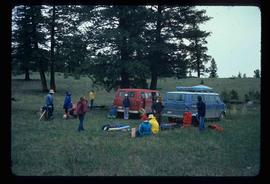
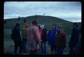
Image depicts the canoe group around a campfire at the head of Indianpoint Lake.
Image depicts the cemetery in Hazelton, B.C.
Image depicts a tombstone in the cemetery in Hazelton, B.C.
Image depicts the cemetery in Hazelton, B.C.
Image depicts a beaver dam somewhere in Hazleton, B.C.
Image depicts Hazelton, B.C.
Image depicts the road leading to the historic Hat Creek Ranch site north of Ashcroft, B.C. Several individuals are sitting on the front porch of the Ranch house.
Image depicts the front of the ranch house on the historic Hat Creek Ranch site north of Ashcroft, B.C.
Image depicts several individuals sitting on the front porch of the Ranch house on the historic Hat Creek Ranch site north of Ashcroft, B.C.
Image depicts numerous individuals standing near the Ranch house and McLean Cabin on the historic Hat Creek Ranch site north of Ashcroft, B.C.
Image depicts a "box barn" on the historic Hat Creek Ranch site north of Ashcroft, B.C.
Image depicts a road leading into a First Nations' Reserve at the head of Harrison Lake.
Image depicts the Hansard railroad bridge looking west. Map coordinates 54°04'37.9"N 121°50'46.3"W
Image depicts the Hansard railroad bridge taken from the new Hansard vehicle bridge. Map coordinates 54°04'58.1"N 121°50'58.0"W
Image depicts the new Hansard Bridge. Map coordinates 54°04'57.9"N 121°51'10.1"W
Image depicts a hammer sitting in dirt at an uncertain location.
Image depicts a house on Blackwater Road.
Image depicts an old, half-collapsed building at an uncertain location.
Image depicts Haldi Lake near Prince George, B.C.
Image depicts a church on a hill in Hagwilget, B.C.
Image depicts a bridge in Hagwilget, B.C.
Image depicts numerous individuals who appear to be searching among the rocks on a ledge at an uncertain location in the Peace River Region.
Image depicts a group of hikers examining something on the ground, most likely the small pink flower that is barely visible in the grass. The location is possibly near Riske Creek.
Image depicts a group of hikers on a hiking trail.
Image depicts a group of people hiking, possibly somewhere near Riske Creek, B.C.
Image depicts a group of people and two vans, apparently preparing to set out on a hike somewhere near Riske Creek, B.C.
Image depicts a group of hikers listening to a man, possibly a guide, speak. The location is possibly near Riske Creek, B.C.
Image depicts a group of hikers, possibly somewhere near Riske Creek, B.C.
Image depicts a group of people standing near a river. A glacier is visible in the background.
Image depicts a group of individuals and a bus with words that read: "Prince George Limousine & Charter." The river in the background is possibly the Peace River, and the location is possibly somewhere near Fort St. John, B.C.
Image depicts an aerial view of a grooved region of land at an uncertain location.
Image depicts an aerial view of grooves in the land near the Fraser River, possibly caused by glaciers.
Image depicts a view of grooves in the land near the Fraser River, possibly caused by glaciers.
Image depicts an aerial view of a grooved region of land at an uncertain location.
Image depicts a small graveyard at an uncertain location.
Image depicts layers of gravel at the BCR site in Prince George, B.C.
Image depicts the grave of W.L. Meason in the upper Fraser Canyon.
Image depicts Grassy Plains, B.C.
Image depicts a large, electric shovel at a mine site somewhere in Granisle, B.C.
Image depicts a drill for blasting holes at a mine site somewhere in Granisle, B.C.
Image depicts numerous bags of blasting powder at a mine site somewhere in Granisle, B.C.
Image depicts an 80 tonne truck at a mine site somewhere in Granisle, B.C.
Image depicts an example of "typical housing" in Granduc, near the Granduc Mine and located north of Stewart, B.C.