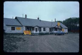
Photograph depicts residential buildings at 1662 and 1674 9th Avenue, one with a green roof and one with a metal roof. Annotation on verso: "1674 - 9th Ave green roof), 1662 - 9th Ave (metal roof)."
Photograph depicts residential buildings along 4th Avenue east of Winnipeg Street. Annotation on verso: "series on s. side of, 4th east from Winnipeg, (railway houses)".
Image depicts the interior of a church in Shelley, B.C.
Image depicts the interior of the church after its restoration, in Shelley, B.C.
The item is a photograph depicting Rhein Gold at 1177 3rd Avenue, Lot 17, Prince George. Wooden building with "For Rent" sign in one window.
The item is a photograph depicting Hab King, Harold Moffat, Ted Williams and a fourth man at the ribbon cutting ceremony for the opening of L. C. Gunn Park.
The item is a photograph depicting John Backhouse, Hab King, Harold Moffat, and Ted Williams at the ribbon cutting ceremony for the opening of L. C. Gunn Park.
The item is a photograph depicting John Backhouse, Hab King, Harold Moffat, and Ted Williams at the ribbon cutting ceremony for the opening of L. C. Gunn Park. Annotation on the reverse side of the photograph states, "L -> R Hab King, Harold Moffatt, Ted Williams, Mayor John Backhouse."
The item is a photograph depicting John Backhouse, Hab King, Harold Moffat and Ted Williams at the ribbon cutting ceremony for the opening of L. C. Gunn Park.
The item is a photograph depicting John Backhouse, Hab King, Harold Moffat, Ted Williams and a fifth man at the ribbon cutting ceremony for the opening of L. C. Gunn Park.
Image depicts the Esso gas station in Riske Creek, B.C.
Image depicts Riske Creek, B.C. The brown building on the left is the local school.
Image depicts the "Riske Creek General Store" in Riske Creek, B.C.
Image depicts a river and a hillside at an unknown location.
Image depicts a river, possibly the Nechako, in Prince George, B.C. Possibly taken from the Foothills Bridge.
Image depicts a river at an uncertain location.
Image depicts a river, possibly the Fraser, at an uncertain location.
Image depicts a river at an uncertain location.
Image depicts what is possibly a section of the Tseax River.
Image depicts a man in a canoe on a river somewhere in South Tweedsmuir Provincial Park. The man is possibly Kent Sedgwick.
Image depicts a canoe on a river somewhere in South Tweedsmuir Provincial Park.
Image depicts a river, possibly either the Nechako or the Fraser, and a mountain range from an unknown location.
Image depicts a river on the left of the image and a range of mountains in the distance, located somewhere near Bralorne, B.C.
Image depicts what appears to be a small, narrow river, and mounds of snow. The location is uncertain.
Image depicts a ferry on a river, possibly the Fraser River in the Lillooet area.
Image depicts a river full of logs, somewhere near Bralorne, B.C.
Image depicts a river with dense trees on either side.
The item is a photograph depicting a river valley.
The item is a photograph depicting a boat with multiple people going down the Quesnel River.
The item is a photograph depicting the riverside of the Fraser River in Fort George Canyon.
The item is a photograph depicting Caine Lumber Co. Ltd. during the Nechako River flood on 20 December 1948. Annotation on the front of the photograph states, "opposite C.L.C. Ltd Garage Riverside Ave.." Annotation on reverse side of photograph states, "Nechako Ice Flood. Dec. 20/48 from Garage Riverside Ave. Caine Lbr Co Ltd Looking East"
The item is a photograph depicting Riverside Avenue during the Nechako River flood on 20 December 1948. Annotation on the front of the photograph states, "River Avenue water level." Annotation on reverse side of photograph states, "Nechako River Ice Flood on Riverside Ave. Dec 20th, 1948 - Looking East from office of Caine Lbr Co Ltd."
Image depicts a road with what appears to be a junkyard to the right of the image, likely located somewhere in Seton Portage, B.C.
Image depicts a mountain located somewhere along the Skeena River, and a road alongside it.
Image depicts a road somewhere in the Upper Fraser Canyon, and a view of the hills and trees.
The item is a photograph depicting a dirt road in Ten Mile Park, BC. Annotation on reverse side of photograph states, "in 10 ml park."
Image depicts a ditch near a road somewhere in Woodpecker B.C.
Image depicts a road somewhere in Woodpecker, B.C.
Image depicts a water-filled ditch near a road somewhere in Woodpecker B.C.
Image depicts a north view of a road somewhere in Woodpecker, B.C.
Image depicts a road located somewhere near Birken, B.C.
Image depicts the road leading to Hyder, which is on the other side of the Alaska-British Columbia border and is just a little south-west of Stewart, B.C.
Image depicts the dirt road leading to Keithley Creek.
Image depicts a road leading to Prince Rupert, B.C.