File consists of the 1904 edition of a textbook by N. Hawkins entitled "New Catechism of the Steam Engine with Chapters on Gas, Oil and Hot Air Engines".
Postcard depicts Field station in the Rockies. Man standing on the left with a bowler hat was Chris McGregor, a professional (mining?) engineer. Earliest frank seen for the postcard was in July 1906.
File consists of an original 1909 provincial publication entitled "British Columbia, the Mineral Province of Canada, being a Short History of Mining in the Province, a Synopsis of the Mining Laws in force, Statistics of Mineral Production to Date, and a Brief Summary of the Progress of Mining during 1908". Includes inset plates and pull-out graphs.
Government map depicts railway lands, lands "disposed of", grazing leases, and timber berths. Shows the British Columbia 'railway belt' running from Greater Vancouver to Field, B.C.
Series consists of research material regarding rail freight in British Columbia and in general. Includes information about freight statistics, freight customers in BC, freight revenue, less-than-carload service, types of freight loads, freight loading and discharging devices, and intermodal freight. Also includes information on the rail transport of coal, coke fuel, ore, lumber, pulp and paper, potash, sulfur, cement, gypsum, grain, fish, chemicals, petroleum, automobiles, and livestock.
Postcard depicts the first crossing of the Kicking Horse.
Postcard depicts a snow slide scene, west of Calgary in the Canadian Rockies with a snow plow clearing the railroad of an avalanche. Three-colour process.
Postcard depicts Mt. Stephen near Field, BC
Postcard depicts a view of the CPR line in B.C.
Postcard depicts a snow slide scene in the Canadian Rockies.
Postcard depicts Lower Kicking Horse Canyon near Golden on the Canadian Pacific Railway in the Canadian Rockies.
Postcard depicts Mt. Stephen and the CPR's hotel in Field, BC
Plan depicts the proposed location and layout for the Canadian Northern Pacific terminal at Kamloops on the Kamloops-Lumby branch.
Postcard depicts Mt. Stephen and a Hotel at Field, BCin the Canadian Rockies.
Postcard depicts a passenger train near Field, BC
Architectural plan depicts a proposed standard 10 stall engine house with annex for machine shop and boiler room to be erected at Kamloops, BC.
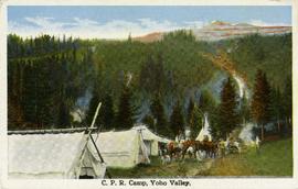
Postcard taken along the CPR line, at a camp in Yoho Valley.
Postcard depicts the passage through the shoulder of Mt. Stephen.
Postcard depicts a CPR passenger train near a summit of the Rocky Mountains.
Plan depicts Granville Island industrial sites in False Creek, Vancouver. Shows revised trackage from 1955 annotated in colour by Davies.
Postcard depicts a spiral tunnel near Field, in which trains make a complete turn around the Canadian Rockies. One of two spiral tunnels, and the first of this system introduced on the continent. The greatest pieced of tunnelling ever attempted in Canada. Cost 1,5000,000. Time of work: 20 months. 75 car-loads of dynamite used.
Postcard depicts Mount Field from a CPR hotel in Field, Canadian Rocky Mountains.
Postcard depicts Kicking Horse Canyon, Field, A.B.. on the CPR line.
Postcard depicts 'The Gap," the entrance to the Rockies.
Postcard depicts Kicking Horse Canyon, Field, BC on the CPR line.
Postcard depicts Mt. Stephen and Field, BC
Postcard depicts Mt. Stephen in Field, BC
Plan depicts the location of buildings occupied by the Northern Construction Company on the old Kamloops Station ground.
File consists of a British Columbia Provincial Government publication by W.P. Hinton entitled "Report on the Pacific Great Eastern Railway: Its Organization and Operation, with Recommendations".
Postcard depicts Cathedral Mountain on the Canadian Pacific Railway.
Contour plan shows layout of a water tunnel near Lyon's Creek in the CNR Clearwater subdivision.
Map depicts passenger routes on the Canadian Pacific Railway and its connecting lines in 1925.
Plan depicts the proposed CNR rail yard layout in Kelowna. A later plan, dated May 30th 1925, shows drastically reduced trackage and no barge slip.
Plan depicts a proposed location for a CNR station and crossing in Kelowna.
Plan depicts a section, profile, and contour plan of the fill of the Lyon Creek Trestle bridge in the Clearwater CNR subdivision.
Plan depicts the location of the Lyon Creek Bridge and borrow pit on the CNR Clearwater subdivision.
Plan depicts architectural drawings of the Canadian National Railway station in Kamloops. Includes an elevation of the building and floor plans.
Map depicts railway lines in the state of Washington, including those crossing over the border into British Columbia.
Plan depicts sections, elevations, and floor plans for the addition to the Kamloops roundhouse.
Architectural block plan depicts a proposed addition to the CNR roundhouse in Kamloops.
File consists of an original "Operating rules [for] Canadian National Railways, Grand Trunk Railway System, Duluth, Winnipeg and Pacific Railway, Central Vermont Railway, dated July 1st, 1929".
Postcard taken at the Laggan Subdivision, the most famous photograph location on the CPR system due to its official photographer, Nicholas Morrant, 1910-1986. Possibly a 1920's view. From 1978, this location became known as 'Morant's Curve.' This view was a rarity in showing no train on the track.
Postcard depicts the Lake Louise CPR depot.
Postcard depicts Cathedral Mountain.
Postcard taken on Field Hill, along the CPR line.
Postcard depicts a train exiting a tunnel along the CPR line.
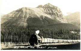
Postcard depicts the Great Divide between Alberta and British Columbia, along the CPR line.
Postcard depicts Field Hill at Yoho National Park.
Postcard depicts Mt. Stephen and Field, BC
Postcard depicts Kicking Horse Canyon.

