Map depicts the Abbotsford area, including railway lines.
Government map depicts railway lands, lands "disposed of", grazing leases, and timber berths. Shows the British Columbia 'railway belt' running from Greater Vancouver to Field, B.C.
Map depicts railways in British Columbia, with insets for the Lower Mainland and the Kootenays.
Map depicts Canadian railways in operation at 2011.
Map depicts the Canadian National Railway system, including trackage for the Central Vermont Railway, the Detroit & Toledo Shore Line Railroad, the Grand Trunk Western Railroad, the Duluth Winnipeg & Pacific Railway, and the Northern Alberta Railway.
Map depicts the CNR system in Canada and the United States and all of its connecting lines, including the Central Vermont Railway, the Grand Trunk Western Railroad, and the Duluth Winnipeg & Pacific Railway.
Map depicts passenger routes on the Canadian Pacific Railway and its connecting lines in 1925.
Map depicts the city of Vancouver and its railways.
Real estate map depicts the areas around Coquitlam, Port Coquitlam, and Port Moody, including rail trackage.
Map depicts the Cowichan Lake area, including rail trackage for the Western Forest Industries Logging Railway, the Canadian National Railway, and the BC Forest Products Logging Railway.
Map depicts the Cowichan Lake area, including rail trackage for the Western Forest Industries Logging Railway, the Canadian National Railway, and the BC Forest Products Logging Railway.
The David Davies Railway Collection encompasses all facets of railway history specifically in the province of British Columbia and the Yukon territory. The collection consists of research material accumulated over the course of more than fifty years, and includes monographs, periodicals, articles, clippings, railway timetables, photographs, maps and plans, and excerpts. Material covers public, tourist, and private (industrial) railways, including: CPR, KVR, E&N; CNR, CNoR, GTPR; and PGER, BCR. The collection excludes material regarding streetcar systems and rapid transit, but includes long distance electric interurbans.
Map depicts historical rail lines in the BC lower mainland, including trackage for the BC Electric Railway, the Canadian Northern Pacific Railway, the Canadian Pacific Railway, the Great Northern Railway, and the Pacific Great Eastern Railway, among others.
Map depicts the city of Kelowna and area. Annotated by Davies to emphasize rail lines.
Map depicts area around Kelowna, with annotated Kettle Valley Railway Carmi subdivision line, Hydraulic Lake, and McCulloch.
Map depicts locations of all mining properties in British Columbia. Includes index with names of owners of properties.
Map depicts rail lines in the BC lower mainland, including BC Hydro Railway, Burlington Northern Railway, the Canadian Pacific Railway, the Canadian National Railway, and the Pacific Great Eastern Railway.
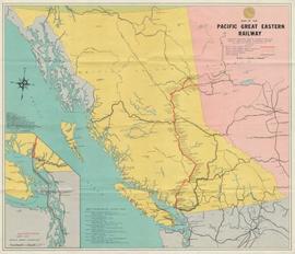
Map depicts the routes of the Pacific Great Eastern Railway, showing stations, railway connection, and the PGE Microwave Communication System.
Series consists of large format maps and plans relating to railways in British Columbia and Canada. Also includes oversize documents.
Map depicts the Shuswap Lakes, Rogers Pass, Kamloops, Yellowhead Pass, Thompson Valley, and the Nicola Valley. Also includes the first clues to a treasure hunt.
Map depicts the growth of Vancouver's street car system as from the laying of the first tracks in 1889 to the last section laid (Clark Dr., Hastings to Venables).
Map depicts rail trackage in the Greater Vancouver area, showing dates of completion and abandonment of railway lines. Also shows proposed rail lines.
Map depicts railway lines in the state of Washington, including those crossing over the border into British Columbia.
Map depicts all current rail lines in Western Canada and Alaska and major railway stations. Includes insets for Alaska & Yukon, Edmonton area, Winnipeg area, and the Vancouver area.
Hand drawn draft map depicts historical railway routes in British Columbia. Includes dates and annotated information about rail lines.
Map depicts south eastern British Columbia, with highlighted annotations by Davies to emphasize location of rail lines.
Map depicts the City of Squamish, Howe Sound, and the Britannia Mine.
Map depicts the cities of Summerland, Penticton, and Naramata. Annotated by Davies to emphasize the rail lines in the area.
Map depicts the cities of Summerland, Penticton, and Naramata. Annotated by Davies to emphasize the rail lines in the area.
Map depicts location of treasure hidden between Clearwater and Clemina, BC.
Tourist map of Prince George depicts city area, including railway trackage.
Map depicts the province of British Columbia. Includes rail lines and historical notes about the province.
Tourist map of Prince George depicts city area, with annotations by Davies to emphasize locations of rail lines.
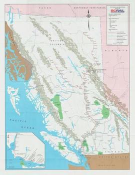
Map depicts the route of BC Rail and its connecting rail lines.
Map depicts the city of Richmond and Lulu Island, including rail trackage.
Map depicts the area around Wilkinson Creek near Carmi, BC. Annotated by Davies to show the Kettle Valley Railway.


