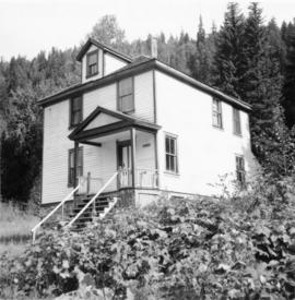
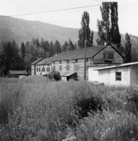
Photograph depicts one of the surviving houses on Beach Ave, Vancouver, between Gilford and Chilco.
Photograph depicts the only surviving building in the ghost town of Gerard. Its survival was due to the ownership and periodic use of the B.C. Government Fisheries Department.
Photograph depicts a swimming pool at Second Beach in Stanley Park, Vancouver, B.C. The snow in the foreground is 16 inches deep and there is a gathering snowstorm in the background coming in from the west.
Photograph depicts the CPR swing bridge crossing the Harrison River at Harrison Mills. It is a plate girder bridge carrying a double track. The bridge tender occupied a shanty at the east end of the bridge at mile 68.3 from North Bend. The timetable states that trains may proceed at restricted speed after stopping, if the tender fails to appear after 4 whistle signals and the hone signals show stop.
Photograph depicts the swing span of the road and rail bridge at Mission City, looking upstream from the south bank.
Photograph depicts switcher #8106 that served the 3 mile branch to a pulp mill. The switcher pulled with heavy string of loaded cars from the mill. The trip was a caboose run. Locomotive built in 1958 as part of a batch of 31. 17 of them remained in 1997.
Photograph depicts switcher #8106 and caboose #434612 that just arrived with a loaded train from a pulp mill. To the left lay the main track to Nelson.
Photograph depicts a switching locomotive and stand-in locomotive.
Photograph depicts an old tank car owned by a logging railway on Vancouver Island, parked at the end of a spur behind a locomotive shed of the Alberni Pacific Railway.
Photograph depicts a new tank car for sodium chlorate CN/CP interchange.
Photograph depicts a tank that was found outside of the headquarters of the British Columbia Armoured Regiment in Vancouver.
Photograph depicts a tank 'Scale Test Car' at the Kamloops CPR yard.
Photograph depicts an old tannery that appeared to be being slowly renovated after years of disuse.
Photograph depicts a telegraph line on the Williams Lake to Bella Coola road.
Photograph depicts telephone fittings on Vancouver Island.
Photograph depicts a telephone pole near Reiswig, on the main road between Vernon and Arrow Lakes.
Photograph depicts ten ballast cars of the B.C. Electric Railway on newly laid industrial spur on the northeast side of the Langley depot.
Photograph depicts the Pacific Terminus of the Trans Canada Highway in Tofino, B.C. on Vancouver Island.
Map depicts location of treasure hidden between Clearwater and Clemina, BC.
Photograph depicts the Canadian Bank of Commerce in Ladysmith, B.C. on Vancouver Island. Building is estimated to be built between 1901-1905.
Postcard depicts the Canadian Pacific Railway line where the Great Divide between BC and Alberta.
Photograph depicts the "Princess of Vancouver" loading at 7 p.m. in Vancouver.
Map depicts the route of BC Rail and its connecting rail lines.
Photograph depicts the split of the Great Northern Railway (GNR) (shown) and the Canadian National Railway (CN) tracks, immediately south of the Fraser crossing at New Westminster.
Photograph depicts the building for the Vancouver Supply Company located at 25 Alexander St. in Vancouver, B.C. It is at the center of the old downtown and may have been a former fire hall.
Photograph depicts CN track 1 mile east of Walhachin. Looking east. Thompson River running downstream, towards the camera. CPR also goes through Walhachin.
Photograph depicts CN track 1 mile east of Walhachin. Looking east. Thompson River running downstream, towards the camera.
Photograph depicts three B.C. Electric Railway locomotives on running line to the west of car barn at New Westminster.
Photograph depicts three crossing at Second Narrows in Vancouver Harbour. On the left was a new CNR bridge being built. In the middle was exsiting CN track. To the right a high level road bridge is visible.
Photograph depicts what was at one time a passing point, spur, etc. Now, it was only a 'through' track. Disappeared siding held storage for 44 cars.
Photograph depicts Tilbury dock on the Delta shore of the Fraser River. The stern of the Canadian National Railway (CN) onboard railcar carrier SS "Canora" is about 10ft away, and showing tidal and moving a piece of dock leading to shore.
Photograph depicts the view of the Tilbury rail terminal on the south bank of the south arm of the Fraser River, 1 1/2 miles east of Deer Island Tunnel. S.S. Canora is also in the picture.
Photograph depicts the Tofino Airport. It was a former wartime RCAF base built in 1942 for anti-Japanese air patrols. It was now a D.O.T controlled airport.
Photograph depicts Tofino on Vancouver Island. View taken from wharf with a lifeboat on slip.
Photograph depicts a tool house on a CNR curve in Armstrong. Not in frequent use.
Photograph depicts a disused tool house in Wasa, at the CPR Windermere Subdivision. Davies notes the structure was rarely seen at the time the photograph was taken.
Photograph depicts a tool house in Wasa, at the CPR Windermere Subdivision. Before 1970, the station had siding for 37 cars. Now it had two sidings for a total of 150 cars. Note the old box car with old lettering that was presumably on non-reserve service.
Photograph depicts a totem pole in its final stages of being carved.
Photograph depicts a tower controlling the C.P.R. grade crossing at Alexander St. in Vancouver, B.C.
Photograph taken about 2 miles west of Princeton. Depicts track beside the Tulameen River. Taken, looking west, form a ridge holding on the Princeton to Hope highway.
Photograph depicts a track car model (in fact, the base to the lamp shade).
Photograph depicts a CN Track Geometry 'Test" car for Western Canada. Built in 1954 as "Cape Race." In 1983 it was a VIA sleeper/buffet/lounge.
Photograph depicts a track shed about 1 mile south of Beaverdell or at about mile 43.25 on the CPR line in the Carmi Subdivision. Despite the open doors and ease of access, it was the only hut on the line found to contain track materials and correspondence. It retained 50 memos addressed to the Section Foreman [at Beaverdell?].
Photograph depicts the track transfer transporter at the Canadian National Railway (CN) repair shops at Port Mann.
Photograph depicts the track transfer transporter at the Canadian National Railway (CN) repair shops at Port Mann, showing the east face of the main building.
Photograph depicts trackage near the CPR depot in Salmon Arm.