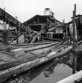
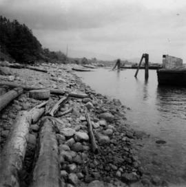
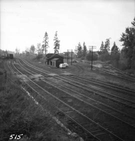
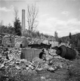
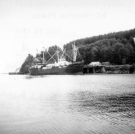
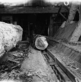
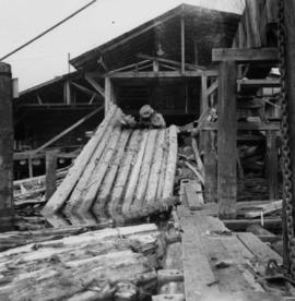
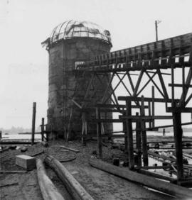
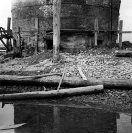
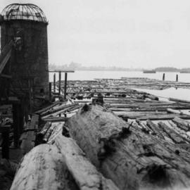
Photograph depicts a view of the booming ground of the Horne Bros. Shingle Co. Ltd. On #305 West Esplanade Rd. in North Vancouver.
Photograph depicts a view of the main saw and bull chain of the Horne Bros. Ltd. Shingle mill on #305 West Esplanade Rd. in North Vancouver.
Photograph depicts the bull chain skid at the Horne Bros. Ltd. Shingle mill on #305 West Esplanade St. in North Vancouver.
Photograph depicts an abandoned brick burner now used to take excess steam blowing off from the wood fired double boiler. The burner is at the Horne Bros. Ltd. Shingle mill on #305 West Esplanade Rd. in North Vancouver.
Photograph depicts an unused brick burner, surrounded at high tide by sea water. The burner is at the Horne Bros Ltd. Shingle mill on #305 West Esplanade Rd. in North Vancouver.
Photograph depicts a general view of the Horne Bros. shingle mill on #305 West Esplanade Rd. in North Vancouver.
Photograph depicts a ship at Schwartz Bay on Vancouver Island. The ship's name begins with the "Queen of".
Photograph depicts a ship the "Laurier", which may have been a Fisheries Protection Vessel, at the Federal Immigration Dock in Vancouver.
Photograph depicts a ship named "Pacific Northwest", possibly docked in either English Bay or Howe Sound.
Photograph depicts the ship the "Princess Louise" at Lynn Terminals in Vancouver Harbour.
Photograph depicts the ship the "Princess Louise" prior to departure at Lynn Terminals, North Vancouver. She had been tied to this wharf for at least 18 months.
Photograph depicts the ship the "Princess Louise" at Lynn Terminals in Vancouver Harbour before departure for California. It has one poorly applied coat of white paint. The anchors have been removed and the towing tackle placed in position.
Photograph depicts the ship the "Princess Louise" under tow at about 7:30 pm, passing Brockton Point in Vancouver Harbour.
Photograph depicts the ship the "Princess Louise" under tow and just passed under the Lions Gate Bridge in Vancouver.
Photograph depicts the ship the "Princess Louise" under tow by the Vancouver tug "la Pointe", just west of the First Narrows.
Photograph depicts the ship the "Princess Louise" under tow by the Vancouver tug "La Pointe", going through the First Narrows. Just before going through the current took her at 45 degrees to the course and for a moment it looked as if she might run aground.
Photograph depicts the ship the "Princess of Vancouver" emerging westwards from the First Narrows in Vancouver.
Photograph depicts the ship the "Princess of Vancouver" passing Lions Gate Bridge in Vancouver, outward bound.
Photograph depicts the ship the "Princess of Vancouver" outward bound at midday. It is passing below the Lions Gate Bridge in Vancouver.
Photograph depicts a shop on the north side of Main St. in Cumberland on Vancouver, Island.
Photograph depicts a the shoreline of Vancouver Harbour, looking east from the property line of the Burrard Grain Elevator, 375 Low Level Rd, North Vancouver.
Photograph depicts what Davies noted to be a rare sight, short lengths of rail.
Photograph depicts a derelict shovel beside the coaling wharves at Union Bay.
Photograph depicts a demonstration of an iron tire being shrunk on a wooden wagon wheel. For the benefit of the Lieutenant Governor of B.C., Walter Owens.
Photograph depicts a sign reading "Penticton East" beside a hut in the Penticton CPR depot yard.
Photograph depicts "The Mall" at Simon Fraser University.
Photograph depicts Simon Fraser University in Burnaby, B.C., 1 week after the official opening.
Photograph depicts Simon Fraser University in Burnaby, B.C., one week after the official opening.
Photograph depicts Simon Fraser University in Burnaby, B.C. The view is looking northeast towards the northwest corner of the Academic Quadrangle.
Photograph depicts Simon Fraser University in Burnaby, B.C. The view is looking northwest from the science complex towards the gymnasium.
Photograph depicts Simon Fraser University in Burnaby, B.C. The view is looking southwest from the mall towards the gym and sports arena.
Photograph depicts Simon Fraser University in Burnaby, B.C. The view is looking east towards the nearly completed water tower from the west inner face of the Academic Quadrangle.
Photograph depicts Sirdar station belonging to the C.P.R. It is at the south end of Kootenay Lake and 11 miles north of Creston. There is a little used turntable behind the depot. The view is looking south.
Photograph taken at the Northwood Pulp and Timber Ltd, Prince George. Visible is a General Motors switcher, built in 1959. Aqcuired in 1981. Its sister locomotive had just returned from some major servicing at CN shops in P.G. Built in 1954 and acquired in 1989. Would not be used until business picked up. Pulp trade in world doldrums at the time the photograph was taken.
Photograph depicts the site of the first tramway in BC that ran between Anderson Lake and Seton Lake for 1 1/4 miles and was built in 1861. It lasted for 2 years and used wooden rails. The visible piece of track bed was 70 paces southwest of the PGE depot in Seton Portage. Parts of it had been obliterated by bulldozing that took place in the centre of the village.
Photograph depicts the site of the first tramway in B.C., that ran between Anderson Lake and Seton Lake for 1 1/4 miles and was built in 1861. It is located 70 paces southwest of what is now the PGE Seton Portage depot. It was opened for trafic in July 1861 and had lasted for two years.
Photograph depicts the site of a former copper shelter, owned by B.C. Copper Co, of New York, at Anadconda, on the outskirts of Greenwood. It operated from 1901-1918. In 1899, a railway connected the mine and smelter, but no railway connected Greenwood to Nelson until 1901.
Photograph depicts the site of a former C.P.R. connection between the mainline into Vancouver and False Creek yards at West Pender St. In Vancouver. The rails are not used but still appear in the street and on the parking lot on the far side. Another parallel set of tracks 30 yards to the east are in daily use.
Photograph depicts the site of the former Marpole inter-urban depot, looking east.
Photograph depicts the site of former single tram tracks going east up Frances St., near Commercial Dr., in east Vancouver, BC
Photograph depicts the site of the station yard at the CPR Okanagan Landing (defunct 1892-1940). Visible is a surviving non-powered capstan.
Photograph depicts the site of the Coquihalla Summit depot (3,656 ft.) on the ex CPR Coquihalla Line of the Kettle Valley Railway. The only existing building of any size on the whole line(50 miles), also appears in this photo. The steel laid from the north to this point was laid in 1913/1914 and connected to Hope in 1916, The rails service was discontinued in November 1959 and the track lifted in 1962. The line climbs 36.3 miles from Hope at an average grade of 1 in 55.
Photograph depicts the site of two derailment mishaps in 1991 and 1995. In November 1991, there was (and still is) a pipe yard of West Coast Gad Transmission Ltd. located above the track. Two huge pipes got away and rolled down the cut into the path of oncoming train. A concrete block wall was erected to stop this. Also, all pipes were stored at 90 degrees to the rail track.
Photograph depicts six hydrants at Maderia Park, Sechelt. They are all marked with "T.C.I.W" for the Terminal City Iron Works, in Vancouver, BC
Photograph depicts "Six Mile House Stable" on the west side of Okanagan Lake.
Photograph depicts cargo of the Skeena Forest Products Ltd. Company. Image captured at the CNR Skeena Subdivision on the western outskirts of Terrace. Sidings here were capable of holding 27-38 cars.
Photograph depicts "Skeena Prince." The iron chute projecting from the land beyond the steam of a coaster belongs to a long defunct coal mine which ran back horizontally into the hill side.
Photograph depicts the construction of a new Sky Train station.