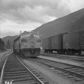
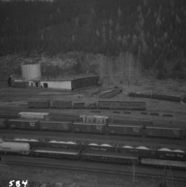
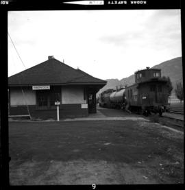
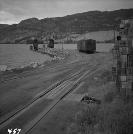
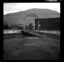
Photograph depicts the CPR turntable beside the roundhouse at Revelstoke. The view is looking east.
Photograph depicts a CPR tug named the "Okanagan" that was assembled at the Okanagan landing. It usually tooks 3 hours and 10-15 minutes to travel from Kelowna to Penticton with one rail scow in tow.
Photograph depicts a CPR tug called the"Okanagan," at the CPR slip in Kelowna. It had recently been fueled from a tank car that is visible on the left. It was was built in Seattle and assembled at Okanagan Landing.
Photograph depicts a CPR tug called the "Okanagan," located at the Kelowna slip. It was tied to the rail barge wih a steam up.
Photograph depicts a C.P.R. (Esquimalt and Nanaimo Railway) trestle bridge with a steel center span, crossing one of the numerous creeks between Mud Bay and Courtenay on Vancouver Island.
Photograph depicts a C.P.R. train switching at Osoyoos, B.C.
Photograph depicts the C.P.R. train station at Kaslo. At one time the line ran between Kaslo and Nakusp, via New Denver. It was lifted in 1915-1920. The trackage now consists of Kootenay Lake slip and about 1 mile of sidings. It is used mainly for oil (incoming) and lumber (outgoing).
Photograph depicts a C.P.R. Canadian train about to pass through the washer at False Creek yards in Vancouver, B.C.
Photograph depicts the CPR trackage north of McCulloch depot. The west track is passing, the mid is mainline, and the east track is storage. The depot is located at mile 76.6 on the Carmi Subdivision, about 27 miles northeast of Penticton.
Photograph depicts CPR trackage about 1 mile south of McCulloch depot and at about mile 75.5, on the Carmi Subdivision. At the right of the line is evidence of an old spur and log dump [from?] at least 1930-1940s. The view is looking south or downgrade, and the elevation here is about 4100 ft.
Photograph depicts the CPR trackage north of McCulloch depot. The depot was located at mile 76.6 on the Carmi Subdivision. This is at about the summit of the whole subdivision.
Photograph depicts CPR trackage at approximately mile 75.5 or about 1 mile south of McCulloch depot. This section is in the Carmi Subdivision and about 17 miles southeast of Kelowna. The dressed granite blocks are believed to be the remains of a "whistle" sign for a crossing, but the blocks are alien to this area.
Photograph depicts C.P.R. trackage at Naramata, B.C. on the east side of Okanagan Lake and 11 miles north of Penticton. This is an isolated piece of trackage about 250 yards in length, served by scows, with a quite involved layout. The refrigerated box car was built in 1950.
Photograph depicts a C.P.R. three locomotive unit approaching the south end of the yard at North Bend in the Fraser Canyon. The view is looking south.
Photograph depicts a terminus of the Slocan Subdivision. The branch is 31 mile long. Various fitments were thrown on the beach of Slocan Lake near where the barge apron touches land.
Photograph depicts the terminal of Slocan Subdivision at Mile 31.3. The old station is lettered "Mayook" and was used as a train crew shed.
Photograph depicts the C.P.R. terminal in Vancouver. A C.P.R. switcher is collecting cars from the "Princess of Vancouver" at about 7 p.m.
Photograph depicts CPR tender #415819 at Revelstoke. A painted notice had a date 1956 but otherwise there was no info as to its origins. The use is unknown.
Photograph depicts a tank car being pumped on the north side of the main line track, about 1/4 mile west of the Salmon Arm CPR depot. The view is looking east.
Phoyo depicts a CPR swing bridge in Sicamous.
Photograph depicts a CPR bridge over Pitt River.
Photograph depicts the C.P.R. summit of the southern transcontinental C.P. line at Crowsnest Pass on the Alberta-B.C. border. The roundhouse is disused. Four men are working on the turntable; it is unclear whether they are rebuilding its eastern face or demolishing it by breaking down one wall to get at the table. The site is 4,453 ft. above sea level and the view is looking south.
Photograph depicts a southbound C.P.R. streamliner at the Mud Bay crossing on Vancouver Island. This part of track belongs to the Esquimalt and Nanaimo Railway, and the crossing is being re-sited.
Photograph depicts a CPR storehouse at Mission City. It was marked as "Petroleum Store" but in fact was holding speeders and miscellaneous track equipment. It was sited on the north side of the track at the extreme east end of the depot platform.
Photograph depicts the crumbling CPR stock yard at Lytton in the Fraser Valley.
Photograph depicts a C.P.R. steam driven tracked crane at Revelstoke, BCIt was only marked "C.P. Service E.I."
Photograph depicts the C.P.R. station at Merritt, halfway between Spences Bridge and Brockmere Junction. The line is in active use.
Photograph depicts the C.P.R. station in Abbotsford, looking south.
Photograph depicts the C.P.R. station at North Bend, B.C., from a view looking north.
Photograph depicts the C.P.R. station at Kaslo on Kootenay Lake and the beginning of the steep grade of the former Kaslo-New Denver Railway. The line on the left leads to the Kaslo depot and ferry slip, and that on the right goes another 200 yards to an oil depot. All trains did and do a reverse at the foot of grade at the left behind the photo.
Photograph depicts the C.P.R. station at Invermere on the Golden-Cranbrook line, looking southwards. It is called the "Lake Windermere Station" built in 1916 of logs. The last mixed passenger train ran in 1962.
Photograph depicts the C.P.R. station at Invermere in the Kootenays. There is a trolley off the track on the road and the way freight switching at the station. Golden is to the left, Cranbrook is to the right, and the station building is at the immediate left.
Photograph depicts the C.P.R. station at Golden, B.C. The view is looking east.
Photograph depicts the CPR Osoyoos station and the arrival of the daily (except Sunday) way freight train from Penticton. The depot is at about mile 36.1.
Photograph depicts a branch that runs from Rosebury barge slip near Slocan Lake to Nakusp. A rare sight as a section of a man's house is still occupied, but whether or not by a railroader or not. This remains unknown. Trackage is used once a week by very small freight.
Photograph depicts a branch that runs from Slocan Lake to Nakusp. "L.H." track leads to barge slip on lake. "R.H." track is the "main line" to Nakusp. It is used once a week by freight that is restricted to 6 or 8 cars.
Photograph depicts a CPR spur leading to a lane on the east of Richards St in the 1300 block. Much of the trackage here is dated 1911 and may be original. The photo was taken approximately 100 yards southwest of Richards St. and Pacific St. in Vancouver.
Photograph depicts a CPR spur leading into a lumber reload facility in Campbell Creek, east of Kamloops.
Photograph depicts the site of a new CPR spur that was to be laid on a recently built rail ferry slip between Pier A3 and the old CPR Pier A.
Photograph taken at the Agassiz Musuem which was found in an old railway station, which was relocated. Captured is the front view of a CPR speeder.
Photograph taken at the Agassiz Musuem. The rear view of a CPR speeder is visible.
Photograph depicts CPR snowplow #400885 at Cranbrook. The snowplow was built in Mar. 1917.
Photograph depicts a CPR snow plows in Revelstoke placed on track that was believed to be the branchline to Arrowhead.
Photograph taken opposite the CPR depot in downtown Kamloops. Snow plow built in 1921. Spreader dated 1959.
Photograph depicts a CPR snow plow, built in 1921, and a Jordan spreader, dated 1959. Both found opposite the Kamloops CPR depot.
Photograph depictsa CPR snow plow, built in 1912.
Photograph depicts a snow plow in Cranbrook.
Photograph depicts a CPR snow plow, built in 1921 at Angus Shops in Montreal. Also visible is a spreader-ditcher, buil by O.F. Jordan Co. in 1959. Spotted at the Kamloops depot.
Photograph depicts a CPR snow plow in Revelstoke.