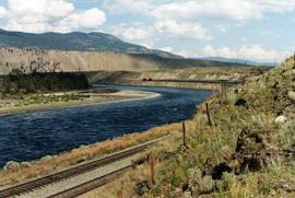
Postcard depicts "The Loop," CPR, Selkirk Mountain.
Postcard depicts "The Loop," Glacier, BC
Map depicts the province of British Columbia. Includes rail lines and historical notes about the province.
File consists of material regarding the movie, "The National Dream: Building the Impossible Railway", which was a CBC TV series based on Pierre Berton's books "The National Dream" and "The Last Spike". Predominantly consists of pamphlets, news releases, and clippings from periodicals.
Tourist map of Prince George depicts city area, with annotations by Davies to emphasize locations of rail lines.
File consists of the 1981 first edition of "The Pictorial History of Railroading in British Columbia" by Barrie Sanford.
Photograph depicts the "Princess of Vancouver" loading at 7 p.m. in Vancouver.
File consists of a monograph by Geoffrey W. Taylor entitled "The Railway Contractors".
File consists of a photocopied 1938 work by A. McCulloch entitled "The Railway Development in Southern British Columbia from 1890 on, and, Some Reasons for Building the Kettle Valley Railway, and the lines of the Vancouver, Victoria and Eastern Railway and Navigation Company in British Columbia".
File consists of issue number 436 of "Canadian Rail", which has been pared down to the feature article "The Railway History of Kamloops, B.C.: A Century Old Story" by Davies.
File consists of issues of "The Sandhouse", the journal of the Canadian Railroad Historical Association Pacific Coast Division. Contains various complete issues relating to multiple railway subjects. Also includes miscellaneous excerpted articles from Sandhouse issues.
Map depicts the route of BC Rail and its connecting rail lines.
File consists of a publication by Eric L. Johnson entitled "The Sea-to-Sky Gold Rush Route: A Guide to the Scenic Railway of the White Pass".
File consists of a book by Robert D. Turner and David S. Wilkie entitled "The Skyline Limited: The Kaslo and Slocan Railway--Narrow Gauge Railroading and Sternwheelers in the Kootenays".
Postcard depicts a spiral tunnel near Field B.C. Mount Stephen visible.
Postcard depicts 'The Spiral Tunnels."
File consists of a book by Graeme Pole entitled "The Spiral Tunnels and the Big Hill: A Canadian Railway Adventure".
Postcard depicts spiral tunnels near Yoho National Park, BC
Photograph depicts the split of the Great Northern Railway (GNR) (shown) and the Canadian National Railway (CN) tracks, immediately south of the Fraser crossing at New Westminster.
File consists of a publication by Henry Ewert entitled "The Story of the B.C. Electric Railway Company".
Postcard depicts the town of Field and Mt. Stephen. Near Yoho National Park in the Canadian Rockies.
Postcard depicts the Van Horne Range, looking west from Field, BC
Photograph depicts the building for the Vancouver Supply Company located at 25 Alexander St. in Vancouver, B.C. It is at the center of the old downtown and may have been a former fire hall.
File consists of a publication by Darryl E. Muralt entitled "The Victoria and Sidney Railway, 1892-1919".
Postcard depicts the west portal of the Connaught Tunnel, near Glacier, BCDavies noted the ventilation engine house above the entrance.
File consists of a publication by Stan Cohen entitled "The White Pass and Yukon Route: A Pictorial History"
File consists of a publication by Graham Wilson entitled "The White Pass and Yukon Route Railway".
File consists of a 1977 publication by Steve Hauff and Jim Gertz entitled "The Willamette Locomotive".
Postcard depicts a "Spectacular sight to be seen while travelling through this Canyon. Many trains rumble past with heavy loads making a grand sight when they twist and turn around corners along the clear blue water of the Thompson River."
Photograph depicts CN track 1 mile east of Walhachin. Looking east. Thompson River running downstream, towards the camera. CPR also goes through Walhachin.
Photograph depicts CN track 1 mile east of Walhachin. Looking east. Thompson River running downstream, towards the camera.
Photograph depicts three B.C. Electric Railway locomotives on running line to the west of car barn at New Westminster.
Photograph depicts three crossing at Second Narrows in Vancouver Harbour. On the left was a new CNR bridge being built. In the middle was exsiting CN track. To the right a high level road bridge is visible.
File consists of material regarding the Three Valley Gap roundhouse and heritage ghost town. Predominantly consists of photocopy reproductions, pamphlets, and clippings from periodicals.
Postcard depicts the passage through the shoulder of Mt. Stephen.
Photograph depicts what was at one time a passing point, spur, etc. Now, it was only a 'through' track. Disappeared siding held storage for 44 cars.
File consists of research material regarding rail ties, which predominantly consist of photocopy reproductions, excerpts from books, and clippings from periodicals. Includes information on date nails, wood ties, disposal of creosote ties, concrete ties, and steel ties.
Photograph depicts Tilbury dock on the Delta shore of the Fraser River. The stern of the Canadian National Railway (CN) onboard railcar carrier SS "Canora" is about 10ft away, and showing tidal and moving a piece of dock leading to shore.
Photograph depicts the view of the Tilbury rail terminal on the south bank of the south arm of the Fraser River, 1 1/2 miles east of Deer Island Tunnel. S.S. Canora is also in the picture.
File consists of a BC Railway Historical Association publication by David M. Rees-Thomas entitled "Timber Down the Capilano: A History of the Capilano Timber Company on Vancouver's North Shore".
File consists of background material on railway employee timetables.
Photograph depicts the Tofino Airport. It was a former wartime RCAF base built in 1942 for anti-Japanese air patrols. It was now a D.O.T controlled airport.
Photograph depicts Tofino on Vancouver Island. View taken from wharf with a lifeboat on slip.
Photograph depicts a tool house on a CNR curve in Armstrong. Not in frequent use.
Photograph depicts a disused tool house in Wasa, at the CPR Windermere Subdivision. Davies notes the structure was rarely seen at the time the photograph was taken.
Photograph depicts a tool house in Wasa, at the CPR Windermere Subdivision. Before 1970, the station had siding for 37 cars. Now it had two sidings for a total of 150 cars. Note the old box car with old lettering that was presumably on non-reserve service.
Photograph depicts a totem pole in its final stages of being carved.
Postcard depicts totem poles at Wapla Lake Camp. The lake was the headwaters of the Kicking Horse River.
Series consists of material regarding rail-related tourism and preservation in British Columbia. Includes information about rail tours (such as the Rocky Mountaineer and the Royal Hudson), preserved locomotives and rolling stock, the EXPO 86 transportation theme, railway museums, and heritage railways (such and the Kamloops Heritage Railway and the Kettle Valley Railway).