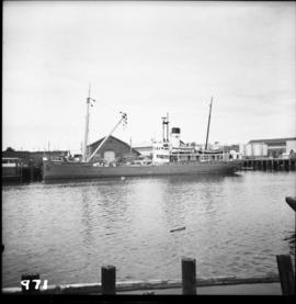
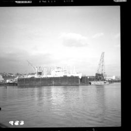
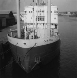
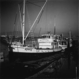
Photograph depicts a Canadian Coastguard vessel called "Camsell" at the Canadian Coastgaurd wharf in Upper Harbour, Victoria.
Photograph depicts the Canadian Coast Guard ship "Estevan" in the Upper Harbour at Victoria.
Photograph depicts the Canadian Coast Guard ship "Camsell" in Upper Harbour, Victoria.
Photograph depicts the Canadian Coast Guard rescue launch "Moorhen" or "Mallard."
Photograph taken at the Campbell Creek Industrial Park in Kamloops. Depicts the CNR end of head shunt. The connection with the Okanagan Branch is found in the middle distance.
Photograph taken at the Campbell Creek Industrial Park in Kamloops. Visible CNR track was to be inactive by August 1998.
Photograph depicts the Cameron Lake station on the Alberni branch of the Esquimalt and Nanaimo Railway on Vancouver Island. It is no longer used but has been converted to a lodge. The view is looking west.
Photograph depicts the Cambie St. Bridge in Vancouver, BC, looking east and showing the north fixed span of the bridge.
Photograph depicts the Cambie St. Bridge in Vancouver, BC, showing the west side and view facing south.
Photograph depicts the Cambie St. Bridge in Vancouver, BC, looking east and showing the central swing span.
Photograph depicts the Cambie St. Bridge in Vancouver, BC, looking southeast and showing the southern fixed span on the bridge.
Postcard depicts a cairn "marking the spot where Canadian Pacific Railway was completed on November 7th, 1885. Twenty-eight miles west of Revelstoke, BC"
Photograph depicts Cadero St. in the west end of Vancouver, looking north from Barclay St. intersection in the 800 block.
Photograph depicts a home made field cattle fodder trough found at Dot Ranch, some 200 yards from a CPR Dot spur.
Photograph depicts a line of CPR cabooses and work cars at Nelson. The foremost is #437374 and was built in September, 1948.
File consists of documentary photographs taken by David Davies of miscellaneous cabooses in British Columbia.
Photograph depicts a caboose used as a mobile "Maintenance of Way" office. It was a transfer yard caboose built in Montreal in 1977-8. Made into a series of which all except two had been put to other uses since 1991-2.
Photograph depicts a wooden-sided caboose, CPR #43708, arch bar trucks. It was built in September 1943 and may have been part of a wreck train.
Photograph depicts CPR caboose #400572 at Cranbrook. It is an older style caboose with older style lettering.
Photograph depicts a caboose that was formerly part of KVR and was on its way to Grand Forks. It now only went 3 miles to the Canadian Cellulose pulp mill in Kraft.
Photograph depicts the end view of a cable/hose car.
Photograph depicts a cable/hose car (work car) that was not part of the Kamloops Auxiliary.
Photograph depicts a cabin near Williams Lake. Its interior contained two old treadle sewing machines and a chesterfield. Davies had the impression it had not been inhabited for at least a decade.
Photograph depicts a C.P.R. fire car (extender) on the Esquimalt and Nanaimo Railway at Parksville, B.C. on Vancouver Island.
Photograph depicts "Butterchurch" that was built in 1870 under the direction of Father Rondeault of the Oblate Order for missionary work among the Comiakan Natives, a tribe of about 100. It was abandoned by about 1880 because of its location. It was recently restored as a historical shrine.
Photograph depicts the business car "Van Horne" at the C.P.R. False Creek yard in Vancouver, B.C. It is not numbered.
Photograph depicts the business car "British Columbia" (ex. C.P.R.) at the C.N. station in Vancouver. It is tailing the special to Hope, on its first run since acquisition by the West Coast Railway Association.
Photograph depicts a self-propelled rail barge.
Photograph depicts the Burrard Dry Dock Co. Ltd. on the North Shore in Vancouver. There is a freighter in dock #2.
Photograph depicts boat named "Burnaco."
Photograph depicts a BN snow plow in Fruitvale.
Photograph depicts disused, but perhaps not legally abandoned, track 2 miles south of Keremeos on the old Keremeos branch. The track was broken in several places and fences were also erected across its length.
Photograph depicts a disued or abandoned track 2 miles south of Keremeos. Tracks was broken at one bridge and at least one cover was as well. Fences were erected across it.
Photograph depicts buildings of the former Vancouver-Lansdale ferry. They appeared to now be used by Kingcome Navigation Co. as well as other businesses.
Photograph depicts small buildings sited on the north side of the tracks and just west of the Mission City CPR depot. They are all in use and well cared for.
Photograph depicts a possible storage and coal shed, and toilets located on the west side of track about a quarter mile north of the McCulloch depot building. McCulloch depot is located at mile 76.6 on the Carmi Subdivision.
File consists of documentary photographs taken by David Davies of stores and service buildings in British Columbia.
File consists of documentary photographs taken by David Davies of public buildings in British Columbia.
File consists of documentary photographs taken by David Davies of log dwellings in British Columbia.
File consists of documentary photographs taken by David Davies of various houses in British Columbia.
File consists of documentary photographs taken by David Davies of hotels in British Columbia.
File consists of documentary photographs taken by David Davies of commercial and industrial buildings in British Columbia.
File consists of documentary photographs taken by David Davies of churches in British Columbia.
File consists of documentary photographs taken by David Davies of agricultural buildings in British Columbia.
File consists of documentary photographs taken by David Davies of buildings in British Columbia.
Photograph depicts the builder's plaque of the C.N.R. S.S. Canora.
Photograph depicts a southbound Budd car on Esquimalt & Nanaimo Railway (CPR) track.
Photograph depicts the Buckingham Apartments at 925 Cardero St.and Barclay St. in Vancouver, B.C.
Photograph depicts the Buckingham Apartments at 925 Cardero St. in Vancouver, B.C. after a snowfall. The view is looking south and depicts Barclay St. crossing in the foreground.
Photograph depicts a water tower maintained by volunteers. It moved to the present site from a concrete base near the KVR trackside.