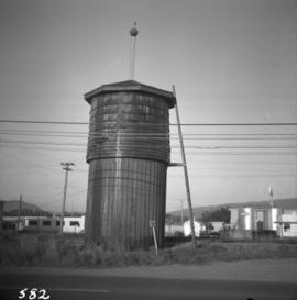
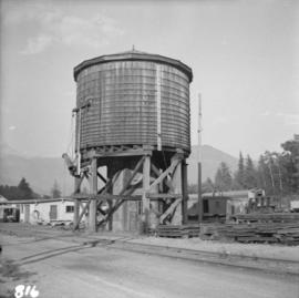
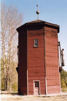
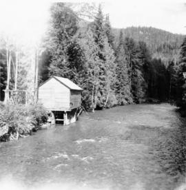
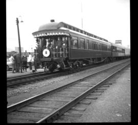
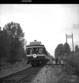
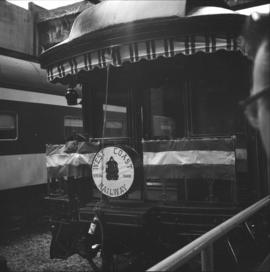
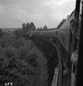
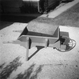
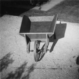
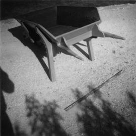
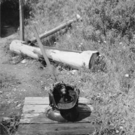
Photograph depicts a water pump, dated 1883. Animal water trough and pipe were both made out of wood, which was typical for the Barkerville period.
Photograph depicts a full but unused water tank at Duncan Station on the Esquimalt and Nanaimo Railway on Vancouver Island.
Photograph depicts a water tank at the Pacific Great Eastern yards in Brackendale, near Squamish.
Photograph depicts a static water tank, numbered 415726, at the Coquitlam C.P.R. yards.
Photograph depicts a water tank car on the CPR line at Rock Creek. Rock Creek is located at mile 11.7 from Midway and east of Osoyoos. The water tank car was built in 192, holds 8000 gallons, and forms part of a work train. The sidings capacity here is 70 cars.
Photograph depicts a preserved 2-spouted water tank. It was not on its original site.
Photograph depicts the water tower at B.C. Forest Products Ltd. Mill at Port Hammond, in the Fraser Valley.
Photograph depicts a surviving but disused water tower at Cranbrook. Cranbrook is located at mile 0 on the CPR line of the Nelson Subdivision.
Photograph depicts the water tower at the C.P.R. Savona Depot. The view is looking east towards Kamloops.
Photograph depicts an abandoned water tower on CPR line at Brookmere, 30 miles south of Merritt. The trackage on the right has had the spikes removed but the yard consists of a mixture of completely removed, partially removed, and completely undisturbed track. An elderly couple and 2 elderly bachelors are the only year-round remaining inhabitants.
Contour plan shows layout of a water tunnel near Lyon's Creek in the CNR Clearwater subdivision.
Photograph depicts a working undershot water wheel on Lardeau Creek River. It was the only water wheel seen in B.C. between 1963 and 1970. It was designed to drive an electricity generating set, but it was not coupelled to the set at the time.
Photograph depicts a weather ship of the Canadian Coastguard called "Vancouver." It was fitting out after launching. This vessel and its sister ship, "Quada," were the largest vessels ever built on the western coast of Canada. "Vancouver" was retired in May 1981 as it was too costly to service.
Photograph depicts decommissioned weather ships. One was named "Stonetown." They were formerly coastguard vessels that were in use until 1968. Prior to that, they were corvettes of the RCN and moored in Vancouver Harbour at the Terminal Pier.
Map depicts the city of Richmond and Lulu Island, including rail trackage.
Photograph depicts West Coast Electric Ltd., an electric manufacturers and shop.
Photograph depicts a train car that is part of the West Coast Railway Association special trip from Vancouver to Hope on August 8, 1964. It is stopped on the east side of Sumas Bridge.
Photograph depicts one of the two open C.P.R. cars located at Vancouver included in the West Coast Railway Association special trip from Vancouver to Hope. The cars stopped at Sumas Bridge for a photo halt.
Photograph depicts a West Coast Railway Association locomotive and car at C.N. station, ready but not permitted to steam (federal ruling).
Photograph depicts a West Coast Railway Association locomotive and car at a C.N.R. station in Vancouver. The trackage actually belongs to a demolished Great Northern Railway Station.
Photograph depicts a West Coast Railway Association 2-8-2 tank locomotive and tender at a C.N. station in Vancouver, B.C.
Photograph depicts the West Coast Railway Association on a special outing from Vancouver to Hope.
Photograph depicts the West Coast Railway Association special on the Canadian National Railway (CN) trestle, immediately south of the Fraser River bridge at New Westminster, travelling east.
Photograph depicts train cars of the West Coast Railway Association on the reversing triangle at the C.N. station in Hope. The cars are apart of the special trip from Vancouver to Hope on August 8, 1964.
Photograph depicts the west end of a passing loop in Jura. Looking east.
Photograph depicts the west end of a passing loop in Jura.
Photograph depicts the extreme west end of C.P.R. trackage at Coal Harbour, looking east towards the yards and downtown after a snowfall.
Photograph depicts a view of Vancouver's West End.
Photograph depicts the West Summerland CPR station in the Okanagan. The station often was used but not permanently manned. It was located at mile 9.5 from Penticton. The view is looking south.
Photograph depicts the West Summerland CPR station in the Okanagan, located 9.5 miles from Penticton. The cloud in the middle distance is stone dust from a crusher on the east side of the track. The spur to the right leads to an old crusher but does not appear to be used.
Photograph depicts the Westbridge CPR depot on the Kettle Valley Line. It is located about 11 miles north of Rock Creek and at about mile 123.3 east of Penticton. The depot house is disused and the sidings contained no cars, so there appears to be no local traffic.
Photograph depicts the "Westbridge II" tug at the Kingcome Navigation dock, Vancouver.
Postcard depicts the western entrance to Kicking Horse Canyon.
Photograph depicts the western portal of the C.P.R. Connaught Tunnel under Rogers Pass. The Glacier Station is a quarter mile to the rear of the camera. Fans are operated to force air through the tunnel against the direction of the trains, these therefore used for all westbound traffic. Diesel driven, steam for ancillary equipment.
Photograph depicts the Westholme post office.
Photograph taken on the CPR branch from Vernon to Lumby. Depicts a small Weyerhaeuser sawmill. Looking west at Lumby. The end of the track was another 1/3 of a mile behind the camera.
Photograph depicts a wharf at Lang Bay, 14 miles southeast of Powell River. In fair repair, now used only by an oil company to pump in oil to a storage depot behind the camera.
Photograph depicts a wharf at Sechelt village on the Sechelt Peninsula. The view is looking southeast towards Vancouver.
Photograph depicts the Wheatsheaf Inn "pub" on the way to Cedar-by-the-Sea from Nanaimo, B.C.
Photograph depicts a wheelbarrow purchased in 1969, secondhand.
Photograph depicts Wickaninnish Beach, north of Ucluelet on Vancouver Island.
Map depicts the area around Wilkinson Creek near Carmi, BC. Annotated by Davies to show the Kettle Valley Railway.