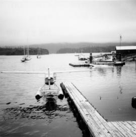
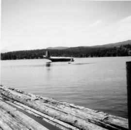
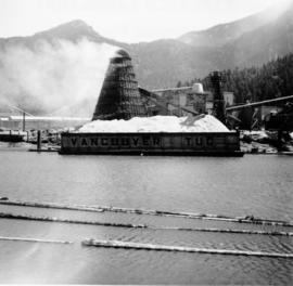
Photograph depicts one of the two Mars flying boats that were used as water bombers. Either "Hawaii Mars' or "Phillippine Mars."
Photograph depicts a "Master" tug after it underwent restoration in False Creek, Vancouver. It was under steam, and entering English Bay.
Photograph depicts the Sea Cadets Corps Amphion of Nanaimo marching in the 1970 Nanaimo May Day Parade near Comox Road. The Corps is doing a "Present Arms" and are in "Close March" formation. This is a salute, likely as they pass the parade review platform. The newly built Tally-Ho Lodge is in the background, suggesting that the Corps is marching south on Terminal Ave. at Comox Road intersection, having just crossed the Millstream Bridge. Terminal Ave. is also the official Trans-Canada Highway (1962-1971), which was still very new at this time.
Photograph depicts Mayo Lumber Co. locomotive # 3 on display at Paldy, in central Vancouver Island.
Photograph depicts Mayo Lumber Co. 2 truck Shay locomotive # 3 on display at Paldy, between Duncan and Lake Cowichan, B.C.
Photograph depicts Mayo Lumber Co. locomotive # 3 on display at Paldy, between Duncan and Lake Cowichan, B.C.
Photograph depicts Mayo Lumber Co. Shay locomotive # 3 on display at Paldy, between Duncan and Lake Cowichan, B.C.
Photograph depicts the McCulloch CPR depot located at mile 76.7 on the Carmi Subdivision, which is about 27 miles northeast of Penticton. The rear building is the passenger depot, which was painted blue inside. The view is looking north.
Photograph depicts the McCulloch CPR depot located at mile 76.7 on the Carmi Subdivision, which is about 27 miles northeast of Penticton. The building on the right is the passenger depot, which was last officially used in January 1964. The view is looking south on the downgrade.
Photograph depicts the McCulloch CPR depot located at mile 76.6 on the Carmi Subdivision., about 27 miles northeast of Penticton. The lifted switch at the right leads to a former "Y" that led east. The view is looking north.
Photograph depicts the McCulloch CPR depot at mile 76.6 on the Carmi Subdivision. The depot was painted blue inside. The last passenger train was seen 17 January 1964 and the last freight train on the 19 May 1973.
Photograph depicts a tiny switcher that belonged to the McLean sawmill and was buily by Buda of New Westminster, circa 1927. Sat on unconnected trackage adjacent to the Alberni Pacific Railway and was part of a sawmill exhibit.
Photograph depicts a meat carcass windlass.
Photograph depicts a meat hanging shed on a ranch on Granby River Road, Grand Forks.
Photograph taken in Coalmont, a ghost village that was livening up. Visible is the Meat Market store, the only surviving building on the frintage of this block, adjacent to the hotel.
Photograph depicts a mechanical side cutting machine at the C.P.R. Coquitlam yards.
File consists of a publication by Jim Hope and Donald Bain entitled "Memories of Canadian Pacific Steam Power in British Columbia".
Photograph depicts a compressed air locomotive that was built in 1901 for Michel underground coal mine work. It was removed from workings in 1965.
Photograph depicts a compressed air locomotive that was built in 1901 for Michel underground coal mine work. It was removed from workings in 1965 and was purchased by the present owner as an exhibit.
Photograph depicts the middle section of C.P.R. Pier A1 at the foot of Thurlow St., which was built in 1890. The pier is in regular use though its seaward face is in very poor shape.
Photograph depicts the Midway CPR depot located at the eastern terminus of Kettle Valley Railway. It was a subdivisional point with way freights originating at Nelson and Penticton, and running west and east respectively to Midway. There are two to 3 freights weekly from Nelson and 1 to 2 from Penticton. It lost its agency in June 1969 and all small freight [
Photograph depicts a mill and beehive burner.
Photograph taken on the CPR branch from Vernon to Lumby. Depicts a mill just west of Lumby (Possibly Lavington Planer Mills or Riverside Forest Mill). Daily way freights by CN and CP.
Photograph depicts a mine building at the copper mine in Britannia Beach. The mine was still in use and well maintained.
Photograph depicts the mine buildings of the mine at Coal Creek that closed in 1959. The newer buildings date to circa 1930. Much of the standard gauge trackage of Morrissey, Fernie, and Michel railway (subsidiary of the Great Northern Railway) in mine area remains. The track between Coal Creek and Fernie has not been lifted.
Photograph depicts a mine car at Moyie mine, at Moyie, 20 miles south of Cranbrook. The mine produced silver, zinc, and lead, and worked principally from 1900-1910. It is now disused.
Photograph depicts a narrow gauge mine locomotive built bu Hunslet Engine Company Ltd., Leeds, England in 1949. It was used by the Elk River Colliery until about 1965.
Photograph depicts a mine 200 yards south of Moyie village, which is 20 miles south of Cranbrook. It produced silver, zinc, and lead from 1900-1910 and had a smelter a quarter mile away. The shaft was 900 ft. deep, with levels going under Moyie Lake. The head gear dates from 1925-1935 and has electric winding.
Photograph depicts a mine ore car exhibited on the site of the Granby Mine at the ghost town of Phoenix, near Grand Forks.
Photograph depicts a public display erected in Slocan. Visible is a mine shaft ore hauling donkey engine of 1921.
Photograph depicts four mine sweepers crewed by officer cadets from Royal Roads that were undergoing navigational instruction. The sweepers were tied up for the night.
Photograph depicts four mine sweepers crewed by officer cadets from Royal Roads, Esquimalt.
Photograph depicts a mineral ore (lead or zinc?) mines near the ghost town of Sandon, on the road between Kaslo and New Denver.
Photograph depicts the Mission City CPR depot located at mile 87.3 from North Bend in Cascade Substation. It was built in 1902 and add onto in 1909. It has living quarters on the 2nd floor that are still in use, which is quite rare for BC in 1973.
Photograph depicts the Mission City CPR depot located at mile 87.3 from North Bend in Cascade Substation. It was built in 1902 and add onto in 1909. It has living quarters on the 2nd floor that are still in use, which is quite rare for BC in 1973. It is 41.7 miles from Vancouver and 2, 839.6 miles from Montreal.
Photograph depicts the Mission City rail and road bridge. It is owned by the CPR and was opened in 1891. It was used by road vehicles between 1 July 1927 and the 23 June 1973, using a one way flow system. On the latter day, a new high level road bridge was unofficially opened. By early July 1973, the CPR had removed the wooden deck planking.
Photograph depicts mixed freight with 5 ballast cars at the rear, running east through the former New Westminster depot, which is just to the left of the photo. The view is looking southwest.
Photograph depicts a mobile transformer of the B.C. Hydro Railway in use at the freight yard below the Georgia Viaduct.
Photograph depicts a model of a 2 man track car presented to Giovanni Marra in 1973 upon his retirement as a CPR Kamloops road master. Model made by L.G. Snowden (modeller and then locomotive engineer for CPR).
Photograph depicts a model of a Fairmont track car that was presented to Giovanni Marra in 1973 and built by L.G. Snowden.
Photograph depicts a model of a Fairmont track motor of the 1960's.
Photograph depicts a one-tenth scale model of a Fairmont track vehicle. Presented to Giovanni Marra in 1973.
Photograph depicts Moha Bridge which crosses the Yalakon River. Taken at the side of a derelict mining village.
Photograph depicts a monoplane in Tofino Harbour, near Longbeach, on Vancouver Island.
Photograph depicts the Monte Creek reaction ferry that was closed on August 6, 1972.
Photograph depicts the mooring on south side of Coal Harbour and 100 yards east of the Bayshore Hotel, looking northwest to north.
Photograph depicts the moorings in front of the Bayshore Hotel in Coal Harbour, Vancouver.
Postcard depicts Morant's Curve which was the most famous photograph location on the Canadian Pacific Railway. Here it was seeen with the Bow Range on the Continental Divide in the background.
Photograph depicts a motor trolley travelling east and dropping off ties at the Canadian National Railway (CN) track side about a half mile east of Fort Langley/