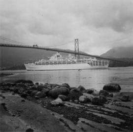
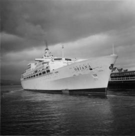
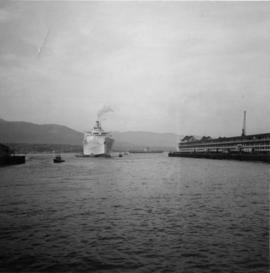
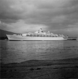
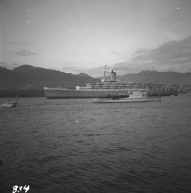
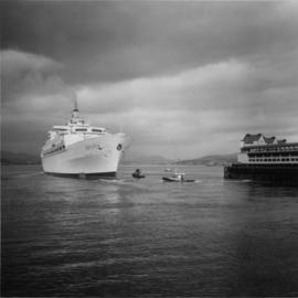
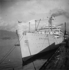
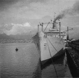
Photograph depicts a P & O liner, the "Oriana,"departing from CPR Pier C.
Photograph depicts the Orient/P & O line, the "Oriana," that was built in 1960 by Vickes Armstrong. It was turbine driven.
Photograph depicts a P & O liner, the "Oriana," backing out from CPR Pier C in Vancouver. Minor assistance was needed from two cates tugs.
Photograph depicts a liner called the "Oriana."
Photograph depicts a P & O liner, the "Oriana," passing outward bound from Vancouver between Brockton Point and the Lion's Gate Bridge. Taken from Stanley Park.
Photograph depicts a P & O liner, the "Orcades," at CPR Pier B. It was about to sail to Hawaii and New Zealand.
Photograph depicts a P & O liner, the "Orcades," at Pier B of the CPR, about to depart for direct passage from Hawaii to Sydney.
Photograph depicts an oxen powered log carrier with wheels that are approximately 10 feet in diameter. It is at Pioneer Park and Museum near Totem Lake, 3 miles north of Yahk and 30 miles east of Creston.
Photograph depicts an overbridge of the Esquimalt & Nanaimo Railway on the northern outskirts of Victoria which was at one point close to where the island highway and Colwood roads diverge.
Photograph taken on the outskirts of Merritt, looking northwest. Captured from a lumber stack and the boundary of Weyerhaeuser Lumber Co. KVR had trackage into their mill with worthwhile out-bound traffic.
Photograph depicts an outhouse on Notch Hill in the Shuswap. Helper locomotives were stationed here to lift heavy trains over Notch Hill. It was presumably used by waiting engine crews.
Photograph depicts a view looking northwest at Osoyoos Lake, B.C.
Photograph depicts an original trappers cabin on Staubert Lake.
Photograph taken looking west towards a lake. Davies notes that the reason for this visible particular configuration is that the CNR and the CPR yards used to be west of Ellis. At the time the photograph was taken, such land was needed for better development, e.g. hotels, high rise residences, sports area, etc.
Photograph depicts the Orient Line "S.S. Oronsay" leaving Vancouver Harbour.
Photograph depicts the Orient Line "Chusan" at the C.P. Pier . It is unloading cargo and taking on fuel.
Photograph depicts an ore wagon with a drop bottom device. It was drawn by horses or a steam tractor.
Postcard depicts the Thompson River, 6 miles north of Spences Bridge, on the Okanagan Trail.
Photograph taken on the shores of Wood Lake, a very picturesque stretch.
Photograph depicts a view near Nootka, looking north towards Bligh Island. Photo taken from the M.V. Uchuck III.
Photograph depicts a view of Friendly Cove, near Nootka, on the west coast of Vancouver Island. View is taken from the M.V. Uchuck III.
Postcard taken on Field Hill, along the CPR line.
Photograph depicts an old wooden lifting span bridge (now rigid) over the east Thompson River at Pritchard, 25 miles east of Kamloops. View is looking northeast. The bridge was built for sternwheeler traffic.
Photograph depicts a water wagon made in Chicago on the south side of the Westminster Highway on Lulu Island. It was 1 mile east of #6 Road. The water wagon was undated.
Photograph depicts an old wagon at a ranch on the east side of Peterson Creek.
Photograph depicts an old truck in daily use on East Hastings St. in Vancouver, BC
Photograph depicts one of the few surviving old style garages in west end Vancouver on Barclay St.
Photograph depicts an old steam boiler in the garden of a house at Fort Steele, near Cranbrook. It was last used in a pumping house half a mile away, which pumped water from a deep well to residents of the village. The pump house is still standing.
Photograph depicts an old sledge found in a field adjacent to a bridge that went over the South Thompson River.
Photograph depicts an old pelton wheel at a former quarry at Granite Falls on the northeast head of the Indian Arm.
Photograph depicts an old mine at Woodbury Creek, 10 miles south of Kaslo on the Kaslo to Nelson Road. Presumably it was a silver, lead, and zinc mine.
Photograph depicts one of various old lead and zinc mine buildings. Behind this building, on the foreshore, were a few men working on the reclamation of tailings and waste from the mine that was dumped in Kootenay Lake.
Photograph depicts old locomotives found somewhere in Washington or Oregon.
Photograph depicts an old hotel sightseeing bus built prior to 1923. It is located at the Cowichan Valley Forest Museum.
Photograph depicts one of the few surviving hand operated gas pumps, halfway between Campbell River and Kelsey Bay, BCWithin three months this gas station will have electricity.
Photograph depicts an old gas station at 1603 West 3rd Ave. and Fir St. in Vancouver, BC
Photograph depicts an old CPR passenger car at Salmon Arm. It is now in work service as #41645.
Photograph depicts old CPR passenger car at Salmon Arm. The car is now in work service as #41645 and is used for storage.
Photograph depicts an old wooden CPR caboose, formerly #436919, at Kamloops. It was built in 1928 and has sat unmoved for 2 or 3 years. By 1981 it had disappeared.
Photograph depicts old CPR boxcar #42018 at Savona, on the west end of Kamloops Lake. It was built in July 1922 and is now in work service. It has steel ends and frame but wooden sides.
Photograph depicts the end of the old Coal Harbour extension of the C.P.R. line from Vancouver. It was disused for several years. The view is looking east with Woodward's Marina behind.
Photograph depicts an old church or school being demolished at 1701-1721 West 3rd Ave. (and Pine), in Vancouver, B.C.
Photograph depicts an old business car located on a spur on the west side of the Nelson CPR depot, where it seems to be a semi-fixture. The business car was #13 and had no dates.
Photograph depicts an old building at 119 Water St. in Vancouver, B.C.
Photograph depicts a once used booming boat made of log sections at a log dump on seashore about 5 miles north of Powell River, and opposite Harwood Island. Stern at left with prop guard.
Photograph taken at Okangan Lake, on Alexis Beach. O'Keefe Ranch is located at the head of the lake. Visible is an old house that was used as a hay barn.
Photograph depicts 2 locomotives and a 2 car train, both northbound.