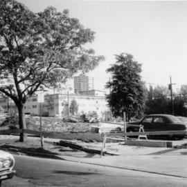
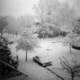
Photograph depicts the junction of Robson and Cordero St. in west end Vancouver, B.C. The photo is looking northwest on the newly demolished block, except for some houses at far end. View is looking down Robson St., with Cordero St. intersecting the photo.
Photograph depicts the joint CPR and CN depot at Vernon. The depot office had three employees working inside. Vernon is at mile 46.2 from Sicamous, on the Okanagan Subdivision of the CPR. It has daily way freight.
Photograph depicts the joint CPR and CN depot at Vernon. It shows a general view of the trackage, opposite the former depot, which is now attractively used for other purposes. The caboose on the left is CP # 437369, built in July 1949, and fairly recently painted.
Photograph depicts the joint Car and Cn depot at Vernon. The photo shows CPR caboose #437369, which was built in July 1949. It is used on a regular basis for local freights.
Photograph depicts part of the Vernon yards just south of the principal round crossing. A box car without wheels on a sunken warehouse spur is visible.
Photograph depicts a daily freight car and a few CPR locomotive switching cars.
Photograph depicts what was believed to be the engine house of a private spur belong to the former Jingle Pot Coal Mine. The turning wye was retained by the Esquimalt & Nanaimo Railway and was lcoated behind the photograph at another 150 yards of track.
Photograph depicts what was believed to be a commencement of the private line to the Jingle Pot Coal Mine that had long since been closed. At the point where the cars disappear, line diverges into a wye which meets the Esquimalt & Nanaimo Railway tracks at the Wellington depot.
Photograph depicts a two road engine house, located about 300 yards west of the Wellington flag stop on the Esquimalt & Nanaimo Railway. Visible is a house that was believed to be a part of a private railway operated by the Jingle Pot Colliery.
Photograph depicts the interior of an engine house which may have been the property of Jingle Pot Colliery. It was located 300 yards west of the Wellington flag stop of the Esquimalt & Nanaimo Railway.
Photograph depicts existing CPR trackage as well as private trackage believed to be owned by Jingle Pot Colliery.
Photograph depicts a Japanese cadet sailing ship called "Kaiuo Maru" at Centennial Pier, Vancouver. Its visit was part of 1966 Vancouver Sea Festival and the ship was open to the public for inspection.
Photograph depicts a Japanese cade training ship called "Kaiuo Maru" at Centennial Pier, Vancouver. Its visit was part of 1966 Vancouver Sea Festival and the ship was open to the public for inspection.
Photograph depicts a Japanese cadet sailing ship called "Kaiuo Maru" at Centennial Pier, Vancouver. Its visit was part of 1966 Vancouver Sea Festival and the ship was open to the public for inspection. Note the radar apparatus on the foremast.
Photograph depicts a Japanese sailing ship, "Kaiuo Maru" at Centennial Pier, Vancouver. Captures the stern view at sunset.
Photograph depicts a steam floating derrick (owned by Mckenzie Barge and Derrick Co. Ltd.) loading contariners from a scow into the hold of "Japan Line." Use of the crane on the non-deck side of a ship was unusual and the use a steam crane was quite exceptional, Davies notes.
Photograph depicts containers being hoisted onto "Japan Line" by means of a steam derrick (owned by Mckenzie Barge and Derrick Co. Ltd.) tied alongside scow holding containers. Davies notes that this was an unusual sight.
Photograph depicts "Island Tug #125," on the north arm of the Fraser River. Travelling downstrean from Patulla Bridge, New Westminster, and the CNR Lulu Island rail bridge.
Photograph depicts an island tug in Vancouver harbour.
Photograph depicts the "Island Chief" tug of the Island Tug and Barge Company, off pier A3 (CPR) in Vancouver.
Photograph depicts an iron cannon found outside the BC Regiment Armoury in Vancouver.
Photograph depicts a privately owned tug of the Interior Lake Services called "Iris G." It was used to haul rail barge #6 between Slocan and Rosebury on Lake Slocan. It was in 1956 in New Westminster.
Photograph taken at the intersection of Nelson and Denman Streets. Three quarters of the blook had just been cleared for a new high rise and shopping complex.
Photograph depicts the intersection at Cordero and Nelson St. in the west end of Vancouver. The view is looking north along Cordero St.
Photograph taken at the intersection of Cardero and Barclay Streets, looking northeast. Captured at 925 Cardero, the Buckingham Apartments.
Photograph depicts the intersection at Cordero and Barclay St. in the west end of Vancouver. The view is looking north along Cordero St.
Photograph depicts an interchange freight train making for the Pacific Great Eastern yards. It is just off the Second Narrows Bridge in Vancouver, B.C.
Photograph depicts an inscription cut into a rock face found in Bedwell Harbour. The HMS Segeria, dated 1873-1911, was the only warship in Esquimalt at Queen Victoria's death responsible for firing the death salute of 81 guns, the Queen's age. The ship also served in the Pacific as a survey vessel rom 1897-1910. After, it was sold as a Boys Naval Brigade ship in Vancouver.
Photograph depicts the inner harbour at Victoria and the C.P. ship the "Princess Patricia."
Photograph depicts the inner harbour at Victoria and the C.P. ship the "Princess Patricia" putting to sea.
Photograph depicts an industrial item atop logs and tracks.
Photograph depicts an Indian Roman Catholic church at the mouth of Anderson Lake. No services were held anymore. It was externally restored in 1968 by the white people of the village, while the Natives did the interior. Unfortunatley, there was no work done on the interior as of the date the photograph was captured.
Photograph depicts a view of Indian Arm, looking south from Granite Falls.
Photograph depicts an implement shed at Cloverdale in the Fraser Valley on the Pacific Highway.
Photograph depicts the end part of an idle car nearest to a crane boom.
Photograph depicts a hydraulic sluicing monitor that was not a piece on display in the exhibit, but was a piece of abandoned equipment found below Barkerville town. It was made by Empire Foundry, Marysville, California.
Photograph depicts an embankment across the inlet of Hydraulic Lake on the CPR line. This a the south end of the McCulloch depot and you can see the buildings in the distance. It is located at mile 76.5 on the Carmi Subdivision, about 27 miles northeast of Penticton.
Photograph depicts Hudswell Clarke 0-6-0 diesel shunter locomotive #21, owned and on the premises of Vancouver Wharves Ltd. in North Vancouver. It is having a new transmission installed and receives an annual paint job in sky blue. It has a Gardiner (Manchester) engine. Comes the plate "Samuel Williams & Sons Ltd." (of Dagenham, Essex, U.K.), which is the parent company of the V.W. Ltd.
Photograph depicts "H.R. Macmillan," a private yacht.
Photograph depicts a few houses on Beach Ave., Vancouve. They were examples of about a dozen surviving homes on Beach Ave.
Photograph taken looking northwest at a corner house and another home to its left. They were 2 of 9 houses in this Beach Block, the last block of houses on Beach Ave.
Photograph depicts a house that provided an example of the few surviving homes left on Beach Ave.
Photograph depicts a house that had just been repainted on the north side of Pender Street.
Photograph depicts a house on the east side of Ontario Street, Vancouver.
Photograph depicts a well cared for house that was empty and being stripped along with 3 other house on Barclay to make way for a high rise apartment block. Built circa 1905.
Photograph depicts a house on Nicola St. at the southwest corner of the intersection of Nicola and Robson St., in Vancouver, B.C.
Photograph depicts one of the few remaining inhabioted and well kept houses that still survived in the very heart of downtown Vancouver.
Photograph depicts a house that was probably built in 1890-1900. It had just been demolished.
Photograph depicts a house on the southern edge of Chinatown.
Photograph depicts a house that had a "sold" notice on it and was partly demolished. Up to the date the photograph was captured, this block on Beach Ave. was the sole remaining one to have only houses on it, as opposed to a mixture of houses and apartment blocks, or blocks only.