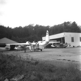
Photograph depicts a Gruman Goose of the Trans Provincial Airpline discharging passengers, having just landed on floats and then taxied on wheels up a ramp.
Photograph depicts the stern view of "Gulf Grenadier," a Canadian easr coast fishing dragger. It had not been in use for about a year.
Photograph depicts a 9 car barge called the "Gulf Railroader" and owned by the Gulf of Georgia Towing Company Ltd. It was tied to a CNR slip on Lulu Island, Richmond and was used on the northern arm of the Fraser River shuttle service. The middle car is a flat car filled with high stanchions.
Photograph depicts a 9 car barge called the "Gulf Railroader." It was used on the shuttle service on the northern arm of the Fraser River between the plywod mills in Vancouver and Brunaby as well as the CNR slip on Lulu Island, Richmond.
Photograph depicts gulls at Lost Lagoon in Vancouver, B.C.
Photograph depicts the "Haida Chieftain" tug of the Kingcome Navagation Ltd. at their wharf in Vancouver.
Photograph depicts Hamilton St. in Vancouver. The photo was taken at the back of 1250 Homer St, but is actually on Hamilton St., looking east. The left-hand line is in regular use, but the siding on the right hand side is not.
Photograph depicts Hamilton St. in Vancouver, looking northeast.
Photograph depicts the Hanceville Bridge that went over the Chilcotin River.
Photograph depicts a hand car at the Fort Steele Railway Museum. Built by Fairmont of Canada.
Photograph depicts a hand car owned by the Kettle Valley Steam Railway. Behind it was a Woodings inspection car.
Photograph depicts the hand truck and track material at Tilbury, Delta in the Fraser Valley. It belongs to the Canadian National Railway (CN)
Photograph depicts a building that was believed to have had many usess, its last being a fish store.
Photograph depicts Coal Harbour in Vancouver. The photo is facing land fill with stone on the tidal side. The site is for the first block of the Harbour Park Development Ltd. high rise apartments.
Photograph depicts the Harbour Park Development site in Coal Harbour, Vancouver. Taking rock from the scow to face fill with anti-erosion material. The site is for new high rise apartments at the edge of Stanley park between Georgia St. and the sea.
Photograph depicts a harbour seal. Davies' sailboat is in the foreground.
Photograph depicts a harbour seal diving into the water after sunning on a boom log. The bow of Davies' sailboat is in the foreground.
Photograph depicts the yard at the Hat Creek Ranch. Hat Creek used to be a staging post on the Cariboo Road.
Photograph depicts a good example of a newly made farm gate.
Photograph depicts Hat Creek Staging Hotel, 7 miles north of Cache Creek. The hotel buildig were now part of a farm and contained stores, a cookehouse, and a dormitory.
Photograph depicts a hay meadow crane located on a loop road between Ashcroft and Kamloops.
Photograph depicts Hazelton Bridge that was believed to be built in 1930. Crossing the Skeena River.
Photograph depicts the Hazelton suspension bridge.
Photograph depicts the head of Burard Inlet in Port Moody.
Photograph depicts the head of Burard Inlet in Port Moody. Looking northwest, towards a locomotive.
Photograph depicts the headquarters and general offices of the National Harbours Board in Vancouver, B.C., located at the foot of Dunlery St.
Photograph depicts the Hedley Gold Mine, 26 miles east of Princeton. Crusher workings.
Postcard depicts Hells Gate, Fraser Canyon, BC
Photograph depicts a Fairmont section gang "motor car." Property of Kamloops Heritage Railway. On display at the CNR station in downtown Kamloops.
Postcard depicts Hermit Range and Rogers' Pass, CPR.
Photograph depicts a hillside flue and a 120 ft. stock of copper smelter that operated from 1901 to 1908. The stock was built sometime between 1903-1909.
Photograph depicts a hi-rail crane that was located in the Cn Junction yards, Kamloops.
Map depicts historical rail lines in the BC lower mainland, including trackage for the BC Electric Railway, the Canadian Northern Pacific Railway, the Canadian Pacific Railway, the Great Northern Railway, and the Pacific Great Eastern Railway, among others.
Photograph depicts the H.M.C.S. Beacon Hill at English Bay in Vancouver during the maritime festival.
Photograph depicts HMCS Discovery Naval Reserve headquarters in located on Deadman's Island, Vancouver.
Photograph depicts the H.M.C.S. Mackenzie in English Bay in Vancouver during the maritime festival.
Photograph depicts the H.N.C.S. Mackenzie in English Bay in Vancouver, during the maritime festival.
Photograph depicts the H.M.C.S. Saskatchewan in English Bay, Vancouver during the maritime festival.
Photograph depicts the HMCS St. Croix that was built by Marine Industries Ltd. Of the Restigouche class and was one of the 22 Canadian destroyer escorts.
Photograph depicts a destroyer escort of the "Restigouche" class. Armament included two 3'' guns faced forward, and two sets each of 3 barelled depth charge motors.
Photograph depicts a hoist house located near an outfall to a turbine house. An operator sat in the penthouse to work the crane.
Photograph depicts Golly's Grocery that was closed and slightly vandalised.
Photograph depicts a home on 390 Franklin St., Nanaimo, B.C. on Vancouver Island.
Photograph depicts a home at 673 Selby St. in Nanaimo, B.C. on Vancouver, Island.