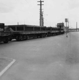
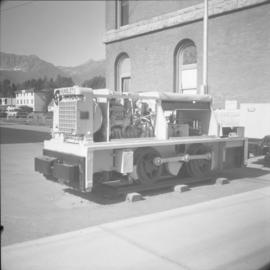
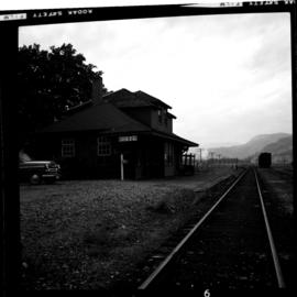
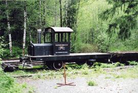
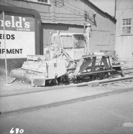
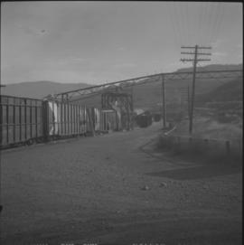
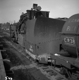
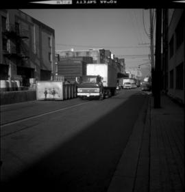
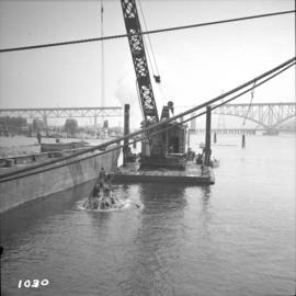
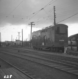
Photograph depicts a mobile transformer of the B.C. Hydro Railway in use at the freight yard below the Georgia Viaduct.
Photograph depicts mixed freight with 5 ballast cars at the rear, running east through the former New Westminster depot, which is just to the left of the photo. The view is looking southwest.
Photograph depicts the Mission City rail and road bridge. It is owned by the CPR and was opened in 1891. It was used by road vehicles between 1 July 1927 and the 23 June 1973, using a one way flow system. On the latter day, a new high level road bridge was unofficially opened. By early July 1973, the CPR had removed the wooden deck planking.
Photograph depicts the Mission City CPR depot located at mile 87.3 from North Bend in Cascade Substation. It was built in 1902 and add onto in 1909. It has living quarters on the 2nd floor that are still in use, which is quite rare for BC in 1973.
Photograph depicts the Mission City CPR depot located at mile 87.3 from North Bend in Cascade Substation. It was built in 1902 and add onto in 1909. It has living quarters on the 2nd floor that are still in use, which is quite rare for BC in 1973. It is 41.7 miles from Vancouver and 2, 839.6 miles from Montreal.
Photograph depicts four mine sweepers crewed by officer cadets from Royal Roads that were undergoing navigational instruction. The sweepers were tied up for the night.
Photograph depicts four mine sweepers crewed by officer cadets from Royal Roads, Esquimalt.
Photograph depicts a narrow gauge mine locomotive built bu Hunslet Engine Company Ltd., Leeds, England in 1949. It was used by the Elk River Colliery until about 1965.
Photograph taken on the CPR branch from Vernon to Lumby. Depicts a mill just west of Lumby (Possibly Lavington Planer Mills or Riverside Forest Mill). Daily way freights by CN and CP.
Photograph depicts the Midway CPR depot located at the eastern terminus of Kettle Valley Railway. It was a subdivisional point with way freights originating at Nelson and Penticton, and running west and east respectively to Midway. There are two to 3 freights weekly from Nelson and 1 to 2 from Penticton. It lost its agency in June 1969 and all small freight [
Photograph depicts the middle section of C.P.R. Pier A1 at the foot of Thurlow St., which was built in 1890. The pier is in regular use though its seaward face is in very poor shape.
Photograph depicts a compressed air locomotive that was built in 1901 for Michel underground coal mine work. It was removed from workings in 1965.
Photograph depicts a compressed air locomotive that was built in 1901 for Michel underground coal mine work. It was removed from workings in 1965 and was purchased by the present owner as an exhibit.
File consists of a publication by Jim Hope and Donald Bain entitled "Memories of Canadian Pacific Steam Power in British Columbia".
Photograph depicts a mechanical side cutting machine at the C.P.R. Coquitlam yards.
Photograph depicts a tiny switcher that belonged to the McLean sawmill and was buily by Buda of New Westminster, circa 1927. Sat on unconnected trackage adjacent to the Alberni Pacific Railway and was part of a sawmill exhibit.
Photograph depicts the McCulloch CPR depot at mile 76.6 on the Carmi Subdivision. The depot was painted blue inside. The last passenger train was seen 17 January 1964 and the last freight train on the 19 May 1973.
Photograph depicts the McCulloch CPR depot located at mile 76.7 on the Carmi Subdivision, which is about 27 miles northeast of Penticton. The rear building is the passenger depot, which was painted blue inside. The view is looking north.
Photograph depicts the McCulloch CPR depot located at mile 76.7 on the Carmi Subdivision, which is about 27 miles northeast of Penticton. The building on the right is the passenger depot, which was last officially used in January 1964. The view is looking south on the downgrade.
Photograph depicts the McCulloch CPR depot located at mile 76.6 on the Carmi Subdivision., about 27 miles northeast of Penticton. The lifted switch at the right leads to a former "Y" that led east. The view is looking north.
Photograph depicts Mayo Lumber Co. locomotive # 3 on display at Paldy, in central Vancouver Island.
Photograph depicts Mayo Lumber Co. 2 truck Shay locomotive # 3 on display at Paldy, between Duncan and Lake Cowichan, B.C.
Photograph depicts Mayo Lumber Co. locomotive # 3 on display at Paldy, between Duncan and Lake Cowichan, B.C.
Photograph depicts Mayo Lumber Co. Shay locomotive # 3 on display at Paldy, between Duncan and Lake Cowichan, B.C.
Photograph depicts a "Master" tug after it underwent restoration in False Creek, Vancouver. It was under steam, and entering English Bay.
Photograph depicts one of the two Mars flying boats that were used as water bombers. Either "Hawaii Mars' or "Phillippine Mars."
Photograph depicts Margaret Hope, organizer of a 3 week tour. She was standing beside her husband's deluxe machine that was built from scratch. Taken on the CNR Okanagan line.
Map depicts the routes of the Pacific Great Eastern Railway, showing stations, railway connection, and the PGE Microwave Communication System.
Map depicts rail lines in the BC lower mainland, including BC Hydro Railway, Burlington Northern Railway, the Canadian Pacific Railway, the Canadian National Railway, and the Pacific Great Eastern Railway.
Photograph depicts the Malahat station on the Esquimalt and Nanaimo Railway line, 20 miles north of Victoria on Vancouver Island. The view is looking south and there are no houses anywhere in the vicinity.
Photograph depicts the Malahat Station on the Esquimalt and Nanaimo Railway on Vancouver Island. The view is looking south towards Victoria.
Photograph depicts a modern M. of W. rubbish skip at a CN yard in North Vancouver.
Photograph depicts the 1500 block of Mainland St. in Vancouver. The boxcar in the view is CN #521160. The switch at Helmcken St. is still in position but not usable because it has been partially black topped and had the rods removed.
Postcard depicts Main Street (Victoria West) Kamloops in 1910.
Photograph taken in front of the 'main line' that led to a pulp mill and river crossing. To the left was a lesser used connector to the CN main line. Behind the camera was a 4-track interchange yard. Beyond that, the CN line to Alberta could be found.
Photograph depicts the M.B. & P.R. Logging Railway Nanaimo River division, which is the only railroad left in the company. The photo depicts locomotive #1077 at the Nanaimo River Camp, 16 miles west of Ladysmith. It is a 2-6-2 tank locomotive built by the Montreal Locomotive Company in December 1923.
Photograph depicts MacMillan, Bloedel, & Powell River Ltd. 90 ton saddle tank #1055, Baldwin built 1928 (max 40 cars). It is located at the Nanaimo River yards.
Photograph depicts locomotive #1077 built by Montreal Locomotive Works in 1923. It was the road engine for log traffic to Ladysmith and had been left on a spur, isolated by three breaks in the tracks. It had been out of service, as had all MacMillan Bloedel traffic, for at least 12 months.
Photograph depicts a stand-by locomotive to the daily log train that went from this point to Ladysmith on a private logging railway.
Photograph depicts a machine for cleaning the track of weeds with loose roots. It belongs to the B.C. Electric Railway and is located at Langley.
Postcard depicts Macdonald Range, near Glacier B.C.
Photograph depicts an M. & B. R.R. locomotive. Location and details unknown.
Photograph depicts the Lytton CPR depot in the Fraser Valley. The view is looking north and upgrade.
Photograph depicts the Lynn Terminals wharf in Vancouver Harbour. The view is looking east with the Second Narrows bridge in the background. The photo also shows a steam dredger at work.
Photograph taken at the Lumby Branch that commenced with a timber trestle on Vernon Suburbs Road.
Photograph depicts a lumber wagon.
Photograph depicts a lumber sledge on an Indian Reserve. It was horse drawn and looked abandoned.
Photograph depicts a lumber mill for Evans Wood Products Ltd. In Savona. It shows filling chip cars that are taken to Weyerhaeuser Pulp Mill in Kamloops, 25 miles to the east. And loading, the cars run down grade to the spur end. The total capacity of the spur is about 6 cars.
Postcard depicts a lower spiral tunnel along the CPR line near Field, BC