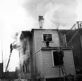
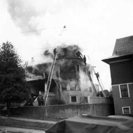
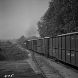
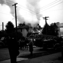
Photograph depicts a house fire in West End of Vancouver.
Photograph depicts a house fire possibly on 1000 Beach Block and Thurlow St. , caused by a wrecking gang.
Photograph depicts a house fire on 1000 Beach Block and Thurlow St. on December 18, 1964. A wrecking gang accidently set fire to the house and it took one hour to get the fire under control.
Photograph depicts an Independent Order of Foresters 1895 house.
Photograph depicts a house on Ladner Trunk Rd. in Delta, B.C. It is in the northeast corner of an intersection with the road leading to the Canadian Army Signal Station.
Photograph depicts the Moha "ghost" vilage, 20 miles west of Lillooet, at the fork of Bridge and Yalako Rivers. It used to be a gold mining village. About 8 houses/cabins were left standing, but none were occupied. Displayed is one that had 2 ft. thick walss to waist height, as shown.
Photograph depicts the house opposite an 1876 church in Nicola village, 7 miles northeast of Merritt. It may be the manse.
Photograph depicts a house on 10th Ave., Vancouver.
Photograph depicts a house that had been pushed on its side by a bulldozer.
Photograph depicts a house that at the moment was being pushed up on its side by a bulldozer.
Photograph depicts one of the four houses on the corner of Barclay and Nicola. It was being demolished to make way for high rise apartments.
Photograph depicts a house being gutted, prior to demolition.
Photograph depicts one of four houses that were being gutted and demolished to make way for a concrete high rise apartment block. Built circa 1905.
Photograph depicts a house that had a "sold" notice on it and was partly demolished. Up to the date the photograph was captured, this block on Beach Ave. was the sole remaining one to have only houses on it, as opposed to a mixture of houses and apartment blocks, or blocks only.
Photograph depicts a house on the southern edge of Chinatown.
Photograph depicts a house that was probably built in 1890-1900. It had just been demolished.
Photograph depicts one of the few remaining inhabioted and well kept houses that still survived in the very heart of downtown Vancouver.
Photograph depicts a house on Nicola St. at the southwest corner of the intersection of Nicola and Robson St., in Vancouver, B.C.
Photograph depicts a well cared for house that was empty and being stripped along with 3 other house on Barclay to make way for a high rise apartment block. Built circa 1905.
Photograph depicts a house on the east side of Ontario Street, Vancouver.
Photograph depicts a house that had just been repainted on the north side of Pender Street.
Photograph depicts a house that provided an example of the few surviving homes left on Beach Ave.
Photograph taken looking northwest at a corner house and another home to its left. They were 2 of 9 houses in this Beach Block, the last block of houses on Beach Ave.
Photograph depicts a few houses on Beach Ave., Vancouve. They were examples of about a dozen surviving homes on Beach Ave.
Photograph depicts "H.R. Macmillan," a private yacht.
Photograph depicts Hudswell Clarke 0-6-0 diesel shunter locomotive #21, owned and on the premises of Vancouver Wharves Ltd. in North Vancouver. It is having a new transmission installed and receives an annual paint job in sky blue. It has a Gardiner (Manchester) engine. Comes the plate "Samuel Williams & Sons Ltd." (of Dagenham, Essex, U.K.), which is the parent company of the V.W. Ltd.
Photograph depicts an embankment across the inlet of Hydraulic Lake on the CPR line. This a the south end of the McCulloch depot and you can see the buildings in the distance. It is located at mile 76.5 on the Carmi Subdivision, about 27 miles northeast of Penticton.
Photograph depicts a hydraulic sluicing monitor that was not a piece on display in the exhibit, but was a piece of abandoned equipment found below Barkerville town. It was made by Empire Foundry, Marysville, California.
Photograph depicts the end part of an idle car nearest to a crane boom.
Postcard depicts Illecillewaet Valley. Taken adjacent to snowsheds and the second crossing of the Illecillewaet River. It had the appearance of being the location for a safety switch and spur to divert a runaway train that had come down the "Loop" from Glacier Station.
Postcard depicts Illecillewaet Valley. Circa 1914-16. New grade being built for use with Connaught Tunnel grade reductions at Rogers Pass. Original right-of-way still in use.
Postcard depicts Illecillewaet Valley and Loop from Observation Point, Glacier B.C., on the CPR line.
Postcard depicts Illecillewaet Valley and Loop near Glacier, BC
Postcard depicts Illecillewaet Valley from Lookout Point on Mt. Abbott, near Glacier B.C.
Postcard depicts Imperial Limited on the Great Loop in the Selkirks, near Glacier, BC
Photograph depicts an implement shed at Cloverdale in the Fraser Valley on the Pacific Highway.
Postcard depicts Kicking Horse Canyon.
Photograph depicts a view of Indian Arm, looking south from Granite Falls.
Photograph depicts an Indian Roman Catholic church at the mouth of Anderson Lake. No services were held anymore. It was externally restored in 1968 by the white people of the village, while the Natives did the interior. Unfortunatley, there was no work done on the interior as of the date the photograph was captured.
Photograph depicts an industrial item atop logs and tracks.
Photograph depicts the inner harbour at Victoria and the C.P. ship the "Princess Patricia."
Photograph depicts the inner harbour at Victoria and the C.P. ship the "Princess Patricia" putting to sea.
Photograph depicts an inscription cut into a rock face found in Bedwell Harbour. The HMS Segeria, dated 1873-1911, was the only warship in Esquimalt at Queen Victoria's death responsible for firing the death salute of 81 guns, the Queen's age. The ship also served in the Pacific as a survey vessel rom 1897-1910. After, it was sold as a Boys Naval Brigade ship in Vancouver.
Photograph depicts an interchange freight train making for the Pacific Great Eastern yards. It is just off the Second Narrows Bridge in Vancouver, B.C.
Photograph depicts the intersection at Cordero and Barclay St. in the west end of Vancouver. The view is looking north along Cordero St.
Photograph taken at the intersection of Cardero and Barclay Streets, looking northeast. Captured at 925 Cardero, the Buckingham Apartments.
Photograph depicts the intersection at Cordero and Nelson St. in the west end of Vancouver. The view is looking north along Cordero St.
Photograph taken at the intersection of Nelson and Denman Streets. Three quarters of the blook had just been cleared for a new high rise and shopping complex.